
The epzik8 Webpage
Interstate 95 south - Springfield to Fredericksburg

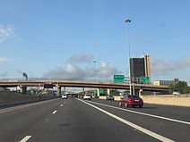
At the Springfield Interchange (exit 170) in Springfield, Virginia, Interstate 95 leaves the Capital Beltway (Interstate 495) onto its own southbound alignment toward Richmond, the state capital. Photo taken 07-14-2025.

The long flyover ramp carrying southbound I-95 traffic from the Beltway onto the Henry G. Shirley Highway (a name inherited from Interstate 395 to the north), ends up ahead. Photo taken 07-14-2025.

Another feature taken from I-395 is the express HOV lanes in the median at left, which will continue for some time beyond this point. Photo taken 07-14-2025.
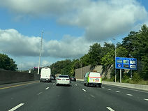
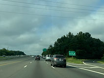
At right, along a separate southbound carriageway, an overhead sign mentions a "Mall" (Springfield Town Center) being off exit 169A. Photo taken 07-14-2025.

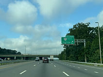
Ahead, a flyover ramp runs from westbound Franconia Road (secondary route 644) to I-95 south. Photo taken 07-14-2025.

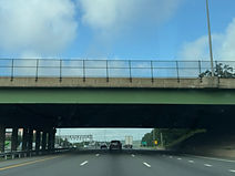
Franconia Road passes overhead with a rather low vertical clearance as I-95 works its way through exit 169. This exit was involved in the massive Springfield Interchange reconstruction project that lasted nearly a decade, commencing in 1999 and not concluding until 2008. Photo taken 07-14-2025.

Prior to the express offramp to Franconia-Springfield Parkway (Virginia State Route 289), there is one-mile advance signage along the mainline carriageway for exit 167 with Backlick Road (southbound SR 617) and Fullerton Road. Photo taken 07-14-2025.

A flyover ramp from the southbound express lanes to the mainline lanes is ahead. Photo taken 07-14-2025.

VA 289 subsequently passes overhead. Photo taken 07-14-2025.

Gas and food services are available at exit 167. Photo taken 07-14-2025.

Exit 167 is ahead on the right. Photo taken 07-14-2025.

The exit 167 gore sign is unnumbered. Photo taken 07-14-2025.

Exit 166 intersects the Fairfax County Parkway (Virginia State Route 286) with control cities of Newington and Fort Belvoir. Exit 166A leads to the National Museum of the U.S. Army. Photo taken 07-14-2025.

Trucks bound for the north side of Fort Belvoir can use VA 286 north. Photo taken 07-14-2025.

Exit 166A can be used to access the historic Mount Vernon estate, while exit 166B leads to Heller Road. Photo taken 07-14-2025.

A connector between Heller and a ramp to I-95 north passes overhead here. Photo taken 07-14-2025.

Exit 166B is reached ¼ mile before exit 166A. Photo taken 07-14-2025.

Exit 166B is seen on the right. Photo taken 07-14-2025.

Exit 166A then appears. Photo taken 07-14-2025.

Then, a northbound-only ramp from the express lanes leads to Alban Road and Boudinot Drive. Photo taken 07-14-2025.

A sign to the right then touts Virginia as being a Purple Heart state, acknowledging U.S. military personnel lost in action over the years. Photo taken 07-14-2025.

Lorton, where the next exit is located, is 3 miles ahead, and Richmond is 91 miles away. Photo taken 07-14-2025.

Between exits, I-95 crosses the Potomac River tributary Accotink Creek. Photo taken 07-14-2025.

Exit 163 is the first of a string of several with Virginia Railway Express (VRE) commuter rail service. This exit leads to the Lorton station. Photo taken 07-14-2025.

Exit 163 also leads to the northern terminal of the Amtrak Auto Train (just south of the VRE platform), whose southern end is in Sanford, Florida. Photo taken 07-14-2025.

I-95 goes on to cross Pohick Creek. Photo taken 07-14-2025.

Exit 163 can be used to reach George Mason's 18th-century Gunston Hall mansion, as well as Pohick Bay Park on the Potomac. Photo taken 07-14-2025.

The intersecting road at exit 163 is Lorton Road (SR 642). Photo taken 07-14-2025.

I-95 then goes over Lorton Road. Photo taken 07-14-2025.

The cities of Fredericksburg and Richmond are a respective 36 and 88 miles from this sign. Photo taken 07-14-2025.

Between exits, there is I-95 reassurance. Photo taken 07-14-2025.

Exit 161, one mile away, is a left exit leading to southbound U.S. Route 1 (Richmond Highway) and the area of Woodbridge. Photo taken 07-14-2025.

An express lane entrance, opened only when the lanes are pointed for southbound traffic, is just past exit 161. Photo taken 07-14-2025.

The Occoquan Bay National Wildlife Refuge can be reached from this exit. Photo taken 07-14-2025.

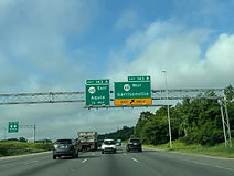
As the distances to the next three southbound exits are posted overhead, the travel time to the Aquia area of Stafford County is displayed by a variable message sign. Photo taken 07-14-2025.

Exit 161 also leads toward Mason Neck on the Potomac. Photo taken 07-14-2025.

The Interstate curves widely to the right before reaching exit 161. Photo taken 07-14-2025.

One mile away, exit 160 leads to northbound Virginia State Route 123 (Gordon Boulevard) which goes toward Occoquan and Lake Ridge. Photo taken 07-14-2025.

Exit 160 can be taken to the Historic Occoquan area. Photo taken 07-14-2025.

The Prince William County Stadium Complex can also be reached from this exit. Photo taken 07-14-2025.

The highway then crosses Furnace Road (SR 611). Photo taken 07-14-2025.

The highway's right lane is now set aside for exit 160, while the lane to the left of that ends in 1,500 feet. Photo taken 07-14-2025.

As it nears exit 160, I-95 uses the Purple Heart Bridge to cross the Occoquan River from Fairfax into Prince William County. This bridge is one of the most commonly congested areas along this portion of I-95. Photo taken 07-14-2025.

It is along this bridge that the Shirley Highway moniker ends. Photo taken 07-14-2025.

The express and mainline offramps for exit 160 both lie ahead. Photo taken 07-14-2025.

The exit 160 gore sign. Photo taken 07-14-2025.

VA 123 subsequently passes over the Interstate. Photo taken 07-14-2025.

I-95's next exit will be at the Prince William Parkway (VA 294). Photo taken 07-14-2025.

In the meantime, the highway crosses Occoquan Road. Photo taken 07-14-2025.

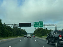
I-95 meets VA 294 at exit 158; the route goes west to Manassas and east to Woodbridge. Photo taken 07-14-2025.
Lodging available at exit 158B is posted at right. Photo taken 07-14-2025.

Approaching exit 158, the express lanes have advance signage for their Dale City/Rippon Landing offramp. Photo taken 07-14-2025.

Potomac Mills can be reached from exit 158B or 156B, and the Potomac Town Center from exit 156A. Photo taken 07-14-2025.

Exit 158B is ¼ mile prior to exit 158A. Photo taken 07-14-2025.

The entrance to exit 158B is seen ahead. Photo taken 07-14-2025.

Exit 158A is on the other side of VA 294's crossing of the Interstate. Photo taken 07-14-2025.

Exit 156A up ahead can be used to reach the Rippon VRE station. Photo taken 07-14-2025.

Exit 156, which intersects Dale Boulevard (SR 784) and has control cities of Dale City and Rippon Landing, is a mile away. Photo taken 07-14-2025.

Another express-to-mainline ramp passes above here. Photo taken 07-14-2025.

A car rest area can be reached from this exit, while a truck rest area is another 3½ miles away. Photo taken 07-14-2025.

The next rest area after this one is 26 miles away. Photo taken 07-14-2025.

Some of the services available at exit 156B are posted to the right. Photo taken 07-14-2025.

The Hylton Memorial Chapel Events Center can be reached from this exit. Photo taken 07-14-2025.

This exit can also be taken to the Woodbridge campus of the Northern Virginia Community College, as well as Leesylvania State Park. Photo taken 07-14-2025.

Exit 156 lies straight ahead; the rest area entrance is to the left along the exit roadway. Photo taken 07-14-2025.

Each offramp of exit 156 is half a mile apart, while the rest area is a mile away. Photo taken 07-14-2025.

Exit 156A is right on the other side of the Dale Boulevard overpass. Photo taken 07-14-2025.

The exit 156A gore sign is at far right. Photo taken 07-14-2025.

At left, the express lanes have advance notice for their access point to the approaching Dumfries/Manassas exit. Meanwhile, mainline I-95 has narrowed to three lanes in each direction. Photo taken 07-14-2025.

The car rest area entrance is to the right. Photo taken 07-14-2025.

There is I-95 reassurance as traffic coming from Dale City and the rest area enters the highway, which then crosses Cardinal Drive. Photo taken 07-14-2025.

A weigh station is included at a truck rest area a mile away. Photo taken 07-14-2025.

Fredericksburg and Richmond now lie 27 and 79 miles away. Photo taken 07-14-2025.

The highway goes on to cross Powells Creek. Photo taken 07-14-2025.

The weigh station and truck rest area entrance is at right. Photo taken 07-14-2025.

In one mile, I-95 will meet Virginia State Route 234 (Dumfries Road) toward Manassas and Dumfries at exit 152. Photo taken 07-14-2025.

Some of the food options at exit 152 are listed at right. Photo taken 07-14-2025.

The Manassas Regional Airport and the community of Montclair can both be reached from exit 152B. Photo taken 07-14-2025.

Exit 152B precedes exit 152A by half a mile. Photo taken 07-14-2025.

The Weems-Botts Museum in historic Dumfries can be reached from exit 152A. Photo taken 07-14-2025.

This overhead sign points the way to exit 152B. Photo taken 07-14-2025.

The exit 152B gore sign. Photo taken 07-14-2025.
Exit 152A goes to VA 234 south, which goes about half a mile to its southern terminus at US 1. Photo taken 07-14-2025.
VA 234 then passes overhead. Photo taken 07-14-2025.

The southbound carriageway subsequently receives traffic from VA 234. Photo taken 07-14-2025.

The express lanes will have a southbound Triangle/Quantico ramp shortly. From this point, the next 9 miles of the express lanes were completed and opened to traffic in 2014. Photo taken 07-14-2025.

The Interstate crosses Batestown Road (SR 629), formerly Mine Road, between exits. Photo taken 07-14-2025.

The Quantico VRE station is off exit 150A up ahead. Photo taken 07-14-2025.

The Quantico express ramp lies ahead. Photo taken 07-14-2025.

Exit 150A can also be taken to the National Museum of the Marine Corps. Photo taken 07-14-2025.

Exit 150B leads to westbound SR 619 (Joplin Road) and the Prince William Forest Park up ahead. Photo taken 07-14-2025.

Meanwhile, exit 150A, which comes afterward, has control cities of Triangle and Quantico. Photo taken 07-14-2025.
The exit 150B gore sign. Photo taken 07-14-2025.

This sign then points toward exit 150A. Photo taken 07-14-2025.

I-95 goes on to cross Joplin Road. Photo taken 07-14-2025.

The Interstate pulls away from exit 150, and commercial vehicles are directed to use the right two lanes of the highway. Photo taken 07-14-2025.

A blank service sign for exit 148 is then seen at right. Photo taken 07-14-2025.

Exit 148, one mile away, intersects Russell Road which leads to the Marine Corps Base Quantico. Photo taken 07-14-2025.

Commercial vehicles bound for Quantico are to use this exit. Photo taken 07-14-2025.

Exit 148 also leads toward Widewater State Park. Photo taken 07-14-2025.

Exit 148 lies straight ahead, about half a mile west of the Marine Corps Exchange. Photo taken 07-14-2025.

The southbound offramp of this interchange begins at the top of a somewhat steep hill. Photo taken 07-14-2025.

The highway glides downward to its crossing of Russell Road. Photo taken 07-14-2025.

Just after the exit, at a bridge over Chopawamsic Creek, I-95 departs Prince William for Stafford County, one of many Virginia jurisdictions that boasts of being a "Certified Business Location". Photo taken 07-14-2025.

Climbing back uphill, there is an I-95 shield to the right and a northbound express ramp to mainline I-95 to the right. Photo taken 07-14-2025.

An express lane message display sits in front of the Telegraph Road (SR 637) overpass. Since the lanes were pointed north at the time, the gates at the southbound entrance ahead were closed. Photo taken 07-14-2025.

The express lane entrance flies overhead, as is the case with other express lane entrances. Photo taken 07-14-2025.

Lodging options at the forthcoming exit 143 are displayed on the blue sign at right. Photo taken 07-14-2025.

The Interstate crosses Aquia Creek between exits. Photo taken 07-14-2025.

Exit 143, intersecting Garrisonville Road (SR 610) toward Garrisonville and Aquia, is a mile away. Photo taken 07-14-2025.

Exit 143A can be used to get to US 1, and the northbound iteration of this exit does lead directly to US 1. Photo taken 07-14-2025.

At right, a southbound express ramp merges onto mainline I-95 south which will connect exiting express traffic with exit 143 proper. Photo taken 07-14-2025.

One whole lane of the highway is marked for exit 143B. Photo taken 07-14-2025.
Exits 143B and A are spaced half a mile apart. Photo taken 07-14-2025.

The exit 143B gore sign. Photo taken 07-14-2025.

I-95 passes under SR 610 prior to exit 143A. Photo taken 07-14-2025.

The Interstate subsequently receives traffic from eastbound SR 610 on the right. Photo taken 07-14-2025.

A construction project between 2019 and 2023 extended the express lanes from this point about another 10 miles further south to Falmouth, just north of Fredericksburg. Photo taken 07-14-2025.

Fredericksburg and Richmond now sit 15 and 67 miles away. Photo taken 07-14-2025.

The food options available at exit 140 are posted at right; this includes mentions of Publix and Sheetz on the same sign. Photo taken 07-14-2025.

Exit 140 intersects Courthouse Road (SR 630) toward Stafford, the eponymous seat of Stafford County, in one mile. Photo taken 07-14-2025.

The Stafford County Sheriff's Office can be reached from exit 140. Photo taken 07-14-2025.

This exit can also be used to reach the Stafford Civil War Park. Photo taken 07-14-2025.

This exit additionally leads toward the Brooke VRE station. Photo taken 07-14-2025.

Exit 140 is just ahead on the right. Photo taken 07-14-2025.

In its current configuration, exit 140 is a diverging diamond interchange (DDI) where each direction of Courthouse Road crosses over one another so that traffic briefly drives on the left through the interchange. Photo taken 07-14-2025.

Courthouse Road passes over I-95 using this pair of overpasses. Photo taken 07-14-2025.

Beyond exit 140, Fredericksburg and Richmond are 12 and 64 miles away. Photo taken 07-14-2025.

The highway soon passes under American Legion Road (SR 628). Photo taken 07-14-2025.

A blank lodging sign for exit 136 sits at right, perhaps as a provision. Photo taken 07-14-2025.
Exit 136 intersects Centreport Parkway (SR 8900) and leads to US 1, and the Stafford Airport. Photo taken 07-14-2025.

In the meantime, the highway goes downhill and crosses the Potomac Creek. Photo taken 07-14-2025.

Exit 136, a fairly new addition to this part of I-95 opening in 2005, is straight ahead. Photo taken 07-14-2025.

The Interstate proceeds under Centreport Parkway. Photo taken 07-14-2025.

It then passes under Enon Road (SR 627). Photo taken 07-14-2025.

Lodging options at exit 133 are soon posted to the right. Photo taken 07-14-2025.

The area of Thornburg, in Spotsylvania County, is 16 miles and minutes away from this variable message sign. Photo taken 07-14-2025.

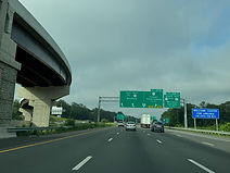
At left, an express ramp will soon provide access to the two northern Fredericksburg exits (133 and 130). Photo taken 07-14-2025.

Exit 133 and 130, which variously intersect mainline and Business U.S. Route 17 and Virginia State Route 3, have their own southbound exit roadway. Photo taken 07-14-2025.

Exit 130B (VA 3 west) can be used to reach Culpeper, in the county of the same name. Photo taken 07-14-2025.

Gas options at exit 133 are posted at the right. Photo taken 07-14-2025.
A Virginia welcome center is located in the vicinity of exit 130. Meanwhile, on this overhead gantry, southbound US 17 Bus. (exit 133A) is revealed to have a control city of Falmouth. Photo taken 07-14-2025.

Exit 133A can be used by interests to VRE's Leeland Road station. Photo taken 07-14-2025.

The exit 130 access road begins half a mile after exit 133. Photo taken 07-14-2025.

Exit 133A also leads toward George Washington's Ferry Farm and Chatham Manor on the Rappahannock River. Photo taken 07-14-2025.

Truslow Road (SR 652) crosses the Interstate right before exit 133. Photo taken 07-14-2025.

The entrance to the exit 133/130/rest area access lanes is to the right, just ahead of the express flyover ramp toward those exits. Photo taken 07-14-2025.

This more or less marks the end of I-95's Virginia express lanes. The Interstate will spend the next 7 miles concurrent with US 17 as it passes just west of Fredericksburg. Photo taken 07-14-2025.
