
The epzik8 Webpage
Interstate 95 north - Wilson to Virginia line

Pulling away from exit 121 just west of Wilson, North Carolina, northbound Interstate 95 receives traffic at right from U.S. Route 264 Alternate, which runs through downtown Wilson while paralleling mainline U.S. Route 264 (accessible from nearby exit 119) between Zebulon in Wake County and Greenville in Pitt County. Photo taken 10-06-2023.

I-95 proceeds to cross over a tributary of the Bloomery Swamp, part of the Neuse River Basin. Photo taken 10-06-2023.

The highway passes through heavy forest, complete with tree-lined median. Photo taken 10-06-2023.

Around mile marker 124.5, I-95 enters Nash County. Photo taken 10-06-2023.

Exit 127, North Carolina Highway 97 toward the Rocky Mount-Wilson Regional Airport, is a mile away. Photo taken 10-06-2023.

Before the exit, I-95 enters the Tar-Pamlico River Basin. Photo taken 10-06-2023.

Exit 127 lies just ahead. NC 97 runs 64 miles east-west between U.S. Route 64 Business in Zebulon and North Carolina Highway 122 in Hobgood, Halifax County. Photo taken 10-06-2023.

The onramp from NC 97 comes in to the right. Photo taken 10-06-2023.

Exit 97 is followed by I-95 reassurance. Photo taken 10-06-2023.

A crossing of the Tar River follows. Photo taken 10-06-2023.

Slightly further along, North Carolina Highway 58 crosses over the freeway. Photo taken 10-06-2023.

The next exit, 132, leads to NC 58 via Sandy Cross Road (SR 1575). Photo taken 10-06-2023.

Exit 132 represents one northbound access point to Rocky Mount. Photo taken 10-06-2023.

As exit 132 nears, I-95 crosses over Sapony Creek. Photo taken 10-06-2023.

Exit 132 veers off to the right ahead. It appears as though NCDOT mixed up the "TO" and "NC" on the advance signs for the exit. Photo taken 10-06-2023.

With the trees backing off somewhat, I-95 continues its northward push. Photo taken 10-06-2023.

In two miles, the Interstate reaches exit 138, intersecting U.S. Route 64 and serving Rocky Mount, Nashville (North Carolina), and Tarboro. Photo taken 10-06-2023.

The North Carolina Aquarium on Roanoke Island and the Cape Hatteras National Seashore, both on the Outer Banks, can be accessed from exit 138 eastbound. Photo taken 10-06-2023.

Exit 138 is down to one mile away. Photo taken 10-06-2023.

The Interstate crosses over a railroad line here, then approaches Sunset Avenue, where a new exit (137) is under construction as of 2023. Photo taken 10-06-2023.

Exit 138 leaves I-95 in the form of a collector-distributor roadway, from which the ramps to each direction of US 64 are then accessed. Exit 138A (US 64 east) is ahead at right. Exit 138B (US 64 west) has an additional control city of Raleigh here. Photo taken 10-06-2023.

Exit 138B is at right. Photo taken 10-06-2023.

Traffic from each direction of US 64 then prepares to merge onto I-95 north, at right. Photo taken 10-06-2023.

I-95 crosses Stony Creek as US 64 traffic comes in. Photo taken 10-06-2023.

Hunter Hill Road (SR 1604) crosses over the Interstate following the exit. Photo taken 10-06-2023.

At mile marker 139.5, Roanoke Rapids and Richmond are 37 and 116 miles away. Photo taken 10-06-2023.

Exit 141, North Carolina Highway 43 leading to Red Oak, is in three-quarters of a mile. Photo taken 10-06-2023.

Nearing exit 141, damage from a tornado that hit the Rocky Mount area in July 2023, two and a half months earlier, is still clearly evident. Photo taken 10-06-2023.

Gas stations at exit 141 are Shell, Circle K and 76. Photo taken 10-06-2023.

Exit 141 is impending. NC 43 runs nearly 120 miles from the New Bern area northwest to NC 58 in Warren County, passing through Greenville along the way. Photo taken 10-06-2023.

One mile north of exit 141 sits a rest area, the final one on I-95 north in North Carolina. Photo taken 10-06-2023.

The onramp from NC 43 comes in at the corresponding mile marker 141. Photo taken 10-06-2023.

North Halifax Road (SR 1544) crosses I-95 after exit 141. Photo taken 10-06-2023.

The rest area is ahead, stated as "next exit". Photo taken 10-06-2023.

The rest area entrance, at right, alongside a heavy swath of trees. The next rest area is the Virginia welcome center, about 39 miles to the north. Photo taken 10-06-2023.

Traffic leaving the rest area proceeds back onto northbound I-95 ahead at right. Photo taken 10-06-2023.

This is followed by a wide curve to the left as the Interstate leaves the city limits of Dortches. Photo taken 10-06-2023.

The next exit, 145, indirectly intersects North Carolina highways 4 and 48, the former of which leads east to U.S. Route 301, and the latter southeast to Gold Rock and Rocky Mount. It is two miles from this BGS. Photo taken 10-06-2023.

The highway manages to straighten out for a considerable period in between exits. Photo taken 10-06-2023.

Exit 145 accesses the North Carolina Wesleyan University. Photo taken 10-06-2023.

Lodging and attractions at exit 145 are displayed by this blue sign. Photo taken 10-06-2023.

Gas options at the exit are an Exxon, Shell and BP. There also appear to have been two others in the past that have been removed from this sign. Photo taken 10-06-2023.

Exit 145 is just behind another Halifax Road crossing. Photo taken 10-06-2023.

Reconstruction of exit 145 during 2022-23 added additional ramps, roundabouts and a connection between Halifax Road and the interchange, with a new overpass being built over the Interstate. Photo taken 10-06-2023.

After exit 145, I-95 crosses over Swift Creek. Photo taken 10-06-2023.

The Swift Creek bridge is followed by I-95 reassurance. Photo taken 10-06-2023.

As the Interstate encounters an overpass (Watson Seed Farm Road, SR 1510) under reconstruction, Roanoke Rapids and Richmond are a respective 31 and 110 miles away. Photo taken 10-06-2023.

A patch of open land to the right provides a short break from the constant mobs of trees. Photo taken 10-06-2023.

Just further ahead, drivers are warned of litter pickup that was ongoing along this segment of I-95 at the time of these photos. Photo taken 10-06-2023.

Exit 150, North Carolina Highway 33 toward Whitakers, is two miles away. This is I-95's final northbound exit in Nash County. Photo taken 10-06-2023.

The highway proceeds to cross the Beaverdam Swamp Creek. Photo taken 10-06-2023.

A previously-advertised BP and Subway are located together at exit 150. Photo taken 10-06-2023.

Exit 150 has arrived. With its western terminus feet away from the interchange at NC 4/48, NC 33 goes nearly 110 miles eastward to Hobucken in coastal Pamlico County, via the north side of Greenville. Photo taken 10-06-2023.

This recently-reconstructed bridge carries NC 33 over I-95. Photo taken 10-06-2023.

A weigh station sits one mile past the exit. Photo taken 10-06-2023.

Meanwhile, much sooner after the exit there is I-95 reassurance. Photo taken 10-06-2023.

All traffic deemed a "truck" must stop at the weigh station for an inspection. Photo taken 10-06-2023.

In the meantime, I-95 prepares to cross over the Tar River tributary Fishing Creek. Photo taken 10-06-2023.

The Fishing Creek crossing takes I-95 into Halifax County, where it will spend about 23 miles and have five exits. Photo taken 10-06-2023.

The weigh station is curiously located just after the bridge rather than before it. Photo taken 10-06-2023.

Exiting weigh station traffic rejoins the Interstate at right. Photo taken 10-06-2023.

I-95 is now entering the Northeast North Carolina Economic Development Region. Photo taken 10-06-2023.

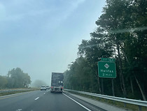
A formal welcome from Halifax County is finally seen here, at the Bellamy Lake Road overpass. Photo taken 10-06-2023.

Approaching the next exit, the city of Roanoke Rapids uses the open field to the right to advertise some of the hotels they have to offer at exits 171 and 173. Photo taken 10-06-2023.

Intersecting North Carolina Highway 481 and serving the town of Enfield, exit 154 sits one mile from this sign. Photo taken 10-06-2023.

Before the exit comes a crossing of the Rocky Swamp. Photo taken 10-06-2023.

Exit 154 sits just ahead. Much shorter than other state highways intersected by this segment of I-95, NC 481 runs 21 miles between the Halifax County communities of Glenview and Tillery. Photo taken 10-06-2023.

A close-up of the exit 154 gore. Photo taken 10-06-2023.

Past exit 154, with fresh pavement, I-95 is greeted by a billboard for the Roanoke Rapids Sheetz. Photo taken 10-06-2023.

Roanoke Rapids and Richmond are now a respective 22 and 101 miles away. Photo taken 10-06-2023.

A short time later, Ringwood Road (SR 1002) passes over the Interstate. Photo taken 10-06-2023.

Some DOT landscaping work then pops up in the median, at left. Photo taken 10-06-2023.

Exit 160, intersecting North Carolina Highway 561, is eventually announced as just over a mile away. Photo taken 10-06-2023.

Louisburg, the seat of Franklin County to the west, is off exit 160. Photo taken 10-06-2023.

Exit 160 is here as evidenced by the gore sign. Photo taken 10-06-2023.

A distance beyond the exit, Hedgepeth Road passes over the Interstate. Photo taken 10-06-2023.

During the nearly eight miles between exits - the second-longest such gap on I-95 in North Carolina - the highway has to deal with more trees. Here, there are deciduous trees in the median and pines to the right. Photo taken 10-06-2023.
Eventually, there comes a two-mile advance sign for exit 168, intersecting North Carolina Highway 903 and serving county seat Halifax. Photo taken 10-06-2023.

Exit 168 is the site of the Halifax Industrial Park. Photo taken 10-06-2023.

Also accessible from this exit is the Halifax State Historic Site. Photo taken 10-06-2023.

Food options at the exit are Burger King, Subway and Dunkin', although these are all inside of gas stations. Photo taken 10-06-2023.

Exit 168 now arrives. NC 903 is one of North Carolina's longest state highways in spite of its high number, winding its way 200 miles through the state's east from Garland in Sampson County to the Virginia line in Warren County, and is another thoroughfare running through Greenville. Photo taken 10-06-2023.

NC 903 itself crosses over I-95 here. Photo taken 10-06-2023.

After exit 168 comes another I-95 marker. Photo taken 10-06-2023.

At mile marker 168.5, Weldon (a twin town of sorts to Roanoke Rapids) and Richmond are 7 and 87 miles away. Photo taken 10-06-2023.

The next two exits each serve Roanoke Rapids. Photo taken 10-06-2023.

There is plenty of food to be had at the forthcoming exit 171. Photo taken 10-06-2023.

Exit 171 is also another exit for Historic Halifax. Photo taken 10-06-2023.

Exit 171 intersects North Carolina Highway 125 and is half a mile ahead. NC 125 can be used as a shortcut northbound into downtown Roanoke Rapids. Photo taken 10-06-2023.

A hospital (ECU North) and highway patrol station can also be reached from this exit. Photo taken 10-06-2023.

Exit 171 is now imminent. Photo taken 10-06-2023.

Within exit 171 sits a two-mile advance sign for exit 173, intersecting U.S. Route 158 and marked toward Roanoke Rapids (west) and Weldon (east). Photo taken 10-06-2023.

On the right at the north end of exit 171 sits the still-in-progress Carolina Crossroads complex. Photo taken 10-06-2023.

Some of the many hotels available at exit 173 are billed by this blue sign. Photo taken 10-06-2023.

The Interstate proceeds slightly uphill to exit 173. Photo taken 10-06-2023.

Both exit 173 gores (north and south) are asphalt rather than grass. The exit is also a sort of "Breezewood of the South" for its array of highway amenities in the style of Breezewood, Pennsylvania, where Interstate 70 has its eastern junction with the Pennsylvania Turnpike. Photo taken 10-06-2023.

I-95 crosses over US 158, then a freight railroad track immediately afterward. Photo taken 10-06-2023.

There is I-95 reassurance as the northbound carriageway receives traffic from US 158. Photo taken 10-06-2023.

The speed limit has remained 70 miles per hour all this time. Photo taken 10-06-2023.

The Interstate now crosses the historic Roanoke River into Northampton County, the last of the eight North Carolina counties it traverses. Photo taken 10-06-2023.

The Virginia line and Emporia are 8 and 18 miles from this sign. Photo taken 10-06-2023.

The highway continues over a swamp running north of the Roanoke proper. Photo taken 10-06-2023.

The Interstate now reaches exit 176 (the first of two in Northampton County), North Carolina Highway 46 toward Gaston and Garysburg. Photo taken 10-06-2023.

NC 46 runs 17 miles east-west entirely within Northampton County, and crosses over I-95 here. Photo taken 10-06-2023.

Another I-95 reassurance marker follows the exit. Photo taken 10-06-2023.

I-95 spends its final few miles in North Carolina within the Chowan River Basin. Photo taken 10-06-2023.

Exit 180, the final northbound exit in the state, is where NC 48 once again crosses paths with I-95, having run a few miles to the Interstate's west from the Rocky Mount area. Photo taken 10-06-2023.

Off exit 180 is the Northampton County Commerce Park. Photo taken 10-06-2023.

Meanwhile, the Commonwealth of Virginia is gracious enough to advertise their northbound welcome center two miles ahead. Photo taken 10-06-2023.

Exit 180 sits just beyond a curve to the left. Photo taken 10-06-2023.

The exit 180 gore sign and offramp. NC 48 ends just to the east of here, at US 301 in Pleasant Hill. Photo taken 10-06-2023.

About a mile further along, the state line is approaching, and a blue sign notes that after the Virginia welcome center, the next rest area is in 36 miles - namely, in the Carson area of Sussex County. Photo taken 10-06-2023.

The welcome center entrance is to the right. Photo taken 10-06-2023.

On this note, I-95 parts from North Carolina and enters Greensville County, Virginia. It will spend the next 178 miles in the Old Dominion, passing through Petersburg, Richmond and the southern suburbs of Washington, DC, i.e. Northern Virginia. Photo taken 10-06-2023.
