
The epzik8 Webpage
Interstate 95 north - Richmond to Fredericksburg

In Glen Allen, Virginia, in Henrico County north of Richmond, Interstate 95 north reaches exit 84B, a cloverleaf ramp leading to northbound Interstate 295. I-95 now exits the immediate Richmond area. (7-19-2025)

Hotels located at exit 86B up ahead are displayed by this blue sign. (7-19-2025)

Competitors Sheetz and Wawa have gas stations on each side of I-95 at exit 86. (7-19-2025)

Northbound I-95 curves right, momentarily diverging from the southbound carriageway, and passes over the long ramps from I-95 south to I-295 south and from I-295 north to I-95 north, followed quickly by Virginia Center Parkway. (7-19-2025)
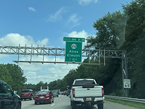
Exit 86 intersects Sliding Hill Road (SR 656) toward Atlee and Elmont. (7-19-2025)

A fourth lane briefly appears to the right for traffic exiting at 86A. (7-19-2025)

Exit 86A leads to the Hanover Municipal Airport. (7-19-2025)

At the beginning of exit 86, I-95 leaves Henrico County for Hanover County. (7-19-2025)

The exit gore for exit 86. (7-19-2025)

Exit 86A to SR 656 east is on the other side of the Kings Acres Road overpass. (7-19-2025)

SR 656 itself passes overhead soon afterward. (7-19-2025)

The sign at right points toward exit 86B. (7-19-2025)

I-95 then receives traffic from each leg of exit 86. (7-19-2025)

Two lanes of traffic enter at right from the exit. (7-19-2025)

I-95 soon passes mile marker 88. (7-19-2025)

This is followed by I-95 reassurance. (7-19-2025)

Exit 89 with Lewistown Road (SR 802) is a mile away, and has its own exit lane. (7-19-2025)

Services available at exit 89 are listed at right. (7-19-2025)

Exit 89 is now reached. This interchange underwent substantial reconstruction during the mid-2010s. (7-19-2025)

The Lewistown overpass is located here. (7-19-2025)

More I-95 reassurance follows exit 89. (7-19-2025)

Hotels located at exit 92B are soon displayed on the right. (7-19-2025)

Exit 92, 1½ miles away, intersects Virginia State Route 54, toward Hanover and Ashland. (7-19-2025)

Before the exit, I-95 passes under Ashcake Road (SR 657). (7-19-2025)

Exit 92B leads to a Hanover/Ashland tourist info center as well as the Scotchtown historic site. (7-19-2025)

Exit 92A meanwhile leads to the historic Hanover Tavern. (7-19-2025)

Randolph-Macon College is also off exit 92B. (7-19-2025)

Exit 92A to VA 54 east is half a mile away. (7-19-2025)

I-95 proceeds into Ashland city limits at this point. (7-19-2025)

Exit 92B follows 92A by ¼ mile. Photo taken 07-19-2025.

Exit 92B to VA 54 west is ahead on the right. Photo taken 07-19-2025.

After exit 92, Fredericksburg is 40 miles away, and Washington, DC is 90 miles ahead. Photo taken 07-19-2025.

Jamestown Road (SR 698) soon crosses the highway. Photo taken 07-19-2025.

The next overpass is Hickory Hill Road. Photo taken 07-19-2025.

The Interstate soon reaches a crossing of the South Anna River. Photo taken 07-19-2025.

Old Ridge Road (SR 738) crosses next. Photo taken 07-19-2025.

The highway next crosses the Little River. Photo taken 07-19-2025.

In one mile, exit 98 intersects Virginia State Route 30 and serves Doswell. Photo taken 07-19-2025.

This is the exit of Kings Dominion and the Meadow Event Park. Photo taken 07-19-2025.

The next Kings Dominion sign has the name of the former owner, Paramount, browned out. Photo taken 07-19-2025.

This overhead sign points the way to exit 98. Photo taken 07-19-2025.

The southbound offramp of this interchange contains separate access to the entrance of Kings Dominion; in turn, the park exit contains direct access to I-95 south. Entry into Kings Dominion from I-95 north is only by way of VA 30 east. Photo taken 07-19-2025.

VA 30, which passes overhead here, has its western terminus a few tenths of a mile to the west at US 1, and it goes all the way southeast to Toano, on the Virginia Peninsula northwest of Williamsburg. Photo taken 07-19-2025.

I-95 then goes on away from VA 30. Photo taken 07-19-2025.

Soon after exit 98, I-95 crosses Doswell Road (SR 688). Photo taken 07-19-2025.

Fredericksburg and Washington are now 34 and 84 miles away. Photo taken 07-19-2025.

I-95 crosses the North Anna River up ahead. Photo taken 07-19-2025.

The North Anna bridge takes I-95 from Hanover into Caroline County. Photo taken 07-19-2025.

Lodging options available at exit 104 up ahead are displayed to the right. Photo taken 07-19-2025.

A Caroline County Tourist Information Center is located off this exit. Photo taken 07-19-2025.

Fort Walker, formerly Fort A.P. Hill, can additionally be reached from this exit. Photo taken 07-19-2025.

Exit 104 intersects Virginia State Route 207, which leads a few miles northeast to U.S. Route 301, and to Carmel Church and Bowling Green, in ¾ mile. Photo taken 07-19-2025.

This is billed as the last-chance exit for those wishing to bypass I-95's D.C. traffic by instead taking US 301 through Virginia's Northern Neck and Southern Maryland, a path which includes the Nice Bridge over the Potomac River between the two states. Photo taken 07-19-2025.

Exit 104 is straight ahead on the right. Photo taken 07-19-2025.

The exit 104 gore sign. Photo taken 07-19-2025.

VA 207 makes its passage over the Interstate here. Westbound VA 207 has separate onramps to each direction of I-95, including a cloverleaf onramp to I-95 south. Photo taken 07-19-2025.

I-95 north receives traffic from VA 207 west at right. Photo taken 07-19-2025.

Fredericksburg and Washington now sit a respective 28 and 78 miles away. Photo taken 07-19-2025.

A rest area is located a mile away from here. Photo taken 07-19-2025.

Cool Water Drive (SR 652) soon passes overhead. Photo taken 07-19-2025.

The rest area entrance is to the right. The next northbound rest area is about 47 miles away, near mile marker 155 in the Dale City area of Prince William County. Photo taken 07-19-2025.

Afterward, the highway passes under Golansville Road (SR 601). Photo taken 07-19-2025.

Exit 110, with Ladysmith Road (SR 639) toward Ladysmith, is in one mile. Photo taken 07-19-2025.

Exit 110 is just ahead on the right. Photo taken 07-19-2025.

Ladysmith Road crosses the Interstate here. Photo taken 07-19-2025.

Fredericksburg and Washington now lie 22 and 72 miles away. Photo taken 07-19-2025.

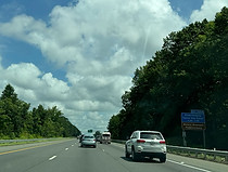
At mile marker 112.7, the trees in the median briefly abate. Photo taken 07-19-2025.

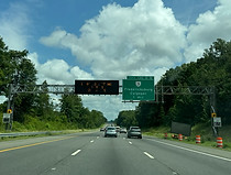
The next 16 miles of I-95 (up to around mile marker 129) are a variable speed limit zone, with speed limits displayed electronically. Photo taken 07-19-2025.

At mile marker 115, the speed limit at this moment was 70, the standard along this section. Photo taken 07-19-2025.

Paige Road (SR 605) soon passes overhead. Photo taken 07-19-2025.

I-95 now exits Caroline County and enters Spotsylvania County, and, according to Census definitions, transitions from Greater Richmond into the Washington, DC metropolitan area. Photo taken 07-19-2025.

Lake Anna State Park can be accessed from exit 118 up ahead. Photo taken 07-19-2025.

The Interstate then finds itself crossing the Matta River, one of the three sources of the Mattaponi River just to the east. Photo taken 07-19-2025.

Exit 118 intersects Mudd Tavern Road (SR 606) toward Thornburg and is a mile away. Photo taken 07-19-2025.

Exit 118 is just ahead on the right. Photo taken 07-19-2025.

Kalahari has a resort at exit 118, and the Dominion Raceway sprint car racing dirt track is also located beside the exit. Photo taken 07-19-2025.

Mudd Tavern's crossing of I-95 was reconstructed around 2020. Photo taken 07-19-2025.

After exit 118, there is I-95 reassurance. Photo taken 07-19-2025.

The Interstate soon crosses the Po River. Photo taken 07-19-2025.

The speed soon drops to 60 MPH. Photo taken 07-19-2025.

Then, with the speed limit down to 55, it passes under a service road. Photo taken 07-19-2025.

The highway then goes over the Ni River. Photo taken 07-19-2025.

The next overpass is Guinea Station Road (SR 607). Photo taken 07-19-2025.

The SR 630 exit in Stafford (140) is 18 miles and 17 minutes from this VMS. Photo taken 07-19-2025.

Massaponax Church Road (SR 608) then passes overhead. Photo taken 07-19-2025.

Lodging options at exit 126A are displayed ahead at right. Photo taken 07-19-2025.

Meanwhile, exit 130A a few miles further ahead can be used to reach downtown Fredericksburg. Photo taken 07-19-2025.

Exit 126B leads to the Spotsylvania station of Virginia Railway Express (VRE), the southern terminus (as of 2015) of the Fredericksburg Line. Photo taken 07-19-2025.

Exit 126B can also be taken to the Fredericksburg Area campus of Germanna Community College. Photo taken 07-19-2025.

The area of Spotsylvania Courthouse to the west can be reached from exit 126A. Photo taken 07-19-2025.

At this time, U.S. Route 17 (Mills Drive) passes over I-95 just before it joins the Interstate for a concurrency. Photo taken 07-19-2025.

A Spotsylvania County Visitors Center is off exit 126B. Photo taken 07-19-2025.

Exit 126A leads to northbound U.S. Route 1 (Patriot Highway) and Fredericksburg in half a mile. Photo taken 07-19-2025.

I-95 glides downward and curves left as it nears exit 126. Photo taken 07-19-2025.

After going back uphill the Interstate reaches exit 126A half a mile prior to exit 126B (US 1/US 17 south) toward Spotsylvania. Photo taken 07-19-2025.

The exit 126A gore. Photo taken 07-19-2025.

The Interstate then proceeds to cross US 1/17. Photo taken 07-19-2025.

Exit 126B then departs to US 1/17 south, and US 17 north is now marked together with I-95 north on guide signs. Photo taken 07-19-2025.

The exit 126B gore sign. Photo taken 07-19-2025.

Exit 126 is followed by an I-95/US 17 shield assembly. Photo taken 07-19-2025.

At mile marker 127, Virginia State Route 208 (Courthouse Road) passes overhead, without an interchange. Photo taken 07-19-2025.

The cities of Alexandria and Washington are currently 47 and 56 miles away. Photo taken 07-19-2025.

Historic Civil War battlefields can be reached from each leg of exit 130: the Fredericksburg off exit 130A, and the Chancellorsville and Wilderness off exit 130B. Photo taken 07-19-2025.

In the realm of higher education, the University of Mary Washington can be accessed from exit 130A, and the Locust Grove campus of Germanna Community College from exit 130B. Photo taken 07-19-2025.

The Fredericksburg stop of VRE, which doubles as an Amtrak station, in the heart of the city's downtown can be reached from exit 130A. Photo taken 07-19-2025.

A trinity of competing super-gas stations - Wawa, Sheetz and Royal Farms - are located across both ends of exit 130. Photo taken 07-19-2025.
Exit 130 intersects Virginia State Route 3, with control cities of Fredericksburg and Culpeper, in one mile. Photo taken 07-19-2025.

I-95 now enters Fredericksburg city limits. Photo taken 07-19-2025.
Exit 130A can be taken to a Fredericksburg tourist info center and Fredericksburg's historic downtown. Photo taken 07-19-2025.

Exit 130A to VA 3 east is ahead on the right, while exit 130B is ¼ mile away. Photo taken 07-19-2025.

The exit 130A gore sign. Photo taken 07-19-2025.

Exit 130B then departs for VA 3 west. Photo taken 07-19-2025.

The exit 130B gore sign. Photo taken 07-19-2025.

In one mile, a collector-distributor roadway leads to exit 133, where US 17 north leaves the Interstate and US 17 Business goes south toward Falmouth. Photo taken 07-19-2025.

A Stafford visitors center, Gari Melchers' Belmont and the Stafford campus of the University of Mary Washington are off exit 133. Photo taken 07-19-2025.

At right, the distances to each exit point along the C/D are displayed overhead. Photo taken 07-19-2025.

More I-95/US 17 shield assemblies line either side of the highway between exits. Photo taken 07-19-2025.

George Washington's Ferry Farm and Chatham Manor are also off exit 133. Photo taken 07-19-2025.

US 17's split at exit 133 commences in half a mile. Photo taken 07-19-2025.

Fall Hill Avenue (SR 639) crosses the Interstate as the exit nears. Photo taken 07-19-2025.

The connector to exit 133 lies ahead. Photo taken 07-19-2025.

The exit 133 gore sign. Photo taken 07-19-2025.

In two miles, I-95's median HOV express lanes begin, which last all the way to I-395's crossing of the Potomac River near the Pentagon in Arlington, about 47 miles to the north. Photo taken 07-19-2025.

I-95 goes downhill and then crosses the Rappahannock River, one of the tidal waterways forming Virginia's distinct eastern peninsulas, into Stafford County. Photo taken 07-19-2025.

The Rappahannock crossing was widened from two to four spans with the express lane extension in the early 2020s. Photo taken 07-19-2025.

Exit 133 proper is just past the top of this hill. Photo taken 07-19-2025.

There are solo I-95 shields as US 17 prepares to leave the Interstate. Photo taken 07-19-2025.

The highway crosses US 17/17 Business here. Photo taken 07-19-2025.

I-95's express lanes are reversible, and were pointed for southbound traffic at this time. Photo taken 07-19-2025.
