
The epzik8 Webpage
Interstate 95 north - Fredericksburg to Springfield

In the Falmouth area of Stafford County, Virginia, not far north of Fredericksburg, Interstate 95 north leaves behind exit 133 (U.S. Route 17 Business south/mainline US 17 north) and receives a set of collector/distributor lanes from that exit. In 2023, after more than four years of construction, the well-known express HOV lanes in I-95's median in Northern Virginia reached this exit, a further step to combat longstanding traffic congestion along this segment of I-95. Photo taken 04-28-2025.

At the Truslow Road overpass, the exit at Virginia State Route 234 in Dumfries (152) is 18 miles and 17 minutes away. Photo taken 04-28-2025.

A ramp to the express lanes is to the right. These lanes are reversible and are usually opened to northbound traffic during the morning rush hour, then switched for southbound traffic by the time of the afternoon and evening rush. Photo taken 04-28-2025.

The far-right northbound lane is now reserved for exit 136 at Centreport Parkway (SR 8900), which leads east to U.S. Route 1 and the Stafford Airport. Photo taken 04-28-2025.

A stone sound barrier lines the right side of the highway approaching the exit. Photo taken 04-28-2025.

At the Enon Road (SR 627) overpass, I-95 reaches exit 136, opened in 2005. Photo taken 04-28-2025.

The Interstate begins gliding downhill and curving to the right at the exit. Photo taken 04-28-2025.

Centreport Parkway then makes its overhead passage. Photo taken 04-28-2025.

To the right, a long onramp makes its way to the northbound lanes. Photo taken 04-28-2025.

I-95 then crosses the Potomac Creek, a tributary of the tidal namesake Potomac River. Photo taken 04-28-2025.

The speed limit is 65 miles per hour as the highway begins climbing uphill. Photo taken 04-28-2025.

At the crest of the hill, I-95 passes under American Legion Road (SR 628). Photo taken 04-28-2025.

Exit 140 with Courthouse Road (SR 630) toward county seat Stafford is a mile away. Photo taken 04-28-2025.

Food at exit 140 includes options as diverse as Publix and Sheetz. Photo taken 04-28-2025.
The Brooke station along the Fredericksburg line of the Virginia Railway Express (VRE) is off this exit. Photo taken 04-28-2025.

This exit also provides access to the Stafford Civil War Park. Photo taken 04-28-2025.

Exit 140 is straight ahead. It became a diverging diamond interchange (DDI) concurrent with the Fredericksburg HOV extension. Photo taken 04-28-2025.
The exit 140 gore sign. Photo taken 04-28-2025.

Courthouse Road has a two-span crossing over I-95. Photo taken 04-28-2025.

The Interstate then crosses a northbound HOV access lane. Photo taken 04-28-2025.

The next HOV entrance at Garrisonville is two miles past the north end of exit 140. Photo taken 04-28-2025.

A full set of services including camping and an "attraction" are located off exit 143 ahead. Photo taken 04-28-2025.

Exit 143, 1¼ miles ahead with control cities of Aquia and Garrisonville, has separate offramps to US 1 and Garrisonville Road (SR 610). A quarter-mile beforehand sits the HOV entrance, but it was closed at the time because it was oriented for southbound traffic. Photo taken 04-28-2025.

The blue service sign on the right lists the exit's purported "attractions" as a Hampton Inn and a Marriott Fairfield, though it could be that the lodging column was made too small for what ended up on the sign. Photo taken 04-28-2025.

Rather arbitrarily, a sign pops up listing Alexandria and Washington, DC as respectively 31 and 40 miles away. Photo taken 04-28-2025.

Another blue sign, dedicated solely to lodging, sees the Fairfield posted a second time for exit 143A. Photo taken 04-28-2025.

At the express entrance there is a northbound 95 directional sign. Photo taken 04-28-2025.

The express entrance is positioned just past exit 143A. For 9 years, this was the south end of the HOV lanes from 2014 until 2023. Photo taken 04-28-2025.

Exit 143B to Garrisonville follows. Photo taken 04-28-2025.

The exit 143B gore sign. Photo taken 04-28-2025.

One of Virginia's famous "Speed Limit Enforced by Aircraft" signs is after the exit. Photo taken 04-28-2025.

Alexandria and Washington now lie 28 and 37 miles away. Photo taken 04-28-2025.

The Interstate crosses Aquia Creek in-between exits. Photo taken 04-28-2025.

An express ramp to the forthcoming exit, serving Quantico, by way of I-95's main lanes is up ahead. Photo taken 04-28-2025.

An empty blue services sign is at the right approaching exit 148. Photo taken 04-28-2025.

At left, distances to a set of three express-exclusive exits are displayed overhead. Photo taken 04-28-2025.

There then appears a flyover ramp from I-95 south to the HOV lanes. Photo taken 04-28-2025.

Telegraph Road (SR 637) crosses the highway at the ¾ mile advance notice for exit 148, which directly serves the Marine Corps Base Quantico. Photo taken 04-28-2025.

Passing overhead here is the northbound express ramp to the main lanes, which becomes the lane for the northbound offramp of exit 148. Photo taken 04-28-2025.

Northbound drivers who just exited the HOV lanes may either exit up ahead or remain on the main northbound lanes. Photo taken 04-28-2025.

A few feet prior to the exit, I-95 crosses the Chopawamsic Creek from Stafford into Prince William County. Photo taken 04-28-2025.

The cross street at exit 148 is Russell Road. Photo taken 04-28-2025.

The bridge over Russell Road is here. Photo taken 04-28-2025.

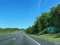
The next bit of signage states exit 150 can be used to access the Prince William Forest Park. Photo taken 04-28-2025.

Exit 150 intersects Fuller Road (SR 619) with control cities of Triangle and Quantico in one mile. Photo taken 04-28-2025.

The spire at the top of the National Museum of the Marine Corps is seen approaching the exit. Photo taken 04-28-2025.

VRE's Quantico station is also located off this exit. Photo taken 04-28-2025.

There is also signage for the Marine Corps museum before the exit. Photo taken 04-28-2025.

The interstate reaches exit 150 at a hillcrest. Photo taken 04-28-2025.

The northbound exit 150 ramp gore sign is currently missing. Photo taken 04-28-2025.

Fuller Road is passed over here. Photo taken 04-28-2025.

A truck rest area is located three miles away; it includes vending machines. Photo taken 04-28-2025.

I-95's southern exchange with I-495, at the Springfield Interchange, is 19 miles from this VMS; the travel time depends on the level of traffic congestion along the corridor. Photo taken 04-28-2025.

The next express entrance, at Dumfries, sits a mile away. Photo taken 04-28-2025.

Blue service signs begin to appear for exit 152, starting with lodging. Photo taken 04-28-2025.

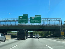
Exit 152 intersects Virginia State Route 234 and provides access to Dumfries and Manassas. Crossed ahead is Batestown Road (SR 629): formerly known as Mine Road in reference to a U.S.-government-spearheaded mining facility in the area, its name was reverted in 2021 in honor of Batestown, an early 19th-century community developed by freed African-American slaves. Photo taken 04-28-2025.

Exit 152B can be used to reach the Manassas Regional Airport. Photo taken 04-28-2025.

To the immediate east of exit 152A, VA 234 reaches its south end at US 1 just north of historic downtown Dumfries. Photo taken 04-28-2025.

Exit 152A immediately follows the Dumfries express entrance, the southern limit of the HOV lanes for 17 years, 1997 to 2014. Photo taken 04-28-2025.

Exit 152A also leads to Dumfries' Weems-Botts Museum, which was built and lived in by associates of George Washington. Photo taken 04-28-2025.

The exit 152A gore sign. Photo taken 04-28-2025.

The truck rest area, which includes a weigh station, is a mile away. Photo taken 04-28-2025.

Exit 152B, a cloverleaf ramp to VA 234 north, is on the other side of VA 234's overpass of the Interstate. This leads to the planned golfing community of Montclair. Photo taken 04-28-2025.

The exit 152B gore sign is inexplicably elongated with small text. Photo taken 04-28-2025.

A sign to the right, positioned as such for visibility to drivers entering from VA 234, posts HOV toll rates to I-495 17 miles away and the I-395 Pentagon exit 27 miles away, though these were blank at the time. Photo taken 04-28-2025.

As the truck rest area approaches, there is a car rest are two miles further north. Photo taken 04-28-2025.

The truck rest area entrance sign. Photo taken 04-28-2025.

A sign at the entrance points the way to the weigh station. Photo taken 04-28-2025.

I-95 will receive exiting truck traffic up ahead. Photo taken 04-28-2025.

The next express entrance is ahead on the left. Photo taken 04-28-2025.

As exit 156 nears, the speed limit will drop to 60 miles per hour. Photo taken 04-28-2025.

Ahead, the Potomac Town Center can be reached from exit 156A, and Potomac Mills from exits 156B or 158B. Photo taken 04-28-2025.

Exit 156 intersects Dale Boulevard (SR 784) toward Dale City and Rippon Landing in one mile. Half a mile prior sits the car rest area. Cardinal Drive passes overhead. Photo taken 04-28-2025.

The rest area entrance lies ahead after a wide curve to the left. Photo taken 04-28-2025.

The highway crosses Neabsco Creek in the meantime. Photo taken 04-28-2025.

The car rest area entrance. Photo taken 04-28-2025.

The Hylton Memorial Chapel and its events center are at exit 156B. Photo taken 04-28-2025.

A collector/distributor separates each ramp of exit 156 from the northbound carriageway. Photo taken 04-28-2025.

Potomac Mills (built by the same company as Arundel Mills south of Baltimore, Maryland), is marked as off the second right (156B). Photo taken 04-28-2025.

At exit 156, the express lanes have a separate ramp to Opitz Boulevard (SR 2000) and the Woodbridge campus of the Northern Virginia Community College is added for exit 156A. Photo taken 04-28-2025.

The exit 156A gore sign contains a VRE notation. Photo taken 04-28-2025.

The cloverleaf exit 156B is on the other side of this overpass. Photo taken 04-28-2025.

Before the main lanes receive traffic from SR 784, the express lanes have their ramp to Opitz Boulevard, which then passes over the Interstate. Photo taken 04-28-2025.

In one mile, an HOV ramp serves interests to the next three mainline exits. Photo taken 04-28-2025.

Exit 158A ahead intersects Virginia State Route 294 (Prince William Parkway) with control cities of Woodbridge and Manassas. Photo taken 04-28-2025.

Traffic from SR 784 finally enters the northbound carriageway to the right. Photo taken 04-28-2025.

The next northbound HOV access ramp flies overhead here. Photo taken 04-28-2025.

The through and exit lanes at exit 158 are outlined by this overhead sign assembly. Photo taken 04-28-2025.

Meanwhile, gas at exit 158B includes a competing Sheetz and Wawa. Photo taken 04-28-2025.

Alternate access to Potomac Mills is via exit 158B. The greened-out part of this sign used to say Strayer University, Woodbridge Campus. Photo taken 04-28-2025.

Exit 158 is straight ahead. VA 294 used to be a secondary route, SR 3000. Photo taken 04-28-2025.

The exit 158 gore sign. Photo taken 04-28-2025.

The Prince William Parkway crosses the Interstate here. Photo taken 04-28-2025.

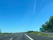
I-95 reassurance is provided between exits. Photo taken 04-28-2025.

One mile prior to exit 160 with Virginia State Route 123, toward Woodbridge and Occoquan, the speed limit drops to 55 miles per hour. Photo taken 04-28-2025.

Historic Occoquan and the Occoquan Bay National Wildlife Refuge can both be reached from exit 160. Photo taken 04-28-2025.

A park and ride for all types of vehicles is located at exit 160B. Photo taken 04-28-2025.

Mason Neck at the confluence of the Occoquan and Potomac rivers, which includes a state park, the Pohick Bay Golf Course and Gunston Hall, can be reached from the next two exits. Photo taken 04-28-2025.

Exit 160A is ahead, exit 160B following in ¼ mile. Photo taken 04-28-2025.

The exit 160A gore sign contains a VA 123 route marker, in case the preceding exit signs weren't clear enough. Photo taken 04-28-2025.
Exit 160B adds the planned community of Lake Ridge as an additional control city at the exit, and in ¾ mile, exit 161 will provide access to northbound U.S. Route 1, Fort Belvoir, and historic Mount Vernon. Photo taken 04-28-2025.

At exit 160B, the Interstate has a small but sweeping curve to the left. Photo taken 04-28-2025.

Between exits 160 and 161, I-95 uses the Purple Heart Bridge to cross the Occoquan River from Prince William into Fairfax County. Photo taken 04-28-2025.

This bridge tends to be one of the most congested spots along I-95 in Northern Virginia and in the D.C. metro area as a whole. Photo taken 04-28-2025.

Gunston Hall, a mid-18th-century house and plantation headquarters built for George Mason, is off exit 161. This and exit 163 can both also be used to reach the Lorton area. Photo taken 04-28-2025.

Exit 161 to US 1 north departs ahead at right. Photo taken 04-28-2025.

There is a 13-foot, 4-inch vertical clearance limit for large trucks and similar vehicles along US 1. Photo taken 04-28-2025.

The exit 161 gore sign. US 1 (Richmond Highway) parallels I-95 to the east from Fredericksburg to Lorton, where it turns eastward to continue following the course of the Potomac. Photo taken 04-28-2025.

The northbound carriageway proceeds over the ramp from I-95 south to US 1 south. Photo taken 04-28-2025.

Eventually, the highway receives traffic entering from northbound US 1. Photo taken 04-28-2025.

After exit 161, the Interstate straightens out, essentially positioning itself due north. Photo taken 04-28-2025.

Blue service signs are now appearing for exit 163. Photo taken 04-28-2025.

Exit 163 intersects SR 642 (Lorton Road) toward Lorton in one mile. Photo taken 04-28-2025.

Another VRE station is off exit 163. Photo taken 04-28-2025.

This exit also leads to the northern stop of Amtrak's Auto Train, whose other end is at Sanford, Florida. Photo taken 04-28-2025.

Interests to Pohick Bay Park may use this exit. Photo taken 04-28-2025.

Exit 163 lies ahead. Photo taken 04-28-2025.

After exit 163, the Interstate curves right and crosses Pohick Creek. Photo taken 04-28-2025.

The next express entrance is a mile away. Photo taken 04-28-2025.

As an express exit to Boudinot Drive to the Fairfax County Parkway nears, there is 4 miles' advance notice for the diversion of I-95 north onto the Capital Beltway. Photo taken 04-28-2025.

Next, the Interstate crosses Accotink Creek right beside Accotink Park. Photo taken 04-28-2025.

Highlighting its influence on the corridor, I-95 north is stated at right to go toward New York City and New Jersey, well over 200 miles away, with D.C., Baltimore and Philadelphia all sandwiched in between. Photo taken 04-28-2025.

Exit 166A ahead goes to the National Museum of the United States Army at Fort Belvoir. Photo taken 04-28-2025.

Meanwhile, off exit 169A further along is the Springfield Mall. Photo taken 04-28-2025.

The next express entrance is seen at left. Photo taken 04-28-2025.

The express exit for Boudinot Drive, which connects those lanes with the Fairfax County Parkway, is just ahead. To the right of the exit sign, Edsall Drive reflects the upcoming transition to I-395. Photo taken 04-28-2025.

Of the two offramps at exit 166 with the Fairfax County Parkway (Virginia State Route 286), exit 166A leads toward Newington and Fort Belvoir, and exit 166B serves interests to Backlick Road and Fullerton Road. Photo taken 04-28-2025.
Of the two offramps at exit 166 with the Fairfax County Parkway (Virginia State Route 286), exit 166A leads toward Newington and Fort Belvoir, and exit 166B serves interests to Backlick Road and Fullerton Road. Photo taken 04-28-2025.

Exit 166A precedes 166B by ¼ mile. Photo taken 04-28-2025.

The highway now descends upon exit 166B. A separate offramp and connector lead from the left side of this overpass to Fullerton Road. Photo taken 04-28-2025.

The express ramp to the next three mainline exits, including the I-395/495 exchange, is ahead. Photo taken 04-28-2025.

In one mile, exit 169 will intersect SR 644 (Keene Mill Road) toward Franconia and Springfield. Photo taken 04-28-2025.

Washington Metro's Franconia-Springfield station, the southwestern terminus of the Blue Line, can be reached from exit 169A. Photo taken 04-28-2025.

Exit 170 - the Springfield Interchange - is where I-95 meets Interstates 395 and 495. There, northbound I-95 joins the outer loop (east) of I-495, the Capital Beltway, for a trip to the east of Washington, DC. Photo taken 04-28-2025.

The inner loop of I-495 leads to Interstates 66 and 270 and, via the Dulles Access Road, the Washington Dulles Airport some miles to the west. Photo taken 04-28-2025.

The express lanes have an exit to Virginia State Route 289 (Franconia-Springfield Parkway) prior to the Springfield Interchange. Photo taken 04-28-2025.

A collector-distributor to exit 169 parts with the northbound lanes ahead. Photo taken 04-28-2025.

A pedestrian footbridge passes overhead at the exit 169 gore. Photo taken 04-28-2025.

To the left, before exit 169 proper, the express exit ramp is seen reaching VA 289. Photo taken 04-28-2025.

This overhead sign points the way to various directions and control cities at exit 170: Baltimore for I-95 north, Washington for I-395 north, and Tysons Corner for the solo inner loop of I-495. Photo taken 04-28-2025.

A notorious fixture among D.C.-area highways, the Springfield Interchange - once colloquially known as the Mixing Bowl, for the tricky lane changes required to perform most lane movements in its original configuration - was reconstructed and expanded with several new ramps and lane configurations in a lengthy project lasting from 1999 all the way until 2007. This work also affected exit 169. Photo taken 04-28-2025.
