
The epzik8 Webpage
Interstate 395 north - Virginia

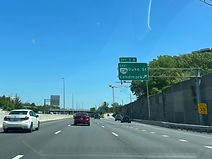
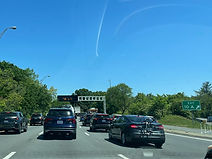
In Springfield, Fairfax County, Virginia, Interstate 395 is preparing to split from a ramp leading to the outer loop of Interstate 495 (Capital Beltway) after departing from northbound Interstate 95. Photo taken 04-28-2025.

The HOV express ramp leading from northbound Interstate 95 to the outer loop of I-95/495 is on the left. Photo taken 04-28-2025.

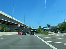
More flyover ramps, including from the outer loop of 495 to I-95 south, are seen here. Photo taken 04-28-2025.

Finally, I-95 goes off overhead to the right to join the Beltway, and northbound I-395 has ¾ mile advance signage for exit 2 at Edsall Road (SR 648). Photo taken 04-28-2025.

At right, a ramp from the inner loop of the Beltway reaches the northbound lanes, while at right, an HOV sign states the distances to the next three HOV exits. Photo taken 04-28-2025.

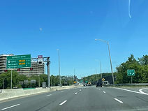
Arlington is 9 miles from the next exit 2 advance sign. Photo taken 04-28-2025.

Exit 2A to Edsall Road east is ahead; exit 2B follows in ¼ mile. Photo taken 04-28-2025.

Signage for exit 2B includes a further I-395 through lane diagram. Photo taken 04-28-2025.

Below exit 2B, a flyover ramp goes from Edsall Road east to I-395 north. Photo taken 04-28-2025.

After Edsall Road sits northbound express access to mainline I-395. Photo taken 04-28-2025.

Exit 3, which intersects Virginia State Route 236 (Duke Street/Little River Turnpike), is a mile away. Photo taken 04-28-2025.

The HOV flyover ramp sits above a bridge over Turkeycock Run. Photo taken 04-28-2025.

Just prior to exit 3, I-395 leaves Fairfax County for the western city of Alexandria. Photo taken 04-28-2025.
Exit 3A leads to VA 236 east and the Alexandria area of Landmark. Photo taken 04-28-2025.

Exit 3B's control city is Lincolnia. Photo taken 04-28-2025.

Exit 4 at Seminary Road is a mile past the onramp from VA 236. Photo taken 04-28-2025.

Access from the HOV lanes for Seminary Road is a quarter-mile before the proper exit ramp from the mainline carriageway. Photo taken 04-28-2025.

Exit 4 serves the Alexandria campus of the Northern Virginia Community College (NVCC). Photo taken 04-28-2025.

This exit additionally leads to the Fort Ward Museum and Park, which is located on Braddock Road and backs to Van Dorn Street. Photo taken 04-28-2025.

There are two exit lanes for Seminary Road from I-395 north. Photo taken 04-28-2025.
The exit 4 gore sign. Seminary Road goes southeast from Bailey's Crossroads to Quaker Lane, where it becomes Janney's Lane. Photo taken 04-28-2025.

Exit 5 will intersect Virginia State Route 7 (King Street) in ¾ mile as Seminary Road passes overhead, here the main drag through the Beauregard section of west Alexandria. Photo taken 04-28-2025.

Alexandria shows off its walkability by putting this pedestrian walkway between each direction of Seminary. Photo taken 04-28-2025.

The northbound onramp from Seminary, like other interchanges along I-395, is metered with a "one car per green" rule to mitigate unsafe merging situations during periods of heavy traffic. Photo taken 04-28-2025.

I-395 then passes over Braddock Road. No access is provided from the Interstate to Braddock, which more or less divides south and north Alexandria and ends up in Old Town West about 13 blocks west of the Potomac shoreline. Photo taken 04-28-2025.

The city's Old Town can be reached from exit 5 along with a tourist info center. Photo taken 04-28-2025.

Unlike at Seminary Road, there is only one northbound exit lane for King Street. Photo taken 04-28-2025.

Exit 5 is located near the eastern terminus of VA 7, which links Winchester in Virginia's mountain northwest to Alexandria by way of Loudoun County's mostly densely developed areas and Falls Church. Photo taken 04-28-2025.

Exit 6, serving Shirlington, is ¾ mile away. Photo taken 04-28-2025.

After it passes under King Street, the Interstate makes its transition from Alexandria into Arlington County. Photo taken 04-28-2025.

Arlington is marked as being via any of the next 7 exits. Though implied in print as a consolidated city-county, Arlington is actually an unincorporated census-designated place (CDP) that is coterminous with its namesake county - thus, there is no actual Arlington city government. Photo taken 04-28-2025.

There is a second overhead sign pointing to exit 6 closer to the beginning of the offramp. Photo taken 04-28-2025.

There are separate signs for Shirlington Road and Quaker Lane along the exit 6 collector-distributor. Meanwhile, along the Interstate proper, Marymount University in northwest Arlington is billed to the second right movement at the next exit. Photo taken 04-28-2025.

The centerpiece of exit 6 is effectively a big roundabout, Shirlington Circle. Photo taken 04-28-2025.

Exit 7 facilitates access to each direction of Virginia State Route 120 (Glebe Road) in the next half-mile span. Photo taken 04-28-2025.

In the meantime, the Interstate passes over Four Mile Run, a Potomac tributary. Photo taken 04-28-2025.

Exit 7A sits to the right. Photo taken 04-28-2025.

Exit 7B contains accompanying signage for Marymount. Photo taken 04-28-2025.
The exit 7B gore sign. Photo taken 04-28-2025.

Exit 7 is followed by I-395 reassurance. Photo taken 04-28-2025.

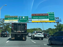
Exit 8, at Virginia State Route 27 (Washington Boulevard), is half a mile ahead and is marked as leading to the Pentagon, Arlington National Cemetery, and the Rosslyn area of north Arlington. Express signage for exit 8 mentions the Arlington Memorial Bridge. Photo taken 04-28-2025.

Exit 8A serves Henderson Hall of the U.S. Air Force's Joint Base Myer. The Air Force also has a memorial located due south of the Arlington Cemetery grounds, reachable from exit 8B. Photo taken 04-28-2025.

At the next overhead gantry, exit 8A contains an added notation for Virginia State Route 244 (Columbia Pike). Photo taken 04-28-2025.

Exit 8A has two lanes set aside for it as seen at right. Photo taken 04-28-2025.

Approaching exit 8, I-395 passes over the access road to Arlington's Army Navy Country Club. Photo taken 04-28-2025.

Exit 8B, which serves interests to the Pentagon/Rosslyn areas, sits ahead. Photo taken 04-28-2025.

At exit 8B, I-395 begins approaching exit 8C, which leads to southbound U.S. Route 1 (Richmond Highway) toward Pentagon City, Crystal City and the Washington Reagan National Airport (DCA). Photo taken 04-28-2025.

The exit 8B gore sign. Photo taken 04-28-2025.

As the Interstate turns northeast for exit 8C, the Pentagon and the Washington Monument become visible. Photo taken 04-28-2025.

Ahead of exit 8C, there are separate express exits for the Pentagon and Pentagon City. Photo taken 04-28-2025.

The highway continues curving right at exit 8C. Photo taken 04-28-2025.

The Pentagon City express exit is almost within sight of the Interstate's crossing of US 1. The movement between I-395 north and US 1 south is partially made by way of Army Navy Drive. Photo taken 04-28-2025.

The Blue Line of the Washington Metro slips under I-395 at this crossing, just after its split from the Yellow Line and about a block east of the Fashion Centre at Pentagon City. The Pentagon and Pentagon City also each have Metro stops in quick succession in this area. Photo taken 04-28-2025.

I-395's express lanes now come to an end after approximately 46 miles, closing a journey that begins along I-95 at exit 133 in Stafford County, north of Fredericksburg. Photo taken 04-28-2025.

US 1 has begun an overlap with I-395, and the highway approaches exit 10A with the southbound George Washington Parkway, with access to Reagan National and Boundary Channel Drive. Photo taken 04-28-2025.
Exit 10B leads to the northbound GW Parkway and the Arlington bridge. As a National Park Service facility, large trucks are prohibited on the Parkway. Photo taken 04-28-2025.
Exit 10A is a rather common spot for backups to begin on I-395 north heading into DC. Photo taken 04-28-2025.

Exit 10B then leaves the Interstate to the left to the northbound GW Parkway, which makes its way to I-495 beside Turkey Run Park on the south banks of the Parkway, passing by certain government facilities in the process. Photo taken 04-28-2025.

I-395 crosses into the District of Columbia along one of the spans of the 14th Street Bridge complex over the Potomac River. These crossings also include ones carrying Amtrak/VRE and Metro Yellow Line trains over the river. Photo taken 04-28-2025.
