
The epzik8 Webpage
Interstate 95/495 outer loop - Wilson Bridge to College Park

Interstate 95/495 (Capital Beltway) uses the Woodrow Wilson Bridge, a drawbridge to cross the Potomac River from Virginia into Maryland. A reconstructed Wilson Bridge opened in 2006 with a higher vertical clearance to allow the drawbridge to have to open less often. Photo taken 04-29-2025.

In Alexandria, Virginia a few miles behind, the outer loop of the Beltway splits into thru and local lanes. A sign over the thru lanes displays three major exits encountered during the remainder of I-95's time on the Beltway, including the highways' split in College Park. Over the local lanes, interests to sections of the National Harbor complex beside the Potomac are directed to two different exits, 2A and 3A. Photo taken 04-29-2025.

The control tower for the drawbridge is situated in the middle of the bridge. Photo taken 04-29-2025.

The first exit in Maryland, accessible only from the local lanes, is exit 2 with Interstate 295, marked as leading to Washington, DC and National Harbor. From the thru lanes, exit 3 leads to Maryland Route 210 (Indian Head Highway) with control cities of Forest Heights and Indian Head. It is possible to get straight from I-295 to MD 210 and vice versa by way of ramps connecting them. Photo taken 04-29-2025.

A Maryland welcome sign is near the end of the bridge. The Beltway officially enters the District of Columbia near its southern tip for 0.11 miles, which is not acknowledged in the field. Photo taken 04-29-2025.

The Woodrow Wilson Bridge Trail goes over the bridge as it ends and the local lanes come upon exit 2. Photo taken 04-29-2025.

Just feet after exit 2, the long offramp for exit 3 to MD 210 begins at the thru lanes. Photo taken 04-29-2025.
The exit 3 gore sign. Photo taken 04-29-2025.

Construction during the late 2000s into the early 2010s resulted in many flyover ramps being added to exits 2 and 3, like these ones. Photo taken 04-29-2025.

The ramp from I-295 south to the outer loop of the Beltway passes overhead here. Photo taken 04-29-2025.
Ahead, the Interstate crosses an onramp from the western lot of National Harbor to the inner loop of the Beltway. Photo taken 04-29-2025.

From the local lanes, exit 3B to MD 210 north is a mile away. Photo taken 04-29-2025.

The ramp from MD 210 north to the inner loop is in the distance. Photo taken 04-29-2025.

At right, the local lanes are approaching exit 3B. Photo taken 04-29-2025.

Bald Eagle Road passes overhead in the meantime. Photo taken 04-29-2025.

Exit 3B is on the other side of MD 210's crossing of the Beltway. North of here, MD 210 runs to southeast D.C. where it becomes South Capitol Street. Photo taken 04-29-2025.

Exit 4 with Maryland Route 414 (St. Barnabas Road) toward Oxon Hill and Marlow Heights is in one mile. Photo taken 04-29-2025.

After curving right, the Interstate crosses Livingston Road. Photo taken 04-29-2025.

There are then I-95 and 495 reassurance markers. Photo taken 04-29-2025.

Exit 4A to MD 414 west and Oxon Hill is on the right. Photo taken 04-29-2025.

The highway crosses MD 414 before reaching exit 4B. Photo taken 04-29-2025.

As it receives the onramp from MD 414, the Interstate curves left. Photo taken 04-29-2025.

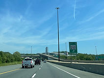
After the highway straightens out, a variable message sign displays the times and distances to U.S. Route 50 and the I-95 split. Photo taken 04-29-2025.

The BWI Airport closer to Baltimore can be reached from exit 22A, several miles away. Photo taken 04-29-2025.

In one mile, exit 7 will intersect Maryland Route 5 (Branch Avenue) with control cities of Waldorf and Silver Hill. Exit 7B can be used to reach the Branch Avenue station - the southern terminus of Washington Metro's Green Line, which in turn can be taken to Nationals Park of MLB's Washington Nationals near D.C.'s Navy Yard. Photo taken 04-29-2025.

Tourist sites along Southern Maryland's Potomac Corridor can be reached from exit 7A. Photo taken 04-29-2025.

Driver services are located off each part of exit 7. Photo taken 04-29-2025.

Exit 7A is ¼ mile before exit 7B. Photo taken 04-29-2025.

The ramp from the inner loop of the Beltway to MD 5 south is a flyover as seen here. At right, a cloverleaf onramp from MD 5 south reaches the outer loop. Photo taken 04-29-2025.

The Interstate takes time to pass over MD 5 prior to exit 7B. Photo taken 04-29-2025.

Exit 7B departs to MD 5 north to the right. Photo taken 04-29-2025.

Each of the next two exit ramps serves different components of the area's Joint Base Andrews: the main gate (9) and the delivery entrance (11A). Photo taken 04-29-2025.

Exit 9 intersects Maryland Route 337 (Allentown Road), which serves Andrews and the adjacent town of Morningside, in one mile. Even with the current Joint Base wording, area highway signs still bill Andrews as an Air Force Base. Photo taken 04-29-2025.

Auth Road zips over the Beltway before it reaches exit 9. Photo taken 04-29-2025.

Exit 9 is ahead at right. Photo taken 04-29-2025.

As the Interstate crosses MD 337, a Navy/Air Force water tower at Andrews is seen. Photo taken 04-29-2025.

One mile away, I-95/495 will intersect Maryland Route 4 (Pennsylvania Avenue) at exit 11, which bears control cities of P.G. county seat Upper Marlboro and Washington. Photo taken 04-29-2025.

What Maryland designates the Western Chesapeake Shore, and the Patuxent Corridor of tourism in Southern Maryland, can be reached via exit 11A. Among the accessed properties are the Jug Bay Natural Area of the Patuxent River Park in the Upper Marlboro area. Photo taken 04-29-2025.

The Beltway now crosses over the National Park Service-maintained Suitland Parkway, which links the Congress Heights section of southeast D.C. with the north edge of Joint Base Andrews via the namesake community of Suitland. Photo taken 04-29-2025.

A close-up of the Suitland Parkway bridge. Photo taken 04-29-2025.

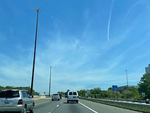
Between exits, I-95/495 reassurance shields are posted on the right. Photo taken 04-29-2025.

The "L" barrack of the Maryland State Police in Forestville can be reached from exit 11B, as can the community of District Heights. Photo taken 04-29-2025.

At the Beltway, each direction of MD 4 bears two cardinal names, in all likelihood due to its orientation as a whole. Exit 11A thus leads to "south-east" MD 4. Photo taken 04-29-2025.

Soon afterward, exit 11B makes its way to "north/west" MD 4, though MD 4 definitively runs east-west here and so the "north" is not necessarily needed. Photo taken 04-29-2025.

The Beltway glides downhill after receiving the onramp from westbound MD 4. Photo taken 04-29-2025.

The next three exits, starting with Ritchie-Marlboro Road, are displayed by this partially obscured sign in the median. Photo taken 04-29-2025.

D'Arcy Road subsequently passes overhead. Photo taken 04-29-2025.

Exit 13 intersects Ritchie-Marlboro Road, with control cities Capitol Heights and Upper Marlboro, in half a mile. Each side of the interchange contains roundabouts at Ritchie-Marlboro. Photo taken 04-29-2025.

The Interstate proceeds to cross Ritchie-Marlboro Road, which just to the west becomes Walker Mill Road. Photo taken 04-29-2025.

An older variable message sign displays the travel times to the Baltimore-Washington Parkway and the I-95 split. Photo taken 04-09-2025.

The next three exits all lead to Northwest Stadium, formerly FedExField - the home stadium of the NFL's Washington Commanders, formerly the Football Team, formerly the Redskins. Photo taken 04-09-2025.

Exit 15, a mile away, intersects Maryland Route 214 which has control cities of Largo and Seat Pleasant. Photo taken 04-09-2025.

One mile after exit 15 comes exit 16, at Medical Center Drive. Photo taken 04-09-2025.

The highway passes over MD 214/Central Avenue - a continuation of East Capitol Street, the line between northeast and southeast D.C. Photo taken 04-09-2025.

At right, the outer loop picks up an onramp from MD 214. Photo taken 04-09-2025.

After exit 16, exit 17 will meet Maryland Route 202 (Landover Road) which runs between Upper Marlboro and Bladensburg. Photo taken 04-09-2025.

The Senator Decatur "Bucky" Trotter Memorial Bridge then carries the Blue Line of the Washington Metro over the Beltway. Trotter was a member of Metro's Board of Directors later in his life, and died in 2004, the same year the eastern extension of the Blue Line to Largo opened. Photo taken 04-09-2025.

I-95/495 reassurance precedes exit 16. Photo taken 04-09-2025.

Originally known as Arena Drive and built in 1997 to serve and coincide with the opening of the Landover football stadium, Medical Center Drive was renamed as such in 2023 for the UM Capital Region Medical Center. Photo taken 04-09-2025.

The exit 16 gore sign. To the west, Medical Center Drive becomes Bishop Peebles Drive which leads straight into the eastern entrance of Northwest Stadium. A distance to the east, it becomes Lake Arbor Way, then Kettering Drive, serving each respective namesake community. Photo taken 04-09-2025.

The outer loop's lanes are about to divide again, but this time all lanes are thru, and only the right lanes have a second function as local lanes from which the MD 202 exit is accessed. Photo taken 04-09-2025.

Driver services are available at exit 17. Photo taken 04-09-2025.

The right lanes, with no physical barrier separating them from the left lanes, come upon exit 17. Photo taken 04-09-2025.

MD 202 passes overhead here. Photo taken 04-09-2025.

The left and right lanes of the highway will unite up ahead. Photo taken 04-09-2025.

Near mile marker 18, there is another reminder of BWI Marshall being reachable from exit 22A (B-W Parkway north). Photo taken 04-09-2025.

One mile away, at exit 19, I-95/495 has an interchange with U.S. Route 50, the highway running directly between Annapolis and Washington. Photo taken 04-09-2025.

The area of Bowie can be reached from exit 19A (US 50 east), and from 19B, one can reach the New Carrollton train station (MARC/limited Amtrak/Metro Orange Line). Photo taken 04-09-2025.

Baseball fans coming from the east can reach Nats Park by taking the Orange Line from here to the Capitol South station in southeast D.C. Photo taken 04-09-2025.

Half a mile south of exit 19, the Beltway passes under Ardwick/Ardmore Road. Photo taken 04-09-2025.

Exit 19A leads to eastbound US 50 and Annapolis, the capital of Maryland, to the right. The blank space to the left of the US 50 shield on this exit sign reflects the status of US 50 from this interchange to Annapolis as the secret Interstate 595. This part of US 50 was upgraded to Interstate highway standards in the 1990s, but upon completion, the State Highway Administration decided against signing I-595 along the corridor because they felt US 50 would make it superfluous. Photo taken 04-09-2025.

One mile past exit 19B, the Beltway meets Maryland Route 450 (Annapolis Road) toward Lanham and Bladensburg at exit 20. Photo taken 04-09-2025.

US 50 and several ramps of the interchange proceed overhead. Photo taken 04-09-2025.

Traffic from both directions of US 50 enters the outer loop at right. Photo taken 04-09-2025.

In the distance, half a mile from exit 20, a ramp from US 50 west to the New Carrollton station via Garden City Drive flies overhead. Photo taken 04-09-2025.

A subsequent advance sign for MD 450 east is missing an exit tab. Photo taken 04-09-2025.

Approaching exit 20, the Interstate crosses over Amtrak's Northeast Corridor, which gives New Carrollton its MARC and Amtrak service. Photo taken 04-09-2025.

Each ramp of exit 20 is ¼ mile apart. Photo taken 04-09-2025.

Exit 20A is quickly followed by exit 20B. Photo taken 04-09-2025.

After exit 20, the distances to the B-W Parkway, the I-95 split, and I-270 are displayed at right. Photo taken 04-29-2025.

Up ahead, exit 23 can be used to reach the Upper Anacostia Corridor. Photo taken 04-09-2025.

Good Luck Road is passed over just after mile marker 21. Photo taken 04-09-2025.

In one mile, I-95/495 intersects the Baltimore-Washington Parkway at exit 22. Photo taken 04-09-2025.

The status of this segment of the Parkway as an unsigned National Park Service facility likely drives the content of this "TO ROUTE 295" sign: to the north, the Parkway eventually becomes MD 295 once SHA assumes control of it, while to the south, it leads into DC 295. Photo taken 04-09-2025.

Exit 22A provides Beltway traffic with movements to Maryland Route 193 (Greenbelt Road) and NASA's Goddard Space Center. Photo taken 04-09-2025.

The Park Service does not allow trucks in either direction of its segment of the Parkway. Meanwhile, at exit 22A, there is half-mile advance signage for exit 23, Maryland Route 201 (Kenilworth Avenue) toward Bladensburg and Greenbelt. Photo taken 04-09-2025.

The University of Maryland campus in College Park, including SECU Stadium and Xfinity Center - the respective homes of Terrapins football and basketball - can be reached from exit 23, by taking MD 201 south to MD 193 west. Photo taken 04-30-2025.

The next I-495/95 shield assembly contains an "outer loop" notation at the bottom. Photo taken 04-30-2025.

Exit 23 sits just ahead. Continuing the name of Kenilworth Avenue beyond northeast D.C., MD 201 begins at the same interchange as the B-W Parkway near Cheverly, winds its way through Bladensburg and Riverdale, and, as Edmonston Road, ends up at Powder Mill Road outside of Beltsville. Photo taken 04-30-2025.

A cloverleaf onramp enters the outer loop from MD 201 north before MD 201 crosses overhead. Photo taken 04-30-2025.

The next overpass is Cherrywood Lane. Photo taken 04-30-2025.

One mile away, exit 25 intersects U.S. Route 1 (Baltimore Avenue) which has control cities of Laurel and College Park. Photo taken 04-30-2025.

The inner loop has its own exit (24) to the Greenbelt Metro station, the northern terminus of the Green Line. Entry to the Beltway is outer loop only; other traffic must use the station's main entrance at Cherrywood Lane. Photo taken 04-30-2025.

The split of northbound I-95 from the Beltway is two miles away. Photo taken 04-30-2025.

The outer loop receives Greenbelt metro traffic at right. Photo taken 04-30-2025.

The Interstate then crosses MARC's Camden Line along which the Green Line runs for its northernmost few miles. Photo taken 04-30-2025.

Beltsville to the north can be reached from exit 25, which is also another access point for the University of Maryland. Photo taken 04-30-2025.

The "Q" barrack of the Maryland State Police in College Park can be reached from this exit, as can the Beltsville branch of the Motor Vehicle Administration (MVA). Photo taken 04-30-2025.

Before exit 25 sits an aging bridge over Rhode Island Avenue. Photo taken 04-30-2025.

This overhead sign points the way to exit 25. Photo taken 04-30-2025.

The I-95 split is now a mile away. Photo taken 04-30-2025.

The Beltway then crosses Anacostia River tributary the Little Paint Branch. Photo taken 04-30-2025.

Of the six lanes forming the outer loop at this point, three are set aside for I-495 through traffic alone, two for northbound I-95 alone, and one (fourth from left) from which either movement can be made. Photo taken 04-30-2025.

This overpass right before the split carries Cherry Hill Road over the Beltway. Photo taken 04-30-2025.

The two Interstates now diverge, I-495 toward Montgomery County's inner ring and I-95 toward Baltimore. Photo taken 04-30-2025.