
The epzik8 Webpage
D.C. Route 295 north

Picking up where Interstate 295 leaves off at the Interstate 695 (Southeast Freeway) interchange, D.C. Route 295 - the only per se "district route" in the city of Washington - heads north as the Anacostia Freeway toward exit 1, with Pennsylvania Avenue. The eastbound leg of this interchange serves interests to Maryland's Joint Base Andrews. Photo taken 04-28-2025.

The entirety of DC 295 north is well-marked as leading to U.S. Route 50 just over the Maryland line. Photo taken 04-28-2025.

The gore sign for exit 1A. Photo taken 04-28-2025.

DC 295 crosses Pennsylvania Avenue before exit 1B. In the westbound direction, the White House is addressed to Pennsylvania Avenue but does not sit along the same roadway. Photo taken 04-28-2025.

At right, DC 295 collects traffic that just left Pennsylvania Avenue. Photo taken 04-28-2025.

The route curves left, and there is then DC 295 signage. Photo taken 04-28-2025.

A subsequent pair of route shields reaffirms this direction of the highway as leading toward I-95 north and US 50. Photo taken 04-28-2025.

The highway then crosses over a CSX railway. Photo taken 04-28-2025.

At the end of the CSX viaduct, DC 295 reaches mile marker 7, which is a continuation of I-295's mile markers. Photo taken 04-28-2025.

At this point, DC 295 reaches East Capitol Street, which is only accessible from the southbound carriageway, taking it into northeast D.C. Photo taken 04-28-2025.

DC 295's crossing of East Capitol Street takes it into northeast Washington, and it changes names to the Kenilworth Avenue Freeway after the street it was built over in the latter half of the 1950s. Photo taken 04-28-2025.

Soon after entering northeast D.C., the highway's median becomes a concrete barrier topped with a chain-link fence and streetlights. Photo taken 04-28-2025.
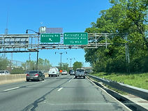
A northbound left exit onto Benning Road leads toward the abandoned RFK Stadium, which once hosted then-Washington Redskins football, D.C. United soccer, and Washington Nationals baseball for three seasons while Nationals Park was being built near the Navy Yard in southeast D.C. Meanwhile, another exit half a mile away leads to Burroughs Avenue and Minnesota Avenue. Photo taken 04-28-2025.

Benning Road now passes overhead. Photo taken 04-28-2025.

Then, the Orange Line of the Washington Metro passes overhead (one of its pillars is seen at far right), then begins paralleling DC 295 and soon reaches the Minnesota Avenue station. Photo taken 04-28-2025.

Beside the Metro station, a pedestrian footbridge connects it to Kenilworth Terrace. Photo taken 04-28-2025.

The Burroughs/Minnesota exit ramp is up ahead. Photo taken 04-28-2025.

DC 295 crosses over Burroughs Avenue, which to the left becomes Deane Avenue and goes into the Kenilworth Aquatic Gardens. Photo taken 04-28-2025.

The route picks up an onramp from the northbound Kenilworth Avenue feeder road approaching Polk Street. Photo taken 04-28-2025.

Another pedestrian walkway passes over the highway, its west end tying in with Lane Place in the Eastland Gardens subdivision. Photo taken 04-28-2025.

The slip ramp to Polk Street via a few feet of Kenilworth Avenue is at right. Photo taken 04-28-2025.

Half a mile from the US 50 interchange, there is an offramp to Quarles Street and Eastern Avenue. Photo taken 04-28-2025.

The US 50 junction is also the southern terminus of the Baltimore-Washington Parkway, which provides the remainder of the connection to I-95 at the Capital Beltway's exit 22. Photo taken 04-28-2025.

The highway passes under Eastern Avenue into Prince George's County, Maryland and officially becomes Maryland Route 201, though this is unacknowledged. Photo taken 04-28-2025.

At the next overhead sign, the directional tab for US 50 east toward Maryland state capital Annapolis is missing. Photo taken 04-28-2025.

Approaching the interchange, the highway crosses Amtrak's Northeast Corridor rail line. MARC's Penn Line service runs along the corridor here. Photo taken 04-28-2025.

US 50 continues west into D.C. as New York Avenue, the offramp to which is ¼ mile away. Photo taken 04-28-2025.
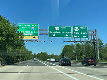
As the Baltimore-Washington Parkway begins just past US 50, MD 201 diverges to the right as Kenilworth Avenue, passing through the areas of Bladensburg and Riverdale before reaching the Capital Beltway. Photo taken 04-28-2025.
