
The epzik8 Webpage
Baltimore-Washington Parkway north - US 50 to Maryland Route 175

Just over the District of Columbia line, in a gray area of Prince George's County, Maryland (variously described as Cheverly, Landover or Capitol Heights), northbound traffic leaving the District comes upon an interchange between U.S. Route 50, the Baltimore-Washington Parkway, and Maryland Route 201 (Kenilworth Avenue), the last of which is the official highway designation at this spot. Photo taken 04-28-2025.

Traffic headed onto the B-W Parkway exits to the left and passes over Kenilworth Avenue. Photo taken 04-28-2025.

The speed limit for right now is 45 miles per hour. Photo taken 04-28-2025.

This portion of the Parkway is maintained by the National Park Service, and a modernization project in the early 2020s added mile markers to the NPS section of the parkway. Though not signed in the field, Maryland's State Highway Administration considers this part of Maryland Route 295. Photo taken 04-28-2025.

An interchange with Maryland Route 202 with control cities of Bladensburg and Cheverly is half a mile ahead. Photo taken 04-28-2025.

The highway curves slight right in the meantime. Photo taken 04-28-2025.

The offramp to MD 202 is off to the far right. Photo taken 04-28-2025.

Immediately afterward, the Parkway intersects Maryland Route 450. As a historic alignment of US 50, MD 450, in addition to also connecting to Bladensburg, has a control city of Annapolis, the state capital, where it directly reaches the State House. In the meantime, MD 450 passes through Lanham-Seabrook and the north side of the modern portion of Bowie. Photo taken 04-28-2025.

Off-photo to the right beside the Parkway's northbound onramp from MD 450 is Landover's Capital Plaza shopping center. Photo taken 04-28-2025.

Stone walls and overpasses like this one are a defining feature of the National Park portion of the Parkway. Photo taken 04-28-2025.

Following these two interchange, the highway makes its way into a cluster of trees. Photo taken 04-28-2025.

At left in the median, drivers finally get a formal welcome to the Parkway. Both portions are dedicated to the late Congressional representative Gladys Noon Spellman. Photo taken 04-28-2025.

At mile marker 3, the median is tree-filled to the point where the southbound carriageway can't be seen. Photo taken 04-28-2025.

Soon, the Parkway comes upon an exit for Maryland Route 410, which serves Hyattsville, New Carrollton and Riverdale Park, the modern name of what is still commonly referred to as Riverdale. Photo taken 04-28-2025.

There is excess asphalt between the northbound lanes and the offramp to MD 410. Photo taken 04-28-2025.

MD 410 itself links Bethesda and Silver Spring in Montgomery County with P.G. County communities located along the northeast quadrant of the Capital Beltway. Photo taken 04-28-2025.

The speed limit now increases to 55 miles per hour. Photo taken 04-28-2025.

Good Luck Road then passes overhead on its way between Paint Branch Park and the north edge of Lanham. Photo taken 04-28-2025.

In one mile, the Parkway will intersect the Capital Beltway (Interstate 95/495) with control cities of Baltimore and Richmond, both to emphasize I-95's presence along this part of the Beltway. Photo taken 04-28-2025.

Unlike the one-mile advance sign, subsequent signs for the Beltway interchange are green SHA-produced ones. Photo taken 04-28-2025.

The exit to the inner loop of the Beltway (south) is ¼ prior to the outer loop (north). Photo taken 04-28-2025.

At mile marker 6, the northbound carriageway receives the cloverleaf onramp from the inner loop. Photo taken 04-28-2025.

The outer loop exit has an additional control city of College Park. Photo taken 04-28-2025.

The Parkway now makes its passage over the Beltway. Photo taken 04-28-2025.

Outer loop Beltway traffic enters to the right. Photo taken 04-28-2025.

Heading away from the Beltway, the Parkway passes under Maryland Route 193, which more or less forms the main drag through Greenbelt. Photo taken 04-09-2025.

The subsequent exit serves NASA's Goddard Space Center and a branch of the U.S. Park Police via MD 193. Photo taken 04-09-2025.

Just past the onramp from MD 193 sits Parkway mile marker 7. Photo taken 04-01-2025.

This is followed by the Spellman Overpass linking Greenbelt's Ridge Road with Hanover Parkway beside Eleanor Roosevelt High School. Photo taken 04-01-2025.
A little further along, Goddard has its own exit off the Parkway for employees. Photo taken 04-01-2025.

The Goddard exit was closed at this time. Photo taken 04-01-2025.

This overpass under construction takes southbound traffic into Goddard. Photo taken 04-01-2025.

Just after receiving the northbound onramp from Goddard, the Parkway reaches mile marker 8. Photo taken 04-01-2025.

The highway shows off a tree-scattered median and brick guardrail, a typical fixture of this segment. Photo taken 04-01-2025.

The speed limit is 55, supposedly radar-enforced. Photo taken 04-01-2025.

A brown guardrail appears in the median as the highway crosses Beck Branch. Photo taken 04-01-2025.

Powder Mill Road, which leads west toward Beltsville, is intersected in half a mile. Photo taken 04-01-2025.

This exit serves the National Wildlife Visitor Center on the Patuxent Wildlife Refuge. Photo taken 04-01-2025.

The Powder Mill exit sits ahead. Photo taken 04-01-2025.

This is a spot particularly prone to traffic congestion. Photo taken 04-01-2025.

The Parkway crosses Powder Mill and then receives an onramp from it. Photo taken 04-01-2025.

The Parkway then comes upon an interchange with Maryland Route 197, which heads west to Laurel and southeast to Bowie. Photo taken 04-01-2025.

Bowie is a right turn away at the interchange along with the Bowie Health Center. Photo taken 04-01-2025.

This exit leads to the Montpelier Mansion and Arts Center in South Laurel. Photo taken 04-01-2025.

There are two lanes each for Parkway through traffic and MD 197. Photo taken 04-01-2025.

The MD 197 ramp gore. Photo taken 04-01-2025.

The Parkway has two bridges over each carriageway of MD 197. Photo taken 04-01-2025.

After MD 197, the Parkway crosses the Patuxent River into Anne Arundel County. Photo taken 04-01-2025.

The Patuxent bridge itself is seen here. Photo taken 04-01-2025.

The next 10 miles of the highway are a deer crossing area. Photo taken 04-01-2025.

At mile marker 14, trees again fill the Parkway's median. Photo taken 04-01-2025.

The next exit is at Maryland Route 198, and the ramp to MD 198 east toward Fort Meade lies ahead. Photo taken 04-01-2025.

The ramp to MD 198 east parts with the northbound Parkway, which then receives traffic from that direction of MD 198. Photo taken 04-01-2025.

There is a rather interesting design choice (certainly unintentional) for the sign pointing the way to MD 198 west toward Laurel. Photo taken 04-01-2025.

A closer look at MD 198's overpass over the Parkway. Photo taken 04-01-2025.

There is a rather tight cloverleaf ramp to westbound MD 198. Immediately to the west of here sits the Russett Green development on the east side of Laurel. Photo taken 04-01-2025.

An interchange with Maryland Route 32 (Patuxent Freeway) then approaches. A ramp to MD 32 east toward Fort Meade is half a mile away. Photo taken 04-01-2025.

The Parkway takes time prior to MD 32 to cross the Little Patuxent River. Photo taken 04-01-2025.

Half a mile past the ramp to MD 32 east, a cloverleaf ramp leads to MD 32 west toward the Columbia area of Howard County. Photo taken 04-01-2025.

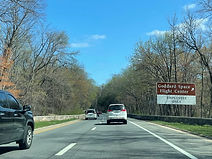
This offramp contains access to the National Cryptologic Museum. Photo taken 04-01-2025.

Westbound MD 32 leads to the Savage station of MARC's Camden Line via Dorsey Run Road. Photo taken 04-01-2025.

From here, MD 32 goes through Savage, then passes along the south side of Columbia, directly serving the villages of Owen Brown, Hickory Ridge and River Hill. Photo taken 04-01-2025.

After MD 32, the Parkway passes under Canine Road, one of the main roads in the Fort Meade/Annapolis Junction area. Photo taken 04-01-2025.

Canine Road has a partial two-ramp interchange with the Parkway, and its onramp to the northbound carriageway is at right. Photo taken 04-01-2025.

Jessup and (again) Fort Meade are served by the next interchange. Photo taken 04-01-2025.

The interchange intersects Maryland Route 175 (Jessup Road west/Annapolis Road east) toward the central part of Columbia and Odenton in half a mile. This is the final northbound interchange along the National Park segment of the Parkway. Photo taken 04-01-2025.

A southbound-facing sign marking the north end of the National Park segment is at left. Photo taken 04-01-2025.

The ramp to MD 175 is ahead, and the SHA will soon take control of the Parkway with MD 295 signage. Photo taken 04-01-2025.
