
The epzik8 Webpage
Baltimore-Washington Parkway south - I-95 to Maryland Route 175

The Baltimore-Washington Parkway (Maryland Route 295), going south, here passes over Interstate 895 (Harbor Tunnel Thruway) in the Lansdowne area of southwestern Baltimore County. Since I-895 is a toll road, there is only a southbound entrance and northbound exit ramp to it along MD 295. Photo taken 07-14-2025.

The Parkway soon crosses the non-tidal Patapsco River. Photo taken 07-14-2025.

On the other side of the Patapsco, the Parkway enters Anne Arundel County. Photo taken 07-14-2025.

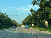
MD 295 is approaching an interchange with Interstate 695 (Baltimore Beltway). From here, interests to state capital Annapolis and the Chesapeake Bay Bridge can follow the outer loop of the Beltway (east) to southbound Interstate 97. Photo taken 07-14-2025.

The Beltway's inner loop (north), ¼ mile away, has a control city of Towson. Meanwhile, in the distance, Maryland Route 168 (Nursery Road) passes overhead. Photo taken 07-14-2025.

After the ramp to the inner loop, another offramp leads to the outer loop of I-695 and Glen Burnie. At this interchange, I-695's directional orientation shifts from north/south to east/west. Photo taken 07-14-2025.

The ramp to the outer loop is on the other side of these overpasses. Photo taken 07-14-2025.

The ramp to the outer loop is to the right. Photo taken 07-14-2025.

An interchange with West Nursery Road is half a mile away, while up ahead, Hammonds Ferry Road passes overhead. Photo taken 07-14-2025.
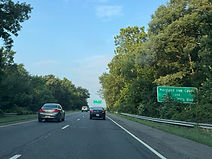
Before West Nursery, there is MD 295 reassurance. Photo taken 07-14-2025.

This is the exit of the West Nursery District of the BWI Region, which contains many of the retail and hotels on the north side of the airport area. Photo taken 07-14-2025.

An AM radio frequency for obtaining airport information is posted at right. Photo taken 07-14-2025.

The West Nursery exit is up ahead. The road goes northeast to Hammonds Ferry and south in the direction of the airport to Elkridge Landing. Photo taken 07-14-2025.

Within the West Nursery interchange, signage begins appearing for the Parkway's interchange with Interstate 195, which goes northwest toward Catonsville and the UMBC college campus, and southeast to BWI. Photo taken 07-14-2025.

The Parkway then makes its passage under West Nursery. Photo taken 07-14-2025.
A sign acknowledging UMBC for I-195 west is in the median. Photo taken 07-14-2025.

The BWI commuter rail station, which has Amtrak and MARC Penn Line service, can be reached from I-195 east. Photo taken 07-14-2025.

There is additional MD 295 reassurance prior to I-195. Photo taken 07-14-2025.

I-195 east is accessed from MD 295 south via a left exit, while the ramp to I-195 west is to the right. Photo taken 07-14-2025.

Ahead of the ramps to I-195, Winterson Road, where many of BWI's hotels are located, passes overhead. Photo taken 07-14-2025.

The I-195 east gore sign. Photo taken 07-14-2025.

The ramp from I-195 west to MD 295 south comes in at right. Photo taken 07-14-2025.

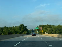
The Parkway goes on to pass under I-195. Photo taken 07-14-2025.

It then crosses Amtrak's Northeast Corridor, where the BWI rail station is situated. Photo taken 07-14-2025.

Finally, MD 295 south receives an onramp from I-195 east. Photo taken 07-14-2025.

At the Ridge Road overpass, Maryland Route 100 is 3 miles away, Maryland Route 175 6 miles ahead, and downtown Washington, DC is 31 miles away. Photo taken 07-14-2025.

The Parkway soon crosses Hanover Road. Photo taken 07-14-2025.

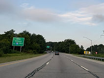
One-mile advance signage is then posted for the interchange with MD 100, which has control cities of Ellicott City and Glen Burnie. Photo taken 07-14-2025.

The Stoney Run District of the BWI Region is accessible from MD 100 east. Photo taken 07-14-2025.
Meanwhile, the Maryland Live Casino can be reached from the next exit at Arundel Mills. Photo taken 07-14-2025.

The exit to MD 100 west is ¼ mile before MD 100 east. Photo taken 07-14-2025.

The MD 100 west gore sign. Photo taken 07-14-2025.
Between ramps, MD 295 crosses over MD 100. Photo taken 07-14-2025.

The ramp to MD 100 east is at right. Photo taken 07-14-2025.

Afterward, there is further MD 295 reassurance. Photo taken 07-14-2025.
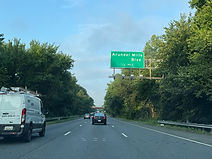
Arundel Mills Boulevard is intersected at an interchange half a mile away. Photo taken 07-14-2025.

The Parkway passes under Wright Road in the meantime. Photo taken 07-14-2025.

The Arundel Mills exit is just ahead. Photo taken 07-14-2025.

This exit opened in 2000 concurrent with the opening of the Arundel Mills Mall. Photo taken 07-14-2025.

The interchange with Maryland Route 175, with control cities of Odenton and Columbia, is a mile away. All large trucks must exit here because they are not permitted on the Parkway beyond this point. Photo taken 07-14-2025.

The right lane of the highway is marked for the ramp to MD 175 west. Photo taken 07-14-2025.

Jessup and a park and ride can be reached from MD 175 west, and Fort Meade from MD 175 east. Photo taken 07-14-2025.

MD 175 west also leads to the Waterloo "A" barrack of the Maryland State Police. Photo taken 07-14-2025.

Once again, the offramps to each direction of MD 175 are ¼ mile apart from one another. Photo taken 07-14-2025.

MD 175 east is the last chance for truckers to exit. Meanwhile, this interchange was undergoing reconstruction at the time of these photos. Photo taken 07-14-2025.

At this point, the State Highway Administration hands over control of the Parkway to the National Park Service, and MD 295 signage disappears. Photo taken 07-14-2025.
