
The epzik8 Webpage
Baltimore-Washington Parkway south - Maryland Route 175 to US 50

The Baltimore-Washington Parkway goes south after intersecting Maryland Route 175 at an interchange, at which point the National Park Service takes over maintenance from the State Highway Administration. Photo taken 07-14-2025.

A welcome sign from the Park Service sits in the median just over a mile before an interchange with Maryland Route 32 (Patuxent Freeway), which goes toward Columbia and Fort Meade. Photo taken 07-14-2025.

Brown Park Service mile markers were placed along this segment of the Parkway as part of improvements in the early 2020s. Photo taken 07-14-2025.

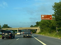
Before MD 32, the National Security Agency (NSA) has an exit to it. Photo taken 07-14-2025.

The Savage MARC commuter rail station can be reached from MD 32 west. Photo taken 07-14-2025.

The ramp to MD 32 west is to the right at mile marker 17. Photo taken 07-14-2025.
The Parkway passes under MD 32 before reaching the ramp to MD 32 east. Photo taken 07-14-2025.

The southbound carriageway subsequently receives traffic from MD 32 east on the right. Photo taken 07-14-2025.

After MD 32, the Parkway crosses the Little Patuxent River. Photo taken 07-14-2025.

In half a mile, the Parkway will reach an interchange with Maryland Route 198 which runs between Fort Meade and Laurel. Photo taken 07-14-2025.

The offramp to MD 198 is ahead on the right. Photo taken 07-14-2025.

The MD 198 exit gore sign. Photo taken 07-14-2025.

The Parkway then passes under MD 198. Photo taken 07-14-2025.

The highway continues south through a cluster of trees. Photo taken 07-14-2025.

The median clears out, and the Parkway is a mile from intersecting Maryland Route 197, which has control cities of Bowie and Laurel. Photo taken 07-14-2025.

The Montpelier Mansion and Arts Center in South Laurel is off this exit. Photo taken 07-14-2025.

Before MD 197, the Parkway crosses the Patuxent River, in doing so leaving Anne Arundel County and entering Prince George's County. Photo taken 07-14-2025.

The ramp to MD 197 is ahead on the right. Photo taken 07-14-2025.

The MD 197 exit gore sign. Photo taken 07-14-2025.

The Parkway has a pair of bridges over each direction of MD 197, which divides at this interchange. Photo taken 07-14-2025.

The onramp from MD 197 south to the southbound Parkway then comes in on the right. Photo taken 07-14-2025.

In half a mile, there is an exit at Powder Mill Road that serves Beltsville. Photo taken 07-14-2025.

The National Wildlife Visitor Center is off this exit. Photo taken 07-14-2025.

The Parkway then reaches the Powder Mill exit. Photo taken 07-14-2025.

The bridge over Powder Mill is completely paved over with asphalt. Photo taken 07-14-2025.

The Parkway soon reaches mile marker 9. Photo taken 07-14-2025.

More trees surround the highway between exits. Photo taken 07-14-2025.

At mile marker 8, there is an employee exit for NASA's Goddard Space Flight Center. Photo taken 07-14-2025.

An onramp from Goddard comes in at right. Photo taken 07-14-2025.

The next exit intersects Maryland Route 193 (Greenbelt Road), serves Greenbelt and the south side of Goddard, and is half a mile away. Photo taken 07-14-2025.

In one mile, after MD 193, the Parkway has an interchange with Interstate 95/495 (Capital Beltway) with control cities of Baltimore and Richmond, Virginia, both reflecting I-95's position along this side of the Beltway. Photo taken 07-14-2025.

The outer loop of the Beltway (north) has an additional control city of Silver Spring at the half-mile advance sign. Photo taken 07-14-2025.

The MD 193 exit, which also leads to the headquarters of the U.S. Park Police, is straight ahead. Photo taken 07-14-2025.

Traffic coming from MD 193 enters the southbound Parkway at right via Greenbelt's Southway. Photo taken 07-14-2025.

The ramp to the outer loop of the Beltway is just ahead. Photo taken 07-14-2025.

The inner loop of the Beltway has added signage for Joint Base Andrews at the interchange. Photo taken 07-14-2025.

The Parkway makes its passage over I-95/495 here. Photo taken 07-14-2025.

The southbound carriageway receives traffic from the inner loop of the Beltway to the right. Photo taken 07-14-2025.

The Parkway soon passes under Good Luck Road. Photo taken 07-14-2025.

Half a mile away, there is an interchange with Maryland Route 410 (East-West Highway) with control cities of New Carrollton and Hyattsville. Photo taken 07-14-2025.

The MD 410 exit is just ahead after a curve to the left. Photo taken 07-14-2025.

The Parkway uses this bridge to pass over MD 410. Photo taken 07-14-2025.

The highway curves wide right as it receives traffic from MD 410. Photo taken 07-14-2025.

Up ahead, the speed limit reduces to 45 miles per hour. Photo taken 07-14-2025.

The penultimate southbound exit is at Maryland Route 450 (Annapolis Road), which bears control cities of Annapolis (via Bowie) and Bladensburg. Photo taken 07-14-2025.

The Parkway goes on to pass under MD 450. Photo taken 07-14-2025.

The Parkway's final southbound exit is at Maryland Route 202 (Landover Road), seen here. Photo taken 07-14-2025.

There is another wide curve to the right at the Parkway's overpass over MD 202. Photo taken 07-14-2025.

A split in the roadway will occur at a forthcoming interchange with U.S. Route 50, where a left movement will lead toward Interstate 295 and US 50 east toward Richmond and Annapolis respectively, while going right puts one onto US 50 west, which promptly enters Washington, DC as New York Avenue. Photo taken 07-14-2025.

In the meantime, the Parkway passes over a segment of Maryland Route 201 (Kenilworth Avenue). Photo taken 07-14-2025.

The next overhead sign assembly removes the split diagram as well as the New York Avenue notation for US 50 west. Photo taken 07-14-2025.

The ramp to US 50 east trails the westbound ramp by ¼ mile. Photo taken 07-14-2025.

The southbound carriageway then passes over a ramp from US 50 east to the northbound Parkway. Photo taken 07-14-2025.

Finally, the Parkway ends as southbound MD 201 enters on the left, and the MD 201 designation continues for a few tenths of a mile to the District of Columbia line, where it becomes D.C. Route 295. Photo taken 07-14-2025.
