
The epzik8 Webpage
Baltimore-Washington Parkway north - MD 175 to I-95

A sign in the median of the Baltimore-Washington Parkway in the Jessup area of Anne Arundel County marks the highway's transition in maintaining authority from the National Park Service to the Maryland State Highway Administration. Just ahead, an exit ramp leads from the northbound lanes of the Parkway to Maryland Route 175. Photo taken 04-01-2025.

The MD 175 ramp sign and gore. Photo taken 04-01-2025.

This portion of the Parkway is a Maryland designated scenic byway. The Star-Spangled Banner byway between Washington and Baltimore also uses much of the Parkway. The Parkway also now receives the signed designation of Maryland Route 295, which exists unsigned along the NPS segment; it implies a continuation of Interstate 295 in the District of Columbia. Photo taken 04-01-2025.

The northbound carriageway receives a cloverleaf onramp from eastbound MD 175 before passing under the route. Photo taken 04-01-2025.

The Maryland Live Casino can be reached from the forthcoming exit. Photo taken 04-01-2025.
As this exit serves the Arundel Mills Mall, there is an array of food options. Photo taken 04-01-2025.

The first northbound MD 295 shield sits beside the half-mile notice for Arundel Mills Boulevard. Photo taken 04-01-2025.

The Parkway is three lanes wide at the Arundel Mills exit, which opened in 2000 alongside Arundel Mills itself. Photo taken 04-01-2025.

The northbound offramp has an uphill climb to Arundel Mills Boulevard. Photo taken 04-01-2025.

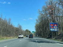
In one mile, MD 295 will have an interchange with Maryland Route 100, which has control cities of Glen Burnie to the east and Ellicott City to the west. Photo taken 04-01-2025.

The right lane will end in half a mile as it will become the ramp to MD 100 east. Photo taken 04-01-2025.

MD 100 east leads to the Stoney Run District of the BWI Region via Maryland Route 170. Photo taken 04-01-2025.

Wright Road passes over the Parkway before the exit. Photo taken 04-01-2025.

¼ mile past the eastbound MD 100 exit comes the exit to MD 100 west. MD 100 east goes on to pass south of BWI and Glen Burnie, with interchanges at Interstate 97 and Maryland Route 10, before ending at Maryland Route 177 in Jacobsville west of Gibson Island. Photo taken 04-01-2025.

There is an onramp from MD 100 east to MD 295 north, followed by a crossing by the latter over the former. Photo taken 04-01-2025.

MD 100 west proceeds from here to an interchange with I-95 south of Elkridge in Howard County, then winds its way east of Columbia to its north end at U.S. Route 29 in Ellicott City's far south. Photo taken 04-01-2025.

The Parkway's speed limit past MD 100 is 55 miles per hour. Photo taken 04-01-2025.

MD 295 reassurance is then given. Photo taken 04-01-2025.

To reach the campus of the University of Maryland Baltimore County (UMBC) in Arbutus, one can exit at I-195 west straight ahead. Photo taken 04-01-2025.

At Hanover Road, an overhead variable message sign announces the prohibition of hazmat vehicles in either of Baltimore's tunnels under the Patapsco River; this is in light of the 2024 Key Bridge collapse which affected travel arrangements for hazmat drivers. Photo taken 04-01-2025.

Interstate 195, a spur of I-95 between the BWI Airport and Catonsville, has an interchange with the Parkway in one mile. Photo taken 04-01-2025.

The BWI rail station along Amtrak's Northeast Corridor, served by Amtrak and MARC Penn Line trains, can be reached by taking I-195 east to MD 170 south to Stoney Run. Photo taken 04-01-2025.

Just past the Ridge Road overpass sits the ramp from MD 295 north to I-195 east, which leads straight into the BWI terminal. Photo taken 04-01-2025.

The ramp to I-195 west follows half a mile later. Photo taken 04-01-2025.

The eastbound I-195 gore sign. Photo taken 04-01-2025.

The Parkway passes over the Northeast Corridor within the I-195 interchange. Photo taken 04-01-2025.

I-195 passes overhead following the onramp to the northbound Parkway from I-195 east. Photo taken 04-01-2025.

The ramp to I-195 west to I-95 is ahead. Photo taken 04-01-2025.

Subsequently, the ramp from MD 295 south to I-195 east flies overhead. Photo taken 04-01-2025.

The Parkway now approaches its interchange with West Nursery Road which is half a mile away. There is also 1½ miles' notice for the Interstate 695 interchange. Photo taken 07-15-2024.

The speed limit is still 55 miles per hour. Photo taken 07-15-2024.

At right, there is a MD 295 reassurance shield along with a Chesapeake Bay Watershed marker. Photo taken 07-15-2024.

The upcoming exit serves the West Nursery District of the BWI region, where virtually all of the airport's adjacent hotels are located. Photo taken 07-15-2024.

This overhead sign points the way to the West Nursery exit. Photo taken 07-15-2024.

The West Nursery exit gore. Photo taken 07-15-2024.

The Parkway's interchange with I-695 (Baltimore Beltway) toward Glen Burnie and Towson is a mile away. Photo taken 07-15-2024.

An onramp from West Nursery comes in ahead at right. Photo taken 07-15-2024.

Vehicle restrictions for the Baltimore Harbor Tunnel along Interstate 895, intersected by the Parkway at a partial interchange ahead, are posted at right. Such vehicles were able to cross the Patapsco River by way of the Francis Scott Key Bridge on I-695 prior to its collapse in 2024; since then, their only legal option aside from Baltimore city streets is a clockwise trip along approximately three-quarters of the Beltway through most of Baltimore County's inner-ring suburbs. Photo taken 07-15-2024.
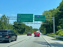
The distances to each of Baltimore's tunnels - the Harbor Tunnel and I-95's Fort McHenry Tunnel - are listed to the left on this gantry. To the right, the ramp from the northbound Parkway to the outer loop of I-695 (east) toward Glen Burnie is announced as being half a mile away. Photo taken 07-15-2024.

A second tunnel restrictions sign at right adds an I-95 shield to represent the Fort McHenry. Photo taken 07-15-2024.

The ramp to the outer loop of I-695 is on the other side of this overpass, which carries Hammonds Ferry Road over the Parkway. Photo taken 07-15-2024.

The cloverleaf ramp to the inner loop of I-695 toward Towson, the unincorporated seat of Baltimore County, is situated a mile prior to I-895. Photo taken 07-15-2024.

The exit gore sign for the Beltway inner loop. Photo taken 07-15-2024.

The Parkway gradually curves left as it receives inner loop traffic. Photo taken 07-15-2024.

MD 295 reassurance follows the Beltway. Photo taken 07-15-2024.

The highway then passes under Nursery Road again, this time billing it as Maryland Route 168. Photo taken 07-15-2024.

A final notice of Harbor Tunnel restrictions is posted by this overhead sign. Photo taken 07-15-2024.

Just before I-895, the Parkway crosses the non-tidal Patapsco River into Baltimore County. Photo taken 07-15-2024.

The ramp from northbound MD 295 to northbound I-895 is ahead at right. This is a two-ramp interchange; the other ramp is a cloverleaf going from I-895 south to MD 295 south. I-895's status as a tolled facility is the reason for the other two possible movements between the two highway being missing. Photo taken 07-15-2024.

The Parkway then proceeds over I-895. Photo taken 07-15-2024.

Beyond I-895, a wooden sign in the median states "Welcome to Baltimore", though the city line is actually nearly a mile to the north, and the actual location at the moment is Lansdowne. Photo taken 07-15-2024.

A disused pedestrian walkway then passes overhead. Photo taken 07-15-2024.

Having gone uphill slightly, the Parkway is once again over flat land. Photo taken 07-15-2024.

Next, the highway passes over Daisy Avenue, one of Lansdowne's main thoroughfares. Photo taken 07-15-2024.

The Horseshoe Casino on Russell Street is two miles ahead. Photo taken 07-15-2024.

MD 295 now enters Baltimore for real. Photo taken 07-15-2024.

The highway has an exit at Waterview Avenue in ¾ mile, then one at Wenburn Avenue, serving the Westport neighborhood, ¼ mile afterward. The next several sets of signs replaced, in 2021, ones that had been up for decades and slowly decaying. Photo taken 07-15-2024.

This next overpass carries Patapsco Avenue, which passes through Cherry Hill nearby. Photo taken 07-15-2024.

Annapolis Road (Maryland Route 648) crosses here. Photo taken 07-15-2024.

There is then a CSX rail bridge before the highway curves left. Photo taken 07-15-2024.

The sign at right points the way to Waterview Avenue. In ¾ mile, there is a ramp to Monroe Street, which is touted by this sign as northbound U.S. Route 1. However, US 1 does not join Monroe until a few tenths of a mile to the north; additionally, US 1's portion of Monroe actually forms the southbound (not northbound) component of a one-way pair with Fulton Avenue. Photo taken 07-15-2024.

The Waterview ramp gore sign. Photo taken 07-15-2024.

MD 295's ramp to northbound I-95, with control city New York (via Wilmington, Philadelphia and north Jersey), is half a mile away. Photo taken 07-15-2024.

Before any further exit ramps, a pedestrian overpass linking two disconnected sections of Westport's Maisel Street passes over the highway. A few blocks to the west sits the Westport station of the Baltimore Light RailLink. Photo taken 07-15-2024.

The left two through lanes are now marked as going into downtown Baltimore via Russell Street. The right through lane is marked for Monroe Street, and to the right of that is the Wenburn Street exit. Photo taken 07-15-2024.

The Wenburn ramp gore sign. Southbound access to Westport is via Manokin Street. Photo taken 07-15-2024.

The speed limit has now dropped to 45 miles per hour. Photo taken 07-15-2024.

The ramp to I-95 north is just after a righthand curve. Photo taken 07-15-2024.

Past I-95, Russell Street passes by Baltimore's two major league sports venues, M&T Bank Stadium (Ravens) and Oriole Park at Camden Yards, with access to Martin Luther King Boulevard in between, then comes across the University of Maryland Medical Center. Photo taken 07-15-2024.