
The epzik8 Webpage
U.S. Route 41 south - Naples to Ochopee

U.S. Route 41 (Tamiami Trail) is seen pulling away from Collier County Route 951 on the east side of Naples, near Marco Island. Photo taken 10-03-2024.

Carnestown and Miami are a respective 26 and 94 miles away. Although signed north-south, this segment of US 41 runs east-west. Photo taken 10-03-2024.

The speed limit is currently 50 miles per hour. Photo taken 10-03-2024.

The route's two carriageways soon consolidate into one. Photo taken 10-03-2024.

Now a two-way trafficway, US 41 intersects Lake Park Boulevard beside the Boyne South subdivision. Photo taken 10-03-2024.
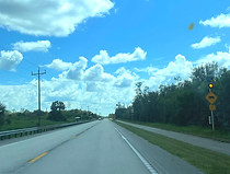
The first of many panther crossing signs from here to the east end of the Everglades is seen at right. Photo taken 10-03-2024.

The speed limit is now 60 with a night limit of 45. The night speed limit sign is black for strategic visibility in darkness. Photo taken 10-03-2024.

The route proceeds to enter Collier-Seminole State Park. Photo taken 10-03-2024.

A junction with CR 92 (San Marco Road) nears. Photo taken 10-03-2024.

CR 92 leads to Marco Island and Goodland. This intersection bears yellow flashers at US 41, and red flashers at CR 92. Photo taken 10-03-2024.

West Miami and Miami are now 74 and 86 miles away. Photo taken 10-03-2024.

The speed limit remains 60. Photo taken 10-03-2024.

US 41 then passes over several streams in quick succession. Photo taken 10-03-2024.

The route continues east amid a mix of palm and deciduous trees. Photo taken 10-03-2024.

A crossing of the Faka Union Canal is in half a mile. Photo taken 10-03-2024.

After the canal, the highway intersects Union Road (left) and Cays Drive (right). Photo taken 10-03-2024.

The route is now passing through an Indian village. Photo taken 10-03-2024.

The Big Cypress Bend Boardwalk is a left turn away. Photo taken 10-03-2024.

The route curves wide left up ahead. Photo taken 10-03-2024.

Several more small bridges over water are forthcoming. Photo taken 10-03-2024.

Near one of those bridges, there is a pond on the left side of the highway. Photo taken 10-03-2024.

The route is now preparing to curve right. Photo taken 10-03-2024.

Subsequently, the Shark Valley visitor center of Everglades National Park is announced as being 41 miles away. Photo taken 10-03-2024.

A sign with a flasher warns of an approaching traffic signal. Photo taken 10-03-2024.

The Fakahatchee Strand Preserve State Park is three miles' drive to the left, i.e. north. Photo taken 10-03-2024.

The signal is located at the meeting of State Road and County Route 29. Photo taken 10-03-2024.

SR 29 leads north to Immokalee; CR 29 south to Everglades City and Chokolosee, the latter Southwest Florida's southernmost point, if mainland Monroe County is not included. Photo taken 10-03-2024.

An airport and Florida Heritage Museum are located in Everglades City. Photo taken 10-03-2024.

From here, SR 29 leads 17 miles north to I-75. Photo taken 10-03-2024.

The signal is followed by US 41 reassurance. Photo taken 10-03-2024.

The highway now enters the Big Cypress National Preserve. Photo taken 10-03-2024.

The speed limit is still 60, but the night limit has disappeared. Photo taken 10-03-2024.