
The epzik8 Webpage
U.S. Route 40 west - Baltimore

After crossing Herring Run and receiving a long onramp from Moravia Road, U.S. Route 40 (Pulaski Highway) pushes west into the city of Baltimore. Seen here is a traffic signal at the entrance to the highway maintenance division of the Baltimore City Department of Transportation. Photo taken 07-28-2024.

In ⅓ mile (a rare distance on highway signs in Maryland), US 40 will reach Erdman Avenue (Maryland Route 151, also forming part of a truck route for US 40 passing north of truck-restricted downtown Baltimore). Photo taken 07-28-2024.

Here, US 40 passes over I-895 (Harbor Tunnel Thruway). Just off-picture, there is an exit ramp from I-895 north to US 40 east. Because I-895 is mostly a toll road, there is no access from US 40 west to I-895 north. Photo taken 07-28-2024.

A traffic light then sits at Armstead Way. Photo taken 07-28-2024.

Two through lanes are set aside for westbound US 40, one for the ramp to eastbound Erdman, and up ahead sits the ramp to westbound Erdman. This marks the east end of US 40 Truck, which uses Erdman to Belair Road, North Avenue (both U.S. Route 1) and Hilton Parkway to avoid downtown. That ramp also provides access to I-895 south toward the Harbor Tunnel. Photo taken 07-28-2024.

MD 151 passes over US 40 ahead. Signage for both it and I-895 south are obscured by trees. Photo taken 07-28-2024.

The cloverleaf ramp to MD 151 west is at right. Photo taken 07-28-2024.

A subsequent CSX crossing has Baltimore's name painted on it. Photo taken 07-28-2024.

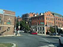
Bearing right soon afterward is Monument Street, which runs west along the north side of Johns Hopkins to the namesake Washington Monument, then ends up at McCulloh Street near Seton Hill, some blocks west of Mount Vernon. Photo taken 07-28-2024.

Then, Amtrak's Northeast Corridor, which here also carries MARC's Penn Line, passes overhead. Photo taken 07-28-2024.

Soon, the route intersects Haven Street, one of the main streets of Highlandtown. Photo taken 07-28-2024.

Slightly further ahead, there is a signal at Conkling Street. Photo taken 07-28-2024.

The next light is at Highland Avenue. Photo taken 07-28-2024.

That signal is followed by US 40 reassurance. Photo taken 07-28-2024.

It is just beyond this light, at Ellwood Avenue, that US 40 transitions from Pulaski Highway to Orleans Street. Pulaski Highway continues for a few additional blocks to the southwest as a city street. Photo taken 07-28-2024.

The route has a righthand S-curve and prepares to intersect Curley Street. Photo taken 07-28-2024.

Up ahead is Linwood Avenue, which runs along the east edge of Patterson Park and also accesses the Frank Bocek Park to the north. In the distance, the Johns Hopkins hospital is starting to become visible. Photo taken 07-28-2024.

The one-way southbound Lakewood Avenue leads to the St. Elizabeth School. Photo taken 07-28-2024.

Next intersected is Milton Avenue, heading north to McElderry Park. Photo taken 07-28-2024.

Up ahead, Patterson Park Avenue, besides leading to the titular park, access the Great Blacks in Wax museum as well as the diagonal Gay Street. Photo taken 07-28-2024.

The southern two blocks of the next-intersected street, Chester Street, form the boundary between Canton and Fells Point. Photo taken 07-28-2024.

Pushing toward Hopkins, US 40 intersects Washington Street, which goes north to Clifton Park, then continues northwest from there as the Alameda. Photo taken 07-28-2024.

On the east side of Hopkins, the route meets Wolfe Street. Photo taken 07-28-2024.

A footbridge bearing the Johns Hopkins wordmark passes overhead. Photo taken 07-28-2024.

There is a second footbridge between the Kennedy Krieger Institute and the Weinberg Building. Photo taken 07-28-2024.

At the west end of Hopkins, US 40 meets Broadway. Photo taken 07-28-2024.

As it passes by Douglass Homes and Dunbar High School, the route intersects Caroline Street. Photo taken 07-28-2024.

The next signal is at Central Avenue near the Enoch Pratt Free Library. Photo taken 07-28-2024.

US 40 then comes across Aisquith Street. Photo taken 07-28-2024.

It then meets Forrest Street beside the former Old Town Mall. Photo taken 07-28-2024.

The next signal sees US 40 intersect both Ensor Street and Exeter Street. Photo taken 07-28-2024.

On that note, the Orleans Street Bridge commences. Photo taken 07-28-2024.

There is a pair of sharp turns ahead at the end of the bridge. Photo taken 07-28-2024.

At this point on the bridge, US 40 passes over Interstate 83 (Jones Falls Expressway) beside the Mercy Medical Center. Photo taken 07-28-2024.

The end of the bridge, and US 40's entry into downtown Baltimore, is imminent. Photo taken 07-28-2024.

Westbound US 40 now curves right as the route splits into Franklin Street westbound and Mulberry Street eastbound. Photo taken 07-28-2024.
Franklin Street proceeds to intersect St. Paul Street, the southbound component of Maryland Route 2 in this area. Photo taken 07-28-2024.

The speed limit is now 30 miles per hour. Photo taken 07-28-2024.

The next signal is at Cathedral Street, which becomes Liberty Street a few blocks to the south. Photo taken 07-28-2024.