
The epzik8 Webpage
U.S. Route 29 south

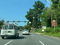
U.S. Route 29 begins at Maryland Route 99 (Rogers Avenue) near Ellicott City in Howard County and proceeds south. Photo taken 06-21-2025.

A traffic signal sits ahead at the end of an offramp from eastbound Interstate 70. Photo taken 06-21-2025.

Southbound US 29 has control cities of Columbia and Washington, DC, while I-70 leads west to Frederick and east to Baltimore. Photo taken 06-21-2025.

Exit 25B facilitates movements from US 29 south to I-70 west. Photo taken 06-21-2025.

The route then passes over I-70. Photo taken 06-21-2025.

Exit 25A is a cloverleaf leading from US 29 south to I-70 east. Photo taken 06-21-2025.

Ahead, US 29 south receives traffic from I-70 east. Photo taken 06-21-2025.

A sweeping lefthand ramp from I-70 west then reaches US 29 south. Photo taken 06-21-2025.

Up ahead, exit 24A can be used to access Ellicott City's historic district. Photo taken 06-21-2025.

After US 29's two carriageways come together, there is half-mile southbound advance signage for exit 24, which intersects U.S. Route 40 (Baltimore National Pike). A sign to the left of that warns of congestion for the next three miles. Photo taken 06-21-2025.

Services are available in each direction of US 40. Photo taken 06-21-2025.

Westbound US 40 does not have a control city at exit 24; it leads a few miles west to I-70, with which it overlaps for about 29 miles to Frederick. Photo taken 06-21-2025.

US 29 then reaches exit 24A for US 40 east. Photo taken 06-21-2025.

The next three exits fall within a span of 2½ miles. Photo taken 06-21-2025.

One mile away, exit 22, a left exit, leads to eastbound Maryland Route 100 and the Glen Burnie area of Anne Arundel County. Photo taken 06-21-2025.

The highway crosses Frederick Road between exits. Photo taken 06-21-2025.

¼ mile before MD 100, US 29 intersects Maryland Route 103 (St. John's Lane) at exit 23. Photo taken 06-21-2025.

There is a park and ride that can be reached from exit 22 by taking MD 100 to exit 1A (Long Gate Parkway). Photo taken 06-21-2025.

This overhead sign points the way to exit 23. Photo taken 06-21-2025.

Exit 22 is ahead to the left. MD 100 did not reach US 29 until 1998. Photo taken 06-21-2025.

The exit 22 gore sign. Photo taken 06-21-2025.

Exit 21 intersects Maryland Route 108 (Clarksville Pike), which has a westbound control city of Clarksville. Photo taken 06-21-2025.
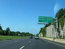
The north Columbia villages of Dorsey's Search and Harper's Choice can be reached from exit 21B (MD 108 west). Photo taken 06-21-2025.

Exit 21B hosts an array of driver services. Photo taken 06-21-2025.

Exits 21B and A are a quarter mile apart. Photo taken 06-21-2025.

After exit 21A, exit 20 will intersect the west end of Maryland Route 175, which leads to Jessup; the exit also serves the Columbia Town Center via Little Patuxent Parkway. Photo taken 06-21-2025.
The gore for exit 21A. Photo taken 06-21-2025.

The village of Wilde Lake is off exit 20B, and Oakland Mills and Long Reach can be reached from exit 20A. Photo taken 06-21-2025.

These two signs each reiterate the town center's position off exit 20B. Photo taken 06-21-2025.

Exit 20B is half a mile prior to exit 20A. Photo taken 06-21-2025.

Exit 20A to MD 175 east is on the other side of this overpass. Photo taken 06-21-2025.

US 29's next junction is a right-in/right-out with South Entrance Road, which leads to the famed Merriweather Post Pavilion. Photo taken 06-21-2025.

At the next exchange, exit 18 intersects Broken Land Parkway which runs between the town center and Oakland Mills. Photo taken 06-21-2025.

The Lake Kittamaqundi Trail passes overhead here. Photo taken 06-21-2025.

The villages of Owen Brown and Hickory Ridge as well as the Howard Community College can all be accessed from exit 18. Photo taken 06-21-2025.

Driver services are again available at exit 18. Photo taken 06-21-2025.

A VEIP emissions inspection station is off this exit. Photo taken 06-21-2025.

The highway now crosses the Little Patuxent River. Photo taken 06-21-2025.

Exit 18 lies just ahead, with the next two exits following within a mile and a half. Photo taken 06-21-2025.

Exit 17 intersects Seneca Drive and Shaker Drive, and exit 16 intersects Maryland Route 32 (Patuxent Freeway) which has control cities of Clarksville and Fort Meade. Photo taken 06-21-2025.

Exit 16A can be taken to the Village of Kings Contrivance. Photo taken 06-21-2025.

Exit 16B lies straight ahead. Photo taken 06-21-2025.

The exit 16B gore sign. Photo taken 06-21-2025.

Exit 16A follows shortly thereafter. Photo taken 06-21-2025.

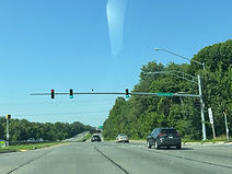
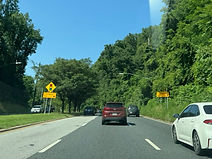
After MD 32, drivers will have to slow down for an approaching traffic signal. Photo taken 06-21-2025.

Said signal is equipped with warning flashers. Photo taken 06-21-2025.

This signal is at Rivers Edge Road, which leads into the Riverside development of Kings Contrivance, in an area historically known as Simpsonville. Photo taken 06-21-2025.

Rivers Edge is a "seagull intersection", one of many in Maryland, which is set up so that northbound traffic never has to stop because they face no oncoming traffic. Photo taken 06-21-2025.

After that, the expressway resumes as it approaches exit 15, intersecting Johns Hopkins Road leading to Gorman Road. Photo taken 06-21-2025.

Before exit 15, US 29 crosses the Middle Patuxent River. Photo taken 06-21-2025.

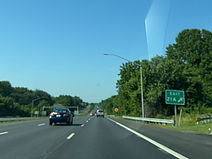
Exit 15 is located straight ahead, at the crest of a hill. Photo taken 06-21-2025.

US 29 then approaches exit 13 with Maryland Route 216, with control cities of Fulton and Laurel. Photo taken 06-21-2025.

The first US 29 reassurance shield in a while sits between exits. Photo taken 06-21-2025.

Exit 13 lies just ahead. Photo taken 06-21-2025.

The exit 13 gore sign. Exits 15 and 13 both were not built until the early 2000s. Photo taken 06-21-2025.

A crossroads with Old Columbia Road is approaching. Photo taken 06-21-2025.

The southbound lanes have a hard-right turn onto Old Columbia Road. Photo taken 06-21-2025.

In one mile, US 29 will meet Maryland Route 198 at an interchange. Photo taken 06-21-2025.

Meanwhile, US 29's interchange with Interstate 495 (Capital Beltway) is 14 minutes away. Photo taken 06-21-2025.

The highway now has a curvaceous descent into the Patuxent valley. Photo taken 06-21-2025.

The MD 198 exit, now half a mile away, leads to the Burtonsville Town Center. Photo taken 06-21-2025.

Before MD 198, US 29 crosses the Patuxent River, the longest entirely within Maryland. Photo taken 06-21-2025.

US 29 is now in Montgomery County and the greater Washington, DC area. Photo taken 06-21-2025.

This exit can be used to reach Old Columbia Pike and Blackburn Road. Photo taken 06-21-2025.

The offramp to MD 198 is straight ahead. Photo taken 06-21-2025.

At a hillcrest, Dustin Road passes overhead. Photo taken 06-21-2025.

A park and ride with Metrobus access is ahead to the right. Photo taken 06-21-2025.

The offramp component of the right-in/right-out leading to the park and ride, as well as National Drive beside the town center, is at right. Photo taken 06-21-2025.

US 29 goes on to cross MD 198 via this overpass. Photo taken 06-21-2025.

Traffic will once again be slowed by a traffic signal up ahead. Photo taken 06-21-2025.

Northbound US 29 receives traffic from MD 198 up ahead. Photo taken 06-21-2025.

Intersected here, Blackburn Road services subdivisions on the east side of Burtonsville, such as the Country Place apartments. Photo taken 06-21-2025.

The highway goes downhill as it passes near the Fairland Regional Park. Photo taken 06-21-2025.

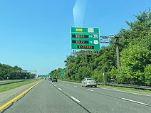
Travel and toll information for Maryland Route 200 a couple miles ahead can be heard on 1670 AM. Photo taken 06-21-2025.

The distances to Briggs Chaney Road and MD 200 are posted here, though obscured by tree branches. Photo taken 06-21-2025.
Greencastle Road is intersected in the meantime. Photo taken 06-21-2025.

Briggs Chaney Road is now half a mile away, MD 200 one mile, and Fairland Road 1½ miles. Photo taken 06-21-2025.
Toll rates for each direction of MD 200 are posted by this sign. Photo taken 06-21-2025.

The ramp to Briggs Chaney is ahead on the right. Photo taken 06-21-2025.

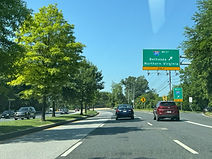
Up ahead, an offramp leads from US 29 south to MD 200 west, which goes to Interstate 270 via Interstate 370 in Gaithersburg. Photo taken 06-21-2025.

A sign at right points toward the ramps to each direction of MD 200. Photo taken 06-21-2025.

Approaching the Fairland Road exit, the ramp to MD 200 west, which leads to Interstate 95 and U.S. Route 1 on the south side of Laurel in Prince George's County, leaves US 29 south. Photo taken 06-21-2025.

As the highway nears an at-grade intersection with Fairland, the distances to the next two signals and interchange, which fall within a one-mile span, are posted overhead. Photo taken 06-21-2025.

No turns are permitted from US 29 south onto Fairland because those movements were provided by the preceding exit ramp. Photo taken 06-21-2025.

Approaching Musgrove Road, the far right southbound lane is set aside for the Cherry Hill/Randolph exit. Photo taken 06-21-2025.

The Musgrove Road signal sits here. Photo taken 06-21-2025.
This sign then points the way to the offramp to Cherry Hill and Randolph. Photo taken 06-21-2025.

As a collective entity, Randolph and Cherry Hill roads go from Rockville Pike (MD 355) in the North Bethesda section of south Rockville, to US 1 just north of College Park in P.G. County. Photo taken 06-21-2025.

After that interchange, the highway's median narrows and it has a traffic signal at Industrial Parkway. Photo taken 06-21-2025.

In ¾ mile, US 29 will have an interchange with Maryland Route 650 (New Hampshire Avenue). Photo taken 06-21-2025.

Beforehand, the highway has a traffic signal at a crossover to Old Columbia Pike and another at Stewart Lane. Photo taken 06-21-2025.

Stewart Lane leads left into the Pine Hill subdivision of White Oak. Photo taken 06-21-2025.

US 29 reaches the offramp to MD 650 north beside the White Oak Shopping Center. Photo taken 06-21-2025.

At the interchange, MD 650 south has a control city of Langley Park. Photo taken 06-21-2025.

The gore sign for MD 650 south. Photo taken 06-21-2025.

This is followed by US 29 reassurance. Photo taken 06-21-2025.

The next traffic signal is at Oak Leaf Drive. Photo taken 06-21-2025.

After curving left, the route intersects Prelude Drive. Photo taken 06-21-2025.

Ahead, the speed limit drops to 40 miles per hour. Photo taken 06-21-2025.
The route then meets Lockwood Drive, which passes through the center of White Oak just to the north. Photo taken 06-21-2025.

There is another US 29 shield as the route glides downhill. Photo taken 06-21-2025.

There is then a traffic signal at the entrance to the Shoppes of Burnt Mills. Photo taken 06-21-2025.

Next, the highway crosses Northwest Branch which is a part of the Anacostia River watershed. Photo taken 06-21-2025.
Subsequently, there is a signal at Southwood Avenue. Photo taken 06-21-2025.

Within an S-curve, the route then intersects Lorain Avenue. Photo taken 06-21-2025.

US 29 will soon cross paths with Maryland Route 193 (University Boulevard). Photo taken 06-21-2025.

The next overhead sign is augmented by ground signage. Photo taken 06-21-2025.

MD 193 goes from here into P.G. County, through the College Park campus of the University of Maryland, then east through Greenbelt and Seabrook, before turning south and cutting through Mitchellville before ending at MD 202 a few miles north of Upper Marlboro. Photo taken 06-21-2025.

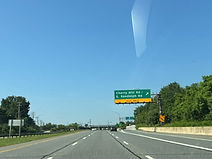
A quarter mile away, there is an exit ramp to the outer loop of the Capital Beltway (I-495), which serves interests from here to Bethesda and Northern Virginia. Photo taken 06-21-2025.

Before I-495, there is a traffic signal at Lanark Way. Photo taken 06-21-2025.
The ramp to the outer loop of I-495 is ahead at right. To reach the inner loop from US 29 south, one must follow MD 193 east. Photo taken 06-21-2025.

US 29 crosses the Beltway here. Photo taken 06-21-2025.

Hastings Drive (left) and Granville Drive (right) are intersected next. Photo taken 06-21-2025.

The Hastings/Granville light uses a slanted mast arm design that the State Highway Administration rolled out in the 2020s. Photo taken 06-21-2025.

There is next a crossroads at Leighton Avenue. Photo taken 06-21-2025.

Intersected here, Franklin Avenue goes into the Brookside Forest development. Photo taken 06-21-2025.

The route then meets Sligo Creek Parkway, which follows its namesake creek and leads to the Sligo Park Golf Course in Forest Glen. Photo taken 06-21-2025.
As US 29 heads into downtown Silver Spring, reversible lane markers start appearing, and there is a notation for interests to the Fillmore and AFI Silver Theatre to use the downtown parking garages. Photo taken 06-21-2025.

Which direction has the larger amount of travel lanes along this portion of US 29 is dependent on whether more workday traffic is entering or leaving Washington, DC. In the morning, all lane markers in this direction (inbound) would be green arrows. Photo taken 06-21-2025.

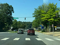
Next, there is a traffic signal at Dale Drive. Photo taken 06-21-2025.

Silver Spring's Veterans Plaza can be reached by making a left turn on Spring Street up ahead. Photo taken 06-21-2025.

The route's next intersection is at North Noyes Street. Photo taken 06-21-2025.

The brown sign at right points toward each of Silver Spring's downtown garages. Photo taken 06-21-2025.

US 29 now reaches Spring Street. Photo taken 06-21-2025.

The route goes on to approach a junction with Maryland routes 384 and 97. Photo taken 06-21-2025.

MD 97 (Georgia Avenue) has its southern terminus at this intersection. Photo taken 06-21-2025.

It is here that US 29 turns south onto Georgia Avenue. Photo taken 06-21-2025.

Another access point to the downtown garages is to the right after the turn. Photo taken 06-21-2025.

US 29 soon reaches Silver Spring Avenue, which goes due east to Sligo Hills Park. Photo taken 06-21-2025.
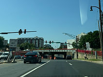
The route intersects Sligo Avenue before it passes under Washington Metro's Red Line and CSX's Metropolitan Subdivision, which facilitates Amtrak trains and MARC's Brunswick Line. Photo taken 06-21-2025.

US 29 now makes its passage under the train tracks. Photo taken 06-21-2025.

The route then intersects Maryland Route 410 at East-West Highway, opposite Burlington Avenue. Photo taken 06-21-2025.

US 29's final signal in Maryland is at 13th Street to the left. Photo taken 06-21-2025.

The route then reaches Eastern Avenue (right) and Blair Road (left) and enters northwest Washington, DC between the city's Shepherd Park and Takoma neighborhoods. Photo taken 06-21-2025.