
The epzik8 Webpage
U.S. Route 1 north - District of Columbia line to Baltimore

Known for now as Washington Boulevard, U.S. Route 1 leaves behind its interchange with Maryland Route 100 in the Elkridge area of Howard County and encounters Amberton Drive at this traffic signal. Photo taken 01-15-2025.

The highway eases downhill following that intersection. Photo taken 01-15-2025.

Another signal awaits at Troy Hill Drive. Photo taken 01-15-2025.

An industrial street, Troy Hill loops back around to US 1 south about a quarter-mile behind. Photo taken 01-15-2025.

As it crosses a tributary of Shallow Run (the name an antithesis to nearby Deep Run), US 1 nears Ducketts Lane. Photo taken 01-15-2025.

Spelled with an apostrophe at the signal, Ducketts Lane serves the area Glen Cove Estates development. Photo taken 01-15-2025.

Loudon Avenue is intersected soon thereafter. Photo taken 01-15-2025.

Hunt Club Road and South Hanover Road are then met at separate intersections. Photo taken 01-15-2025.

Truckers are advised to go no more than 40 MPH through here. Photo taken 01-15-2025.

Two more residential streets, Rowanberry Drive and Pine Avenue, are ahead. Photo taken 01-15-2025.

Old Washington Road, US 1's old alignment through Elkridge, now unsigned MD 977, bears off to the right ahead. Photo taken 01-15-2025.

Old Washington Road is at right. Photo taken 01-15-2025.

An Elkridge welcome sign is then seen to the right. Photo taken 01-15-2025.

There is then access from Old Washington Road to US 1 north. Photo taken 01-15-2025.

The speed limit is currently 40 miles per hour. Photo taken 01-15-2025.

There is a signal at Montgomery Road ahead. Photo taken 01-15-2025.

Montgomery Road exists in multiple segments from here to the eastern villages of Columbia, and has a crossing of Interstate 95 just to the west. Photo taken 01-15-2025.

Next comes a crossroads at Bonnie View Lane. Photo taken 01-15-2025.

Bonnie View provides a link between Old Washington and Lawyers Hill Road. Photo taken 01-15-2025.

US 1 intersects the three posted descendants of I-95 in the next three miles. Photo taken 01-15-2025.

The highway curves right and becomes forested as it enters the Patapsco Valley. Photo taken 01-15-2025.

The speed limit remains 40 through here. Photo taken 01-15-2025.

To the right, US 1 receives the north end of Old Washington. Photo taken 01-15-2025.

Access to Interstate 895 (Harbor Tunnel Thruway) is in ¼ mile. Photo taken 01-15-2025.

In the meantime, US 1 intersects Brumbaugh Street and passes under CSX's Capital Subdivision. Photo taken 01-15-2025.

On the other side of the rail bridge is Railroad Avenue. Photo taken 01-15-2025.

Next comes a traffic signal at Levering Avenue, which leads into Main Street and Furnace Avenue at right. Photo taken 01-15-2025.

The Harbor Tunnel entrance is at right. There are no exits prior to the toll plaza, and only one prior to the south entrance of the tunnel. Photo taken 01-15-2025.

I-895, before the designation was applied, had its west end here for some years until it was extended west to I-95 following its completion between the Baltimore and Capital Beltways. Photo taken 01-15-2025.

On that note, US 1 crosses the non-tidal Patapsco River into southwestern Baltimore County. Photo taken 01-15-2025.

I-895 passes overhead at this point, followed by the ramp from I-895 south to US 1 south. Photo taken 01-15-2025.

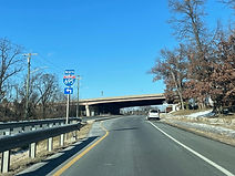
A cloverleaf ramp to eastbound Interstate 195 and the Baltimore/Washington International Airport (BWI) is ahead at left. Photo taken 01-15-2025.

The ramps between US 1 and I-195 east are signalized. Photo taken 01-15-2025.

Next comes the ramp to I-195 west toward I-95 and Catonsville. I-195 crosses over I-895 just to the southeast of here, but does not have an interchange. Photo taken 01-15-2025.

There is a traffic signal at this ramp as well. Photo taken 01-15-2025.

US 1 reassurance follows I-195. Photo taken 01-15-2025.

Next, there is a traffic light at the Guinness OpenGate Brewery entrance. Photo taken 01-15-2025.

The Halethorpe station of MARC's Penn Line can be reached by keeping right on mainline US 1 up ahead. Photo taken 01-15-2025.

Intersected ahead is Clarke Boulevard, leading to Selford Road. Photo taken 01-15-2025.

US 1 passes over MARC's Camden Line prior to splitting from its alternate. Photo taken 01-15-2025.

U.S. Route 1 Alternate can be reached from either northbound lane, while only the right lane is available for movements to remain on mainline US 1. Photo taken 01-15-2025.

US 1 Alt. continues northeast as Washington Boulevard, while mainline US 1 becomes Southwestern Boulevard. Photo taken 01-15-2025.

US 1 reassurance immediately follows the split. Photo taken 01-15-2025.

There are pedestrian crosswalks for the next half-mile. Photo taken 01-15-2025.

Southwestern Boulevard consolidates into a single roadway ahead. Photo taken 01-15-2025.

Subsequently, it crosses Herbert Run. Photo taken 01-15-2025.

US 1 reassurance sits beside the Northeast Corridor tracks. Photo taken 01-15-2025.

A crosswalk between MARC parking lots is ahead. Photo taken 01-15-2025.

The Halethorpe MARC station is at right. Photo taken 01-15-2025.

Francis Avenue passes overhead north of the station. Photo taken 01-15-2025.

Marked as leading into Halethorpe proper, Tom Day Boulevard is ahead on the left. Photo taken 01-15-2025.

This portion of US 1 is dedicated to the late John C. Coolahan, former Maryland state senator, candidate for Baltimore County executive and Halethorpe/Arbutus community man. Photo taken 01-15-2025.

Next, US 1 passes under eight lanes of I-95. Photo taken 01-15-2025.

The median then turns from a concrete barrier into a center left-turn lane. Photo taken 01-15-2025.

Arbutus can be reached by making a left at the next signal. Photo taken 01-15-2025.

The signal is at Linden Avenue which goes to Sulphur Spring Road. Photo taken 01-15-2025.

After Linden, US 1 approaches its exchange with the outer loop (north) of I-695. Photo taken 01-15-2025.

The control city for I-695 north is Towson, via Catonsville and Pikesville. Photo taken 01-15-2025.
The ramp to the outer loop is ahead at left. Photo taken 01-15-2025.

I-695 then passes overhead. US 1 has a full, eight-ramp cloverleaf interchange with the Beltway on the other side of Baltimore, in Overlea. Photo taken 01-15-2025.

Leeds Avenue is intersected just after I-695. Photo taken 01-15-2025.

The speed limit is still 40. Photo taken 01-15-2025.

Leeds Avenue provides additional Beltway access via Wilkens Avenue. Photo taken 01-15-2025.

A grassy median with trees now appears as US 1 enters the Oaklee section of southwest Baltimore. Photo taken 01-15-2025.

The roadway curves to the right up ahead. Photo taken 01-15-2025.

US 1 now reaches and assumes the name of Wilkens Avenue, which comes in from the west as Maryland Route 372. Photo taken 01-15-2025.

Entering Violetville, US 1 passes over the Northeast Corridor. Photo taken 01-15-2025.

It subsequently reaches Haverhill Road at a traffic signal. Photo taken 01-15-2025.

The next light is at Pine Heights Avenue. Photo taken 01-15-2025.

The route then takes time to pass by St. Agnes Hospital. Photo taken 01-15-2025.

At the next light at Caton Avenue, US 1 Alt. ends. Caton goes south to Patapsco Avenue and has its own interchange with I-95, and it goes north to Frederick Avenue and becomes Hilton Street, then limited-access Hilton Parkway. Photo taken 01-15-2025.

Following Caton Avenue is a curve, with Morrell Park to the right. Photo taken 01-15-2025.

DeSoto Road, seen here, goes southeast under I-95 and out to Washington Boulevard. Photo taken 01-15-2025.

Next appears a disused railroad bridge. Photo taken 01-15-2025.

The next light is at Hurley Avenue (left) and Dukeland Street (right). Photo taken 01-15-2025.

After crossing Gwynns Falls, the route reaches Brunswick Street, a connection to Frederick Avenue. Photo taken 01-15-2025.

A stone barrier has now appeared in the median. Photo taken 01-15-2025.

Three blocks to the northeast is Catherine Street, which runs to just shy of the Carroll Park Golf Course. Photo taken 01-15-2025.

A non-signalized intersection at Bentalou Street follows. Photo taken 01-15-2025.

Pulaski Street, no relation to Pulaski Highway, runs due north several blocks to Lafayette Street. Photo taken 01-15-2025.

Then, Wilkens Avenue reaches Monroe Street, the southbound component of a one-way pair utilized by US 1 through the innermost portion of west Baltimore. Monroe continues southeast of here to Annapolis Road near the interchange of I-95 and MD 295, and a cloverleaf ramp leads to northbound Monroe from northbound MD 295. Photo taken 01-15-2025.

Northbound US 1 then makes a left turn onto Fulton Avenue. Photo taken 01-15-2025.

Passing through Mount Clare, the route intersects McHenry Street. Photo taken 01-15-2025.

The next signalized intersection is at Pratt Street. One of the best-known Baltimore streets among non-Baltimoreans, Pratt runs straight through the Inner Harbor area, including passing by the fabled National Aquarium. Photo taken 01-15-2025.

A block north of that is Lombard Street. Both Pratt and Lombard run a few blocks west of Fulton as a one-way pair, forming the easternmost blocks of Maryland Route 144, to Frederick Avenue. Photo taken 01-15-2025.

Baltimore Street, shown here, is the baseline between south and north Baltimore. Photo taken 01-15-2025.

One-way-westbound Fayette Street (a major street through and east of downtown, passing by Baltimore's historic courthouse) is intersected by Fulton beside the closed St. Martin's Academy. Photo taken 01-15-2025.

Wall artwork faces each side of the street at Saratoga Street. Photo taken 01-15-2025.

Mulberry Street is the old surface alignment of U.S. Route 40 in this part of Baltimore. Photo taken 01-15-2025.

US 1 then proceeds over US 40's current limited-access alignment to the immediate west of downtown: unflatteringly nicknamed the "Highway to Nowhere", it was designated Interstate 170 at one point, but this was eliminated by the late 1980s, some time after the cancellation of its parent Interstate 70 through west-central Baltimore and out to a planned eastern terminus at I-95. Photo taken 01-15-2025.

Westbound US 40 interests are directed onto Franklin Street at the next signal; the Highway to Nowhere ends about two blocks to the west, and US 40 becomes a four-lane surface highway. Photo taken 01-15-2025.

Following Franklin sits a US 1 shield. Photo taken 01-15-2025.

Entering Harlem Park, the route meets Edmondson Avenue, a street picked up by US 40 to the west, then becoming unnumbered again in the Catonsville area of Baltimore County. Photo taken 01-15-2025.

The segment of Harlem Avenue intersected here leads to Harlem Square Park. Photo taken 01-15-2025.

Rows of brick rowhomes and a tree-lined median sit along the route just north of Lafayette Street. Photo taken 01-15-2025.

The route climbs uphill slightly into Sandtown-Winchester. Photo taken 01-15-2025.

Feet north of an Amtrak tunnel under the highway sits Laurens Street. Photo taken 01-15-2025.

Next comes a light at Baker Street which runs due west to Bloomingdale Road. Photo taken 01-15-2025.

Presbury Street leads east from here to Calhoun Street, and west to the southmost section of Coppin State University. Photo taken 01-15-2025.

US 1 now makes a right from Fulton onto North Avenue, so named because it once marked Baltimore's northern city limit. Photo taken 01-15-2025.

The 30 MPH speed limit is unchanged after the transition onto North Avenue. Photo taken 01-15-2025.

The route intersects Pennsylvania Avenue beside the Penn-North stop of the Baltimore Metro SubwayLink. The namesake Baltimore neighborhood refers to the two streets that intersect at this signal. The southeastern terminus of Maryland Route 140, formerly U.S. Route 140, is located here. Photo taken 01-15-2025.

Druid Hill Avenue forms the southbound component of a one-way pair utilized by Maryland Route 129 between Druid Hill Park and the New Hope Academy just southeast of Upton. Photo taken 01-15-2025.

A block later, North Avenue intersects northbound MD 129, McCulloh Street. McCulloh meets Druid Hill Avenue about half a mile to the northwest, on the south side of the park. Photo taken 01-15-2025.

One-way southbound Madison Boulevard is crossed next. Photo taken 01-15-2025.

Eutaw Place runs from Reservoir Hill just to the north of here, to the city's State Center, where it turns due south and becomes Eutaw Street, continuing toward Lexington Market and Camden Yards. Photo taken 01-15-2025.

Next comes Linden Avenue, unrelated to the street of the same name in Arbutus. Photo taken 01-15-2025.
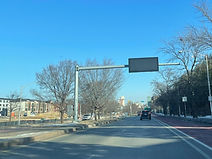
A new variable message sign then extends overhead from the median. Photo taken 01-15-2025.

Park Avenue is intersected along the north end of Bolton Hill. Photo taken 01-15-2025.

US 1 is now 500 feet away from meeting Interstate 83, which is known in Baltimore as the Jones Falls Expressway (JFX) after the harbor tributary it parallels and, at points, runs over top of. On this aging sign, the I-83 shield is faded beyond recognition. Photo taken 01-15-2025.

The onramp from US 1 to I-83 north contains separate access to eastbound 28th Street and westbound Druid Park Lake Drive, the two intersecting streets of I-83's exit 7 just to the north. On I-83 north, exits 6 (US 1) and 7 share the same jumping-off point. A cloverleaf ramp leads from there to US 1 beside the North Avenue light rail station. Photo taken 01-15-2025.

At this signal, where the ramp to I-83 north is to the left, Mount Royal Avenue goes south (right) and then east as it takes a winding path parallel to I-83, eventually turning south again and splitting into two one-way streets, Guilford Avenue (southbound) or Fallsway (northbound). Photo taken 01-15-2025.

The ramp to I-83 south sits almost directly underneath I-83's crossing of North Avenue. Photo taken 01-15-2025.
