
The epzik8 Webpage
South Carolina Highway 31 south

South Carolina Highway 31 (Carolina Bays Parkway) proceeds south from its northern terminus at South Carolina Highway 9 near Little River, South Carolina. (7-17-2025)

An SC 31 reassurance shield sits to the right. (7-17-2025)

The speed limit along most of the highway is 65 miles per hour. (7-17-2025)

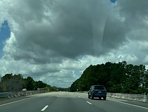
Soon, the highway has a pair of bridges over swampland. (7-17-2025)

The cities of Myrtle Beach and Georgetown are a respective 22 and 56 miles from the green sign to the right. (7-17-2025)

More locally, interchanges with South Carolina Highway 22, Grissom Parkway, and U.S. Route 501 are 7, 12 and 18 miles away. (7-17-2025)

There is then another swamp bridge. (7-17-2025)

In one mile, there is an interchange with the Robert Edge Parkway which leads toward the Ocean Drive Beach section of North Myrtle Beach. (7-17-2025)

Food options at the exit are displayed to the right. (7-17-2025)

The exit also leads to the North Myrtle Beach Sports Complex. (7-17-2025)

SC 31 has a bridge over SC 90 just prior to the exit. (7-17-2025)

The Robert Edge Parkway exit lies just ahead. Opened in 2009, the parkway links SC 90 with U.S. Route 17, where it becomes North Myrtle Beach's Main Street, and has a bridge over the Intracoastal Waterway to the east. (7-17-2025)

SC 31 shortly passes over the parkway. (7-17-2025)

Southbound SC 31 then receives Robert Edge Parkway traffic from the onramp at right as it curves gradually to the right. (7-17-2025)

One more bridge over swamp is on the other side of the curve. (7-17-2025)

Bourne Trail crosses the highway next. (7-17-2025)

There is then a wide curve to the left. (7-17-2025)

Myrtle Beach is served by the next 3 exits, the distances of which are covered by a tree on the sign to the right. (7-17-2025)

Club Course Drive, one of the main roads in the Barefoot residential golf community and resort in lower North Myrtle, passes over SC 31 between exits. (7-17-2025)

SC 31's interchange with SC 22 (Conway Bypass) is a mile away. Unlike other guide signs along SC 31 that bear the new South Carolina state highway shield design introduced in 2009, this sign still bears the old shield design. (7-17-2025)

Access to SC 22 from southbound SC 31 begins as a single ramp which then splits into two separate ramps to each direction of SC 22. (7-17-2025)

The southbound SC 22 exit gore is partially situated over a crossing of Marsh Glen Drive. Photo taken 07-17-2025.

Seen here is the flyover ramp from SC 31 south to SC 22 east. Photo taken 07-17-2025.

Behind the flyover from SC 31 north to SC 22 west, SC 31 crosses SC 22. Just to the southeast, SC 22's ending interchange at US 17 contains two separate ramps to Kings Road which respectively lead to the Myrtle Beach Mall and Tanger Outlets. This interchange is also rumored to be the future southern terminus of Interstate 73. Photo taken 07-17-2025.

SC 31's next interchange after SC 22 is at Watertower Road. Photo taken 07-17-2025.

The Watertower Road exit is ahead to the right. Photo taken 07-17-2025.

Within the interchange, SC 31 crosses Long Branch, an Intracoastal Waterway tributary. Photo taken 07-17-2025.

Watertower Road passes overhead here. Photo taken 07-17-2025.

After Watertower Road there is SC 31 reassurance. Photo taken 07-17-2025.

Important attractions in Myrtle Beach are listed by the sign to the right as SC 31 makes its closest approach to the core of the area. Photo taken 07-17-2025.

The highway soon has a wide curve to the right. Photo taken 07-17-2025.

After straightening out, it reaches mile marker 12. Photo taken 07-17-2025.

The portion of the US 17 corridor running between 38th and 82nd Avenues North in Myrtle Beach can be reached by taking the second exit up ahead. Photo taken 07-17-2025.

The first offramp leads to International Drive, while the second leads to Grissom Parkway half a mile away. Photo taken 07-17-2025.

The Grissom Parkway ramp is on the other side of the International Drive overpass. Photo taken 07-17-2025.

The Grissom Parkway offramp is a tight cloverleaf. Photo taken 07-17-2025.
The highway subsequently crosses River Oaks Drive. Photo taken 07-17-2025.

The speed limit remains 65 miles per hour. Photo taken 07-17-2025.

SC 31 will reach its interchange with US 501 in one mile. US 501 leads north toward Conway and south toward its southern terminus in downtown Myrtle Beach. Photo taken 07-17-2025.

Some of the food options along US 501 are listed by this blue sign. Photo taken 07-17-2025.

SC 31 crosses McNair Boulevard, which dead-ends a few feet to the north, before reaching US 501. Photo taken 07-17-2025.

Fantasy Harbor can be reached by taking the next left at US 501 south. Photo taken 07-17-2025.

The speed limit drops to 50 on approach to the interchange. Photo taken 07-17-2025.

Prior to the interchange, SC 31 goes over the Socastee Swamp. Photo taken 07-17-2025.

The movement from SC 31 south to US 501 south is a left exit. Photo taken 07-17-2025.

Coastal Carolina University and Horry-Georgetown Technical College can both be reached from US 501 north. Photo taken 07-17-2025.

This is a unique "fishbowl" interchange where SC 31's carriageways split apart and about half of the movements between the two highways are located in the gap in the middle of SC 31. Photo taken 07-17-2025.

The ramp from SC 31 south to US 501 north, meanwhile, is a short right exit, and begins just as SC 31 curves sharp left. Photo taken 07-17-2025.

The highway proceeds over US 501 at this point. Photo taken 07-17-2025.

At right, SC 31 south collects traffic from US 501 south. Photo taken 07-17-2025.

A long cloverleaf onramp from US 501 north reaches SC 31 south on the left. Photo taken 07-17-2025.

Now that US 501 is in the rearview, the speed limit goes back up to 65. Photo taken 07-17-2025.

One mile away, SC 31 has an interchange at South Carolina Highway 544 (Dick Pond Road), which goes west toward Conway and east to Surfside Beach. Photo taken 07-17-2025.

The offramp to SC 544 is ahead on the right. While SC 31 was complete and opened from SC 9 to here by 2005, the remaining couple of miles beyond here did not open until August 2019, largely owing to environmental and funding issues. Photo taken 07-17-2025.

Each direction of SC 544 has its own offramp to it. The ramp to SC 544 west is on the right. Photo taken 07-17-2025.

SC 31 subsequently crosses over SC 544. Photo taken 07-17-2025.

A SC 31 reassurance shield follows SC 544. Photo taken 07-17-2025.

SC 31's end at SC 707 is 3 miles ahead, and Georgetown is 32 miles away via SC 707, Holmestown Road and US 17. Photo taken 07-17-2025.
SC 31's end at SC 707 is 3 miles ahead, and Georgetown is 32 miles away via SC 707 and US 17. Photo taken 07-17-2025.

There is subsequently a bridge over the Intracoastal Waterway, taking SC 31 onto the Atlantic side of the waterway. Photo taken 07-17-2025.

¾ of a mile before the end of the left lane, the highway passes under Enterprise Road with a marked vertical clearance of 17 feet, 9 inches. Photo taken 07-17-2025.

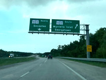
SC 707, which bears control cities of Murrells Inlet and Georgetown, is a mile away. Photo taken 07-17-2025.

The speed limit drops to 50 up ahead. Photo taken 07-17-2025.

There is a bridge over a canal before the highway's end. Photo taken 07-17-2025.
SC 31 now reaches its end at SC 707. Photo taken 07-17-2025.