
The epzik8 Webpage
Maryland Route 4 north - Sunderland to Upper Marlboro

Between Huntingtown and Dunkirk in Calvert County, northbound Maryland Route 4 (Southern Maryland Boulevard) pulls away from its intersection with Fowler Road. Photo taken 04-09-2025.

The current speed limit is 55 miles per hour. Photo taken 04-09-2025.

Intersected ahead on right is Bright Lane which goes into the subdivision MacDonald Farms. Photo taken 04-09-2025.

The highway then glides downhill. This portion of MD 4 has several significant changes in elevation, and in some cases, these are different for each carriageway in the same spot. Photo taken 04-09-2025.

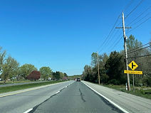
Ahead, Mount Harmony Road goes off to the east and connects with Maryland routes 2 and 260. Photo taken 04-09-2025.

Mount Harmony has its own turn lane onto MD 4 north. Photo taken 04-09-2025.

Dunkirk Drive is then intersected at the bottom of another hill. Photo taken 04-09-2025.

The highway rides a lefthand curve downhill, and an MTA park and ride facility (served by bus 830 to Washington, DC) is a mile away. Photo taken 04-09-2025.

The route starts back uphill, crosses Hall Creek, and approaches Cortland Lane. Photo taken 04-09-2025.

Ahead, the speed limit lowers to 45. Photo taken 04-09-2025.

At this time, MD 4 makes its way into Dunkirk, a burgeoning exurban community in northern Calvert County. Photo taken 04-09-2025.

Up ahead, Apple Way heads into the Apple Greene subdivision. Photo taken 04-09-2025.

The route will intersect Ward Road at a signal in the distance. Photo taken 04-09-2025.

Ward Road cuts between Dunkirk's various retail and residential areas; at right, it accesses the Southern Memorial Gardens and the Ward Farm. Photo taken 04-09-2025.

MD 4 reassurance follows Ward Road. Photo taken 04-09-2025.

At right, Penwick Lane is intersected opposite Ferry Landing Lane. Photo taken 04-09-2025.

Ahead to the left, there is a state farmers market which was closed for the season. Photo taken 04-09-2025.

The other signal in Dunkirk is at Town Center Boulevard. Photo taken 04-09-2025.

This light serves the Dunkirk Gateway shopping center and the Dunkirk District Park. Photo taken 04-09-2025.

Now leaving Dunkirk, MD 4 prepares to intersect Yellow Bank Road. Photo taken 04-09-2025.

The highway curves slightly before coming to Brickhouse Road, the main road into Country Road Estates. Photo taken 04-09-2025.
Ahead, Cedarwood Lane leads into the development of the same name. Photo taken 04-09-2025.

The next intersection is at Morning Glory Lane. Photo taken 04-09-2025.
Lyons Creek Road serves the developments of Regal Estates and Patuxent Palisades to the immediate west. Photo taken 04-09-2025.

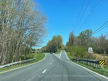
The route has been oriented straight for a while, but now there is a wide curve to the right. Photo taken 04-09-2025.

Toward the end of the curve sits Dunleigh Drive. Photo taken 04-09-2025.

The northbound carriageway goes uphill, then has a very short hillcrest before descending. Photo taken 04-09-2025.

Chaney Road, another area collector, is up ahead. Photo taken 04-09-2025.

Though MD 4's intersection with Chaney Road is not fully signalized, it does contain a set of flashers. Photo taken 04-09-2025.

This is followed by a MD 4 reassurance shield. Photo taken 04-09-2025.

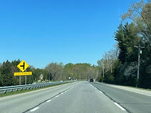
The route will soon intersect Maryland Route 260 at a partial interchange, with no access from MD 260 west to MD 4 south. Photo taken 04-09-2025.

The MD 260 marker at right indicates its western terminus is at said interchange. Photo taken 04-09-2025.

MD 260 leads to Chesapeake Beach and North Beach - Calvert County's only two incorporated municipalities - and their associated recreational areas. Photo taken 04-09-2025.

This ramp gore sign points the way to MD 260. Photo taken 04-09-2025.

MD 260 subsequently flies over MD 4 using this overpass, and as northbound traffic prepares to exit Calvert County, there is a county welcome sign facing in the other direction (southbound). Photo taken 04-09-2025.

To the right, traffic coming in from MD 260 west defaults onto MD 4 north. Photo taken 04-09-2025.

On this note, MD 4 crosses Lyons Creek into Anne Arundel County. Photo taken 04-09-2025.

The Patuxent tourism corridor and Upper Marlboro area are located straight ahead on MD 4. Photo taken 04-09-2025.

Return access to MD 4 south, with a control city of Prince Frederick, is at the next left at Lower Pindell Road. Photo taken 04-09-2025.

At right across from Lower Pindell is Fishers Station Road. Photo taken 04-09-2025.
The route now heads into a well-forested area. Photo taken 04-09-2025.

To the right, an extended right-turn lane from Fishers Station reaches MD 4. Photo taken 04-09-2025.

With a wide median, MD 4 dips downward, still surrounded by trees. Photo taken 04-09-2025.

The highway then twists to the right. Photo taken 04-09-2025.

When activated, this set of overhead flashers warns drivers to watch for stopped traffic as there is an approaching intersection with low visibility. Photo taken 04-09-2025.

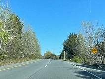
Maryland routes 258 and 259, leading toward the Bristol and Deale areas of Anne Arundel's South County region, are intersected by MD 4 in half a mile. Photo taken 04-09-2025.

One of the roads met at the interim intersection, ¼ mile away, is Talbott Road. Photo taken 04-09-2025.

Also intersected ahead is access to a Service Road, which runs along MD 4's southbound carriageway. Photo taken 04-09-2025.

The street blade at the intersection spells Talbott as "Talbot", and its blue color indicates its maintenance is private and not provided by the county. Photo taken 04-09-2025.
The offramp ahead is marked as leading to MD 258. Photo taken 04-09-2025.

MD 4 curves wide left at the ramp gore. A right turn at the end of the ramp puts one on MD 258; going straight is a movement onto MD 259. Photo taken 04-09-2025.

MD 4 now becomes a full-fledged freeway designated the Stephanie Roper Highway, after a Frostburg University student who was kidnapped and murdered near here in 1982. Southern Maryland Boulevard, however, remains the highway's official name. Photo taken 04-09-2025.

MD 258 uses this bridge to pass over MD 4. Photo taken 04-09-2025.

The northbound carriageway receives an onramp from the two intersected routes on the right. Photo taken 04-09-2025.

MD 4 orients itself northwest at this time, with mild changes in elevation. Photo taken 04-09-2025.

An access point to the northbound service road is half a mile away. Photo taken 04-09-2025.

A quarter mile past that sits signage for an exit leading toward Maryland Route 408 and Waysons Corner. Photo taken 04-09-2025.

In the meantime sits MD 4 signage. Photo taken 04-09-2025.

There is a hard right turn onto the service road. Photo taken 04-09-2025.

This exit sign sits in the ramp gore. Photo taken 04-09-2025.

A park and ride can be reached from the next ramp. Photo taken 04-09-2025.

In the other direction, MD 408 has an additional control city of Annapolis via MD 2. Photo taken 04-09-2025.

MD 4 curves due west and comes within half a mile of Old Marlboro Pike. Photo taken 04-09-2025.

Traffic enters from MD 408 ahead at right. Photo taken 04-09-2025.

On the next advance sign, the intersecting road name is given as simply Marlboro Pike. Photo taken 04-09-2025.

Marlboro Pike sits straight ahead. Photo taken 04-09-2025.

Immediately prior to the exit, MD 4 crosses the Patuxent River into Prince George's County, thereby entering the greater Washington, DC area. Photo taken 04-09-2025.

MD 4 will meet U.S. Route 301 (Crain Highway) at an eight-ramp cloverleaf interchange in one mile. Photo taken 04-09-2025.

An exit marked as simply leading to Prince George's seat Upper Marlboro is 1¼ miles from this overhead gantry, and half a mile past US 301. Photo taken 04-09-2025.

The Upper Marlboro exit leads to county offices, the District Court, and a park and ride from which county and MTA buses lead to, among other places, Largo, a more centrally-located area where some other Prince George's government offices have relocated to in the hopes of making Largo the new county seat. Photo taken 04-09-2025.

A sign at the right states bicycles are no longer permitted on the shoulder. Photo taken 04-09-2025.

Southbound interests along US 301 include the Patuxent and Potomac tourist corridors. Photo taken 04-09-2025.

US 301 north leads to Baltimore via Maryland Route 3, Interstates 97 and 695, and Maryland Route 295. Photo taken 04-09-2025.

The northbound US 301 ramp gore. Photo taken 04-09-2025.

Before MD 4 crosses US 301, the cross street of the Upper Marlboro exit is finally revealed: Maryland Route 717, Water Street. Photo taken 04-09-2025.
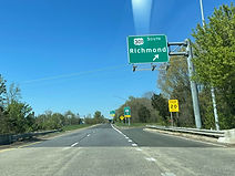
A cloverleaf ramp then leads from MD 4 north to US 301 south which has a control city of Richmond, Virginia. Photo taken 04-09-2025.
