
The epzik8 Webpage
Maryland Route 213 south - Elkton to Galena

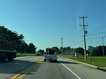
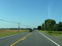
Maryland Route 213 (Augustine Herman Highway) pulls away from U.S. Route 40 (Pulaski Highway) on the south side of Elkton in Cecil County, with Chesapeake City 6 miles away, Galena 20, and Chestertown 36. Photo taken 06-24-2025.

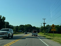
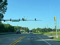
The route is coming up on a traffic signal at White Hall Road. Photo taken 06-24-2025.

White Hall Road goes west (right) into the subdivision of White Hall, and northeast back to US 40. Photo taken 06-24-2025.

MD 213 reassurance follows the signal. Photo taken 06-24-2025.

A park and ride is ahead on the left. Photo taken 06-24-2025.

The route will soon meet Frenchtown Road at a crossroads. Photo taken 06-24-2025.

Frenchtown Road goes a few miles east into Delaware. Photo taken 06-24-2025.

Lewis Shore Road is intersected at another crossroads soon afterward. Photo taken 06-24-2025.

After emerging from the trees, the route approaches a signal at Williams Road (left) and Locust Point Road (right). Photo taken 06-24-2025.

Williams Road is another road leading into Delaware, doing so as Old County Road. Photo taken 06-24-2025.
The signal is followed by more MD 213 reassurance. Photo taken 06-24-2025.
Elk Forest Road is intersected straight ahead. Photo taken 06-24-2025.

The Elk Forest intersection is augmented by a flashing beacon. Photo taken 06-24-2025.

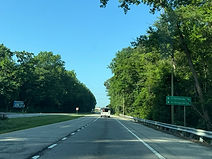
The route then continues through another covering of trees. Photo taken 06-24-2025.

Spears Hill Road is intersected ahead. Photo taken 06-24-2025.

The C&D Canal Trail can then be accessed to the left. Photo taken 06-24-2025.

MD 213 is now about to intersect Maryland Route 285. Photo taken 06-24-2025.
MD 285 leads into North Chesapeake City. Photo taken 06-24-2025.

After that junction, signs for Maryland's Chesapeake Country Scenic Byway, which includes this portion of MD 213, begin appearing. Photo taken 06-24-2025.

MD 213 then ascends to the Chesapeake City Bridge over the Chesapeake and Delaware Canal, which begins here. Photo taken 06-24-2025.

The bridge's defining feature is this center overhead truss. Photo taken 06-24-2025.

The highway then glides back down toward land. Though not representing the opinion of the majority, Peter personally considers the C&D Canal the beginning of Maryland's Eastern Shore and the Delmarva Peninsula. Because the canal runs seamlessly between its namesake Chesapeake Bay and Delaware River, the "peninsula" actually amounts to being an island. Photo taken 06-24-2025.

After the bridge ends, the brown sign to the right points the way to the historic (south) region of Chesapeake City. Photo taken 06-24-2025.

This right-in/right-out leads to Basil Avenue, which leads toward Maryland routes 286 and 342 and passes under the south end of the bridge while at it. Photo taken 06-24-2025.

There is then MD 213 reassurance. Photo taken 06-24-2025.

The route goes on to intersect Randalia Road. Photo taken 06-24-2025.
Afterward, a state "historic towns" sign for Chestertown states the Kent County seat as being 28 miles away. Photo taken 06-24-2025.

The route will then intersect Basil Avenue, followed by the entrance to Bohemia Manor High School and Chesapeake City Elementary School. Photo taken 06-24-2025.
There is a traffic signal at the school entrance owing to the large volume of school bus and student traffic on school days. Only the high school is marked on the mast arm of the signal, as the current iteration of the elementary school is years newer, having opened in 2021. Photo taken 06-24-2025.

Intersected next is Court House Point Road. Photo taken 06-24-2025.

The highway then has a slight dip with trees on either side. Photo taken 06-24-2025.

Soon afterward, a sign within a lefthand curve warns of left turning vehicles ahead. Photo taken 06-24-2025.

At an S-curve, the route meets a connector to Maryland Route 310 (Cayots Corner Road). Photo taken 06-24-2025.

MD 310 itself is then intersected at a signal. Photo taken 06-24-2025.
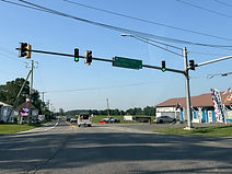
The westbound leg of this intersection is Town Point Road. Photo taken 06-24-2025.

This is followed by more MD 213 reassurance. Photo taken 06-24-2025.

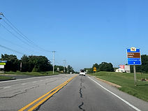
The towns of Cecilton and Galena are a respective 7 and 12 miles away. Photo taken 06-24-2025.
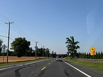
The next 5 miles of the highway are a deer crossing area. Photo taken 06-24-2025.

Drivers then have to deal with a pair of wide curves to the right. This is the second of the two. Photo taken 06-24-2025.

A left turn up ahead leads one to the Bohemia River State Park. Photo taken 06-24-2025.

The route goes on past the Bohemia Manor Farm, which has a vineyard and winery on-site. Photo taken 06-24-2025.

The highway curves left as it nears the Bohemia River. Photo taken 06-24-2025.

The Bohemia is a tributary of the Elk River, which in turn is an inlet into the Chesapeake Bay. Photo taken 06-24-2025.

Glebe Road is intersected ahead to the right. Photo taken 06-24-2025.

Glebe Road leads to the community of Hacks Point and the Long Point Marina. Photo taken 06-24-2025.

The route then makes its way past trees and a cornfield. Photo taken 06-24-2025.

It then straightens out as it emerges back into open land. Photo taken 06-24-2025.

After a lefthand curve, there is a dip in the road. Photo taken 06-24-2025.

Intersected to the left, Bohemia Church Road leads toward the town of Warwick to the east. Photo taken 06-24-2025.

The next intersection is at Mill Lane. Photo taken 06-24-2025.

Soon afterward, the highway prepares to enter Cecilton. Photo taken 06-24-2025.

The historic Mount Harmon Plantation is a right turn away at the forthcoming traffic signal. Photo taken 06-24-2025.

MD 213 then enters Cecilton town limits. Photo taken 06-24-2025.

The speed limit through Cecilton is 30 miles per hour. Photo taken 06-24-2025.
A left turn at the signal leads to Warwick, while going right leads to Earleville. Meanwhile, a speed trap in the distance enforces the town speed limit. Photo taken 06-24-2025.

The route intersected at the signal is Maryland Route 282 (Main Street). Photo taken 06-24-2025.

Eastbound MD 282 goes all the way into Delaware where it becomes Delaware Route 299, passing through Middletown and Odessa. Photo taken 06-24-2025.

There is MD 213 reassurance on the other side of the signal. Photo taken 06-24-2025.

The route goes on to curve wide right. Photo taken 06-24-2025.

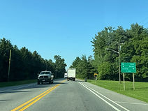
Galena is now 4 miles away. Photo taken 06-24-2025.

The highway leaves Cecilton, and the speed limit becomes 40 miles per hour. Photo taken 06-24-2025.

Chestertown is situated 19 miles ahead. Photo taken 06-24-2025.
The route curves right, then continues straight. Photo taken 06-24-2025.

The route curves right again at the entrance to the historic Greenfield estate. Photo taken 06-24-2025.

It goes on to intersect Sandy Bottom Road. Photo taken 06-24-2025.

The speed limit drops to 40 up ahead. Photo taken 06-24-2025.

There is also a drawbridge in ¼ mile. Photo taken 06-24-2025.

MD 213 now enters the community of Fredericktown. Photo taken 06-24-2025.

The speed limit is now down to 30 miles per hour. Photo taken 06-24-2025.

The route goes on to intersect Union Folly Road. Photo taken 06-24-2025.

These flashers warn of the drawbridge ahead. Photo taken 06-24-2025.

At School House Lane, just before it makes its descent to the Sassafras River, MD 213 bears left. Photo taken 06-24-2025.

The final intersection in Cecil County is at George Street. This sign also points left toward the Fredericktown post office. Photo taken 06-24-2025.

MD 213 now begins its crossing of the Sassafras. Photo taken 06-24-2025.
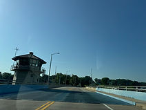
The drawbridge control tower is roughly at the middle of the bridge, and a blue-painted metal grate opens whenever an overheight vessel needs to get through. A traffic signal just behind the tower turns red to stop traffic when the bridge opens. Photo taken 06-24-2025.

On the other side of the bridge, MD 213 enters Kent County and Georgetown, a twin community to Fredericktown. Photo taken 06-24-2025.

The route now climbs uphill, away from the Sassafras. Photo taken 06-24-2025.

The highway soon leaves Georgetown and passes Toal Park. Photo taken 06-24-2025.

After a righthand curve, the route's speed limit drops down to 35 miles per hour. Photo taken 06-24-2025.

Interests to Chestertown are directed to turn right at the signal a distance ahead. Photo taken 06-24-2025.

MD 213 now makes its entry into Galena. Photo taken 06-24-2025.

Drivers headed to U.S. Route 301 can go straight ahead at the signal, while the community of Sassafras is to the left. Photo taken 06-24-2025.

The route soon intersects Dogwood Drive on the right. Photo taken 06-24-2025.

The Massey Air Museum in the nearby town of Massey is straight ahead. Photo taken 06-24-2025.

At the signal at the center of Galena, MD 213 turns off to the right, Maryland Route 313 (Main Street) begins, and northbound Maryland Route 290 is to the left. MD 313 and MD 290 overlap for about a mile before MD 290 branches off, with MD 313 then continuing south to US 301. Photo taken 06-24-2025.