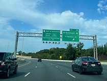
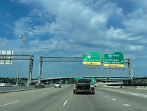
Interstate 95 south - Baltimore

Interstate 95 parts ways with Interstate 895 (Harbor Tunnel Thruway) at exit 62 as it enters Baltimore from the northeast, as seen here. I-895 is an alternative (and older) freeway routing passing south of downtown Baltimore with a tunnel crossing of the tidal Patapsco River; I-95 uses the Fort McHenry Tunnel. Photo taken 08-11-2024.

The highway begins curving left and will pass under a flyover leading from I-895 north to I-95 north. Photo taken 08-11-2024.

I-95 passes under the aforementioned movement here. Photo taken 08-11-2024.

It then passes under a ramp tying into I-95's median express lanes that run in both to around mile marker 68, just north of the White Marsh exit about seven miles away, then northbound only to MD 152 (Fallston/Joppa) in Harford County after another seven miles. Photo taken 08-11-2024.

Now with the highway facing due south, southbound express traffic enters the main carriageway at left, and there are I-95 shields on each side. Photo taken 08-11-2024.

The Baltimore Travel Plaza - a combination truck stop and hotel - is off exit 57 a few miles away, along with the Canton and Fells Point sections of east Baltimore. Photo taken 08-11-2024.

The current speed limit is 55 miles per hour. Photo taken 08-11-2024.

A sign in the median then welcomes drivers a few miles in advance to the Fort McHenry Tunnel. Photo taken 08-11-2024.

At right, an onramp enters from westbound U.S. Route 40 (Pulaski Highway) which is accessible from I-95 north at exit 61. Photo taken 08-11-2024.

I-95 crosses over US 40 here. US 40 was one of the routes in Baltimore that was functionally replaced by I-95 and I-895. Photo taken 08-11-2024.

I-95 will reach Eastern Avenue (Maryland Route 150) at exit 59 in one mile. Photo taken 08-11-2024.

Seen here is a flyover carrying westbound Moravia Road over the highway. This forms part of northbound exit 60. Eastbound Moravia has separate access to westbound US 40 just to the west, to facilitate this movement for drivers coming from I-95 south via exit 14 of I-895. Photo taken 08-11-2024.

Next, there is a crossing of a CSX freight line. Photo taken 08-11-2024.

I-95 commences a viaduct before it receives traffic from eastbound Moravia. Photo taken 08-11-2024.

Tunnel restrictions are posted alongside the final advance sign for exit 59. Meanwhile, I-95 is currently crossing over Erdman Avenue (MD 151) as well as Amtrak's Northeast Corridor, which also facilitates MARC's Penn Line within Baltimore. Photo taken 08-11-2024.

Exit 59 sits just behind a footbridge. Photo taken 08-11-2024.

Before the Eastern Avenue overpass, there is signage for exit 57 (O'Donnell Street/Boston Street) and E-ZPass administration and police at exit 56. Photo taken 08-11-2024.

I-95 receives a cloverleaf onramp from Eastern Avenue, then curves sharp right. Photo taken 08-11-2024.

The onramp from Eastern Avenue is at right. Photo taken 08-11-2024.

Another viaduct then commences. Photo taken 08-11-2024.

Exit 57 is ¼ mile away. Photo taken 08-11-2024.

Exit 57 lies ahead. This assembly also includes signage for the Locust Point and Fairfield/Masonville terminals of the Port of Baltimore, the former also acting as Baltimore's cruise terminal, at exit 55 after the tunnel. Photo taken 08-11-2024.

Tunnel toll rates are displayed here. All Maryland tollbooths went cashless in 2020. Photo taken 08-11-2024.

The exit 57 gore sign. Photo taken 08-11-2024.

Exit 56, intersecting Keith Avenue, is the last before the tunnel. There is also signage for two two major league sports stadiums at Camden Yards - Oriole Park at Camden Yards, and M&T Bank Stadium (Ravens) - accessible from exits 55 and 53, and the BWI airport via exits 52 and 47. Photo taken 08-11-2024.

The toll scanners are 1¼ miles away. Photo taken 08-11-2024.

At a righthand curve, I-95 picks up an onramp from Boston Street and is about to pass over I-895. Photo taken 08-11-2024.

The southbound lanes divide into two separate carriageways for two tunnel bores in half a mile. Photo taken 08-11-2024.

Exit 56 sits ahead. This is the last chance for hazmat vehicles to exit; such vehicles have occasionally been caught taking the tunnels in the wake of the 2024 collapse of the Francis Scott Key Bridge along the Baltimore Beltway (I-695). Photo taken 08-11-2024.

At the exit 56 gore sign, there is two-mile advance signage for exit 55, Key Highway leading to the tunnel's namesake Fort McHenry. Photo taken 08-11-2024.

The lanes divide ¼ mile before the toll scanners. There is also a sign stating various points in west Baltimore can be reached from exit 53. Photo taken 08-11-2024.

No lane-changing is permitted in the tunnel. Photo taken 08-11-2024.

This is the northern entrance to the Fort McHenry Tunnel, which opened in 1985 and took a significant amount of traffic out of the Harbor Tunnel on I-895. Photo taken 08-11-2024.

Another "STAY IN LANE" marker is within the tunnel. Photo taken 08-11-2024.

The end of the tunnel can be seen here. Photo taken 08-11-2024.

The Interstate emerges from the tunnel, but there is still no passing for the time being. Photo taken 08-11-2024.

Exit 55 comes before the lanes merge, and is thus only accessible to southbound traffic from the right tunnel bore. Photo taken 08-11-2024.

The exit 55 gore sign is at right. Photo taken 08-11-2024.

The lanes have now merged. Photo taken 08-11-2024.

Exit 53, one mile away, intersects Interstate 395, leading to downtown Baltimore and the Inner Harbor. Along with the stadiums, it can also be used to reach the city's convention center. Photo taken 08-11-2024.

Half a mile later, signage begins appearing for exit 52, intersecting Maryland Route 295 (Baltimore-Washington Parkway south), along with reiteration of the BWI airport exits. At right, I-95 south receives an onramp from Hanover Street (Maryland Route 2), which I-95 north accesses by way of exit 54. Photo taken 08-11-2024.

Exit 53 is half a mile before exit 52. Photo taken 08-11-2024.

Overhead signage for each exit is up ahead. Photo taken 08-11-2024.

The exit 53 gore sign. I-395 ends at Conway Street, beside the Camden MARC station and Eutaw Street, and becomes Howard Street. Photo taken 08-11-2024.

Exit 52 is now impending, and I-95 now has a posted control city of Washington. Photo taken 08-11-2024.

The exit 52 gore sign. The B-W Parkway runs alongside I-95 to the northeastern suburbs of Washington, DC. Meanwhile, a flyover ramp from I-95 north to I-395 north up ahead is marked as Cal Ripken Way, in honor of the Baltimore Orioles baseball great. Photo taken 08-11-2024.

At right as southbound traffic from I-395 enters sits the controversial Wheelabrator property. Photo taken 08-11-2024.

The long ramp to MD 295 south is seen at right. Photo taken 08-11-2024.

I-95 next receives traffic from southbound Russell Street. Photo taken 08-11-2024.

Exit 50, at Caton Avenue, is a mile away. Photo taken 08-11-2024.

Meanwhile, Interstate 195, the other access point to BWI from I-95, is 4 miles and 5 minutes away. Photo taken 08-11-2024.

As the highway passes over Washington Boulevard, accessed northbound at exit 51, there is I-95 reassurance. Photo taken 08-11-2024.

At the half-mile sign for exit 50, there is two-mile advance notice for exit 49, the southern of I-95's two interchanges with Interstate 695, leading toward Towson and Glen Burnie. Photo taken 08-11-2024.

The far-right lane is reserved for Caton Avenue. Photo taken 08-11-2024.

A collector-distributor leads from here to each offramp of exit 50. Photo taken 08-11-2024.

The exit 50 gore sign. Photo taken 08-11-2024.

There is then signage warning of I-695 east (outer loop) being closed at exit 1 at Hawkins Point, due to the Key Bridge collapse. Photo taken 08-11-2024.

Exit 49A (also the outer loop) can be used to backtrack to the Baltimore-Washington Parkway as well as to reach southbound Interstate 97 toward Annapolis. Photo taken 08-11-2024.

Exit 50B is ahead at far right. Photo taken 08-11-2024.

Caton Avenue passes over I-95 here. Photo taken 08-11-2024.

Exit 50A is then seen at right. Photo taken 08-11-2024.

Exit 49B, leading to I-695 west (inner loop) toward Interstate 70 and Towson, is ¾ mile away. Photo taken 08-11-2024.

Exit 49A, with an additional control city of Annapolis, is a left exit; meanwhile, Joh Avenue passes overhead. Photo taken 08-11-2024.

Exit 49B is at right, and a shield in the median indicates exit 49A as leading to MD 295. Photo taken 08-11-2024.

The exit 49B gore sign. Photo taken 08-11-2024.

Exit 49A is ahead at left, two miles prior to exit 47 at I-195 and Maryland Route 166. Photo taken 08-11-2024.
