
The epzik8 Webpage
Interstate 95 north - Baltimore

After its interchange with Interstate 695 (Baltimore Beltway) in Arbutus, Baltimore County, Interstate 95 goes north toward the Baltimore city line and is half a mile from exit 50, at Caton Avenue. Photo taken 04-30-2025.

Travel times to I-395 and the Fort McHenry Tunnel under the tidal Patapsco River are displayed by this overhead message sign. Photo taken 04-30-2025.

I-95 enters Baltimore, and the Maryland Transportation Authority assumes control from the State Highway Administration. Photo taken 04-30-2025.

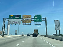
At Caton Avenue, there is signage billing points in West Baltimore, along with the University of Maryland Medical Center (UMMC) and University of Maryland in Baltimore (UMB) being reachable from exit 52. Photo taken 04-30-2025.

Exit 50 is split into 50A for Caton Avenue south and 50B for Caton Avenue north. Photo taken 04-30-2025.

Following exit 50B, on the other side of the Caton Avenue overpass, sits an inspection station for heavy-duty vehicles in anticipation of the tunnel. Exit 51 with Washington Boulevard is a mile away, while exit 55 (the last before the tunnel) services the Locust Point terminal of the Port of Baltimore, which is also the city's cruise terminal. Photo taken 04-30-2025.

Two miles away, Interstate 395 (Cal Ripken Way) makes its way toward downtown Baltimore and the Inner Harbor from exit 53. From exits 52 and 53, the sports stadiums at Camden Yards - Oriole Park and M&T Bank Stadium (Ravens) - can be reached, and the latter can also be used to access the city's Johns Hopkins hospital. Photo taken 04-30-2025.

Drivers of hazmat vehicles must exit no later than exit 55 because hazmats are prohibited in the tunnel. Photo taken 04-30-2025.

I-95 then crosses Desoto Road which runs through the Morrell Park neighborhood of southwest Baltimore. Photo taken 04-30-2025.

This stretch of I-95 is dedicated to MDTA police corporal Courtney Brooks, who died in a hit and run near here in 2008. Photo taken 04-30-2025.

Half a mile past exit 51, I-95 has access to northbound Russell Street at exit 52. Photo taken 04-30-2025.

This sign points the way to exit 51, which is located above CSX's Mount Clare rail yard and near the point where Interstate 70 was supposed to end at I-95 in the 1960s prior to Baltimore's freeway revolts. Photo taken 04-30-2025.

The exit 51 gore sign. Photo taken 04-30-2025.

At exit 51, exit 52 sits half a mile away and exit 53 comes in one mile. Photo taken 04-30-2025.

At this time I-95 crosses Washington Boulevard. Photo taken 04-30-2025.

Another point of interest served by exit 52 is the Horseshoe Casino. Photo taken 04-30-2025.

Additional signage for Camden Yards is given for exits 52 and 53, with the latter also leading to the Baltimore Convention Center. Photo taken 04-30-2025.

As lanes for exit 53 are delineated, exit 52 is reached, its number coinciding with the jersey number of legendary Ravens linebacker Ray Lewis. Photo taken 04-30-2025.

At exit 52, the city's Wheelebrator property is located to the left. The southbound offramp for exit 52 leads to southbound Maryland Route 295, the Baltimore-Washington Parkway, which begins at this interchange and which Russell Street is a continuation of. Photo taken 04-30-2025.
One mile past exit 53 sits exit 54, with southbound Maryland Route 2 (Hanover Street). At far left, the toll rates for the tunnel are posted. Photo taken 04-30-2025.

The Interstate now comes upon exit 54. In three miles, I-95 will reach the Fort McHenry Tunnel. Photo taken 07-15-2024.

Following Hanover Street is exit 55, intersecting Key Highway leading to the Fort McHenry National Monument. Photo taken 07-15-2024.

Exit 53 now appears. At its north end at Conway and Howard streets, I-395 contains one of the few traffic lights in the Interstate system. Photo taken 04-30-2025.

The ramp to Key Highway sits just ahead. The tunnel is now 2½ miles away. Photo taken 07-15-2024.

The exit 55 ramp gore sign. Photo taken 07-15-2024.

I-95 is now officially a tolled facility as it approaches the tunnel. Photo taken 07-15-2024.

The first exit after the tunnel, 56 (Keith Avenue), is 2½ miles away. That exit leads to EZPass' administrative offices along with Maryland Transportation Authority police. Photo taken 07-15-2024.

The Dundalk and Seagirt terminals of the Port of Baltimore are off exit 56. Meanwhile, lane markers for the tunnels have begun to appear. Photo taken 07-15-2024.

Those bound for Keith Avenue, two miles away, are to use the right lane of the tunnel. Photo taken 07-15-2024.

The northbound carriageway now splits into two sets of two lanes for each tunnel bore. Photo taken 07-15-2024.

A guardrail and concrete barrier separate each bore from each other. Photo taken 07-15-2024.

I-95 now plunges into the Fort McHenry Tunnel, opened in 1985 as a complement to the older Baltimore Harbor Tunnel along I-895 to the south. Photo taken 07-15-2024.

The highway curves slightly to the left within the tunnel. Photo taken 07-15-2024.

There is electronic signage above telling drivers to stay in their lane, as further indicated by the solid lane lines. Photo taken 07-15-2024.

The light at the end of the tunnel appears. Photo taken 07-15-2024.

I-95 emerges from the tunnel with signage for exit 56. Photo taken 07-15-2024.

Exit 56 is in the distance to the right. Photo taken 07-15-2024.

Exit 57, intersecting Boston Street with access to O'Donnell Street, is half a mile ahead. This also leads to the Baltimore Travel Plaza as well as the east Baltimore districts of Canton and, via Aliceanna Street, Fells Point. Photo taken 07-15-2024.

This overhead sign points the way to exit 57, which shares some of its ramps with I-895's exit 11. I-95 passes over I-895 in this vicinity. Photo taken 07-15-2024.

Exit 58, leading to southbound Dundalk Avenue, is in one mile. Photo taken 07-15-2024.

A variable message sign hangs over the highway between exits. Photo taken 07-15-2024.

Exit 59 for Eastern Avenue (Maryland Route 150) is half a mile past Dundalk Avenue. Photo taken 07-15-2024.

The highway proceeds to curve wide right. Photo taken 07-15-2024.

Exit 58 is in the distance on the right. Photo taken 07-15-2024.

I-95 crosses Dundalk Avenue as it nears exit 59, which accesses the Johns Hopkins Bayview Medical Center. Photo taken 07-15-2024.

One mile past exit 59, exit 60 intersects the eastern end of Moravia Road. Photo taken 07-15-2024.

I-95 turns due north and then passes under Eastern Avenue. Photo taken 07-15-2024.

An I-95 reassurance shield subsequently stands in the median. Photo taken 07-15-2024.

As exit 60 approaches, there is one-mile advance signage for exit 61 at U.S. Route 40 (Pulaski Highway). Southbound traffic does not have access to either of these exits. Photo taken 07-15-2024.

An AM radio frequency, 1620, is advertised at right for I-95 express travel and toll information. Photo taken 07-15-2024.

I-95's median express lanes begin in one mile. They contain no access to Interstate 695 a few miles to the northeast. In the meantime, nearing exit 60, the Interstate passes over Erdman Avenue (Maryland Route 151) along with Amtrak's Northeast Corridor rail line. Photo taken 07-15-2024.

Exit 60 is imminent, and exit 61 is half a mile away. Photo taken 07-15-2024.

The exit 60 gore sign. Moravia Road makes its way through some of northeast Baltimore's neighborhoods, eventually changing names to Cold Spring Lane at Harford Road. Photo taken 07-15-2024.

Westbound Moravia Road uses this flyover ramp to cross over I-95. Photo taken 07-15-2024.

The express entrance is half a mile past exit 61. Photo taken 07-15-2024.

Whereas U.S. Route 1 serves as I-95's parallel local business route south of Baltimore, US 40 assumes that role here. Photo taken 07-15-2024.

I-95 now proceeds over US 40. Photo taken 07-15-2024.

The express entrance is at left, with three through lanes being marked for I-95 north with control city New York. Photo taken 07-15-2024.

At the express entrance, I-95 curves wide right and receives the north end of I-895, becoming the John F. Kennedy Memorial Highway. Photo taken 07-15-2024.