
The epzik8 Webpage
Interstate 83 south - I-81 to Camp Hill
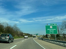
Interstate 83 has its northern terminus at Interstate 81 exit 70 in Dauphin County just north of Harrisburg, the capital of Pennsylvania. Its first exit, 50, is at U.S. Route 22 (Jonestown Road) in Lower Paxton Township. (4-10-2026)

Just ahead, the ramps to southbound I-83 from each direction of I-81 meet. (4-10-2026)

For its first few miles, I-81 is concurrent with U.S. Route 322, which joins it from I-81 south. It also constitutes the east side of Harrisburg's Capital Beltway, which also includes the portion of I-81 passing just north of Harrisburg. (4-10-2026)

Exit 50 is on the other side of the Elmerton Avenue overpass. (4-10-2026)

US 22 crosses I-83 as southbound I-83 receives a cloverleaf onramp from US 22 east. (4-10-2026)

The Interstate then picks up traffic from US 22 west. (4-10-2026)

I-83 and US 322 reassurance directly follows exit 50. (4-10-2026)

In ¾ mile, I-83 meets Union Deposit Road at exit 48, leading to the UMPC Community Osteopathic hospital. US 322 parts with I-83 in 2 miles going toward Hershey, and a left exit onto southbound Interstate 283 toward Harrisburg International Airport is 2½ miles away. (4-10-2026)

A variable message sign hangs over the highway between exits. (4-10-2026)

A mile and a half after exit 48, US 322 diverts east onto Eisenhower Boulevard at exit 47. Half a mile afterward comes the movement onto southbound I-283, exit 46A, leading toward the airport as well as the Pennsylvania Turnpike (Interstate 76). These two exits form part of the Eisenhower Interchange. (4-10-2026)

The exit 48 gore sign. (4-10-2026)

The exit 48 gore sign. (4-10-2026)

Shields for each highway at the interchange are painted onto their respective lanes. (4-10-2026)

Exit 47 can also be used to reach Derry Street and Paxton Street. (4-10-2026)

The movement from I-83 south to US 322 east involves taking Eisenhower Boulevard due south past Derry Street, which it meets at a separate interchange, and under I-83, then taking a cloverleaf ramp onto US 322 east. This ramp ends at the same point where northbound I-83 turns back north. (4-10-2026)

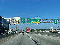
Now reaching the Eisenhower Interchange, which marks the southeast corner of the Capital Beltway, I-83 turns due west, while I-283 goes south toward the borough of Highspire and the Turnpike and airport. A state route, PA 283, links I-283 and Harrisburg's East Shore with the city of Lancaster to the southeast. At this point, I-83 picks up a southbound control city of York. (7-15-2024)

Separate ramps to I-283 south (left) and I-83 south (right) part here. Northbound I-83 passes by along a flyover ramp to the left. (7-15-2024)

Exit 45, intersecting Paxton Street and Bass Pro Drive, is ⅜ of a mile away. Pennsylvania is one of a handful of states that still use eighth-mileages on their highway signs. (7-15-2024)

At right, I-83 collects traffic from US 322 west. (7-15-2024)
Exit 45 is ahead at right. Bass Pro Drive is named for one of the area Harrisburg Mall's anchor stores. (7-15-2024)

The mall sits on the opposite side of the interchange from the exit. (7-15-2024)

Paxton Street then passes over the highway. (7-15-2024)

Traffic from Paxton/Bass Pro enters I-83 south at right. (7-15-2024)

The speed limit along this stretch of the highway is 55 miles per hour. (7-15-2024)

Crossing next is 29th Street. (7-15-2024)
Downtown Harrisburg can be accessed rom any of the next three exit ramps. (7-15-2024)

Exit 44B to 17th Street is half a mile away. (7-15-2024)

At exit 44B, there is advance signage for exit 43 for the state capitol building and 2nd Street. (7-15-2024)

The exit 44B gore sign. (7-15-2024)

Exit 44A, intersecting Pennsylvania Route 230 (13th Street), is ¼ mile away. Meanwhile, exit 43 serves Harrisburg's Amtrak and bus terminal. (7-15-2024)

Between exits sits I-83 reassurance. (7-15-2024)

The Interstate reaches exit 44A and is ¼ mile from exit 43. (7-15-2024)

The exit 44A gore sign. (7-15-2024)

I-83 crosses multiple railroad tracks, then begins its crossing of the Susquehanna River (John Harris Memorial Bridge) prior to exit 43. (7-15-2024)
Exit 43 lies ahead. This is I-83's closest access to downtown Harrisburg. (7-15-2024)

The exit 43 gore sign. The southbound ramp to 2nd Street crosses over the northbound ramp. (7-15-2024)

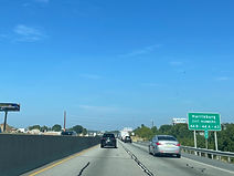
Now fully over the Susquehanna, advance signage appears for exit 41B for the borough of Lemoyne, and exit 41A, where I-83 leaves the Capital Beltway, which then becomes Pennsylvania Route 581. PA 581's control cities are Camp Hill and, via U.S. Route 15, Gettysburg. (7-15-2024)

A Capital Beltway logo sign is located along the bridge. (7-15-2024)

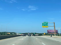
The Lemoyne exit is in ¼ mile. (7-15-2024)

Exit 41B is at the end of the bridge; it leads to 3rd Street and Bridge Street. Exit 41A is in half a mile, with I-83 being marked as leading to the Pennsylvania Turnpike. (7-15-2024)

Distances to the Turnpike and U.S. Route 30 in York along I-83 are displayed by a variable message sign at right. (7-15-2024)

The Interstate passes under 3rd Street prior to the 581 split. (7-15-2024)

I-83 now splits from the Capital Beltway to the right, then essentially makes a wide U-turn and heads south toward York and its southern terminus in Baltimore, Maryland. PA 581 goes about six miles west to its theoretical parent of I-81. (7-15-2024)