
The epzik8 Webpage
Interstate 83 south - Camp Hill to Maryland line

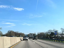
In Lower Allen Township, Cumberland County, Pennsylvania, Interstate 83 heads south away from Harrisburg's Capital Beltway, which becomes Pennsylvania Route 581 at the preceding interchange, exit 41. An exit along PA 581, 6C, to the right leads to the borough of Lemoyne via Lowther Street. (4-10-2026)

I-83's southbound control cities are currently York and Baltimore, Maryland, and it is heading toward an interchange with the Pennsylvania Turnpike (Interstate 76). Just ahead, I-83 intersects Carlisle Road, which leads to New Cumberland, at exit 40B. (4-10-2026)

This overhead sign points the way to exit 40B. (4-10-2026)
An I-83 reassurance shield follows exit 40B. (4-10-2026)

I-83's interchange with the Turnpike is exit 39B and is 1¼ mile away. The Turnpike's control cities are Philadelphia to the east and Pittsburgh to the west, the two largest cities in Pennsylvania. (4-10-2026)

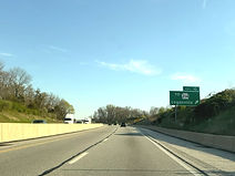
In the meantime, the Interstate is half a mile from meeting Limeklin Road at exit 40A. (4-10-2026)

Gas stations are available at both exit 39A and 40A. (4-10-2026)

Just before exit 40A, I-83 crosses Yellow Breeches Creek into Fairview Township, York County. I-83 will spend the remainder of its time in Pennsylvania in this county. (4-10-2026)
The exit 40A gore sign. (4-10-2026)

Exit 39A, which intersects Pennsylvania Route 114 (Lewisberry Road), is half a mile away, and ¼ mile past exit 39B. (4-10-2026)

I-83 uses this bridge to cross the Turnpike. (4-10-2026)

Exit 39B departs to the Turnpike straight ahead. (4-10-2026)

The Turnpike's meeting with I-83 is formally dubbed the Harrisburg West interchange, and is exit 242 of I-76. (4-10-2026)

An I-83 reassurance shield is placed at the end of the southbound onramp from the Turnpike. (4-10-2026)

The New Cumberland facility of the Defense Logistics Agency (DLA) as well as the Capital City Airport can be reached from exit 39A. (4-10-2026)

Exit 39A, a cloverleaf ramp, is on the other side of PA 114's crossing of I-83. (4-10-2026)

Exit 38, which serves the community of Reesers Summit, is ¾ mile away. The Interstate meanwhile has temporarily expanded to three lanes, prohibiting trucks from the left lane while encouraging them to use the right lane. (4-10-2026)

The cross street of exit 38 is Pleasant View Road, which crosses I-83 here. (4-10-2026)

Exit 38 is ahead on the right. (4-10-2026)

The exit 38 gore sign. (4-10-2026)

The right lane ends in 2,000 feet. (4-10-2026)

The next three exits are situated along a 4-mile stretch. (4-10-2026)

Park Road crosses the Interstate next. (4-10-2026)

The highway is ¾ mile from exit 36, which intersects Pennsylvania Route 262 (Fishing Creek Road). (4-10-2026)

The Interstate passes through a grove of trees before it reaches exit 36. (4-10-2026)

The next exit, 35, provides access to Gifford Pinchot State Park. (4-10-2026)

There is I-83 reassurance between exits. (4-10-2026)

A weigh station sits 1¼ miles from the blue sign at right. (4-10-2026)

Exit 35 intersects Pennsylvania Route 177 toward Lewisberry in half a mile. (4-10-2026)

Exit 35 is straight ahead on the right. (4-10-2026)
I-83 passes under PA 177 (Wyndamere Road) before it actually reaches the exit. (4-10-2026)

The exit 35 gore sign. (4-10-2026)

The weigh station immediately follows exit 35. (4-10-2026)

In ¾ mile, exit 33 intersects Pennsylvania Route 392 toward Yocumtown. (4-10-2026)

This overhead sign points the way to exit 33. (4-10-2026)

The exit 33 gore sign. (4-10-2026)

Exit 32 intersects Pennsylvania Route 382 toward Newberrytown in ¾ mile. (4-10-2026)

Exit 32 sits just ahead. (4-10-2026)

After exit 32, Strinestown and York are a respective 3 and 12 miles away. (4-10-2026)

The Interstate goes on under Sheep Bridge Road. (4-10-2026)

In 2 miles, exit 28 intersects Pennsylvania Route 297 (formerly PA 295) which leads toward Zions View and Strinestown. (4-10-2026)

Before the exit, I-83 crosses Conewago Creek into Conewago Township. (4-10-2026)

Conewago Creek is only acknowledged at the end of the bridge. (4-10-2026)

A Sheetz and a Rutter's compete against each other at this exit. (4-10-2026)

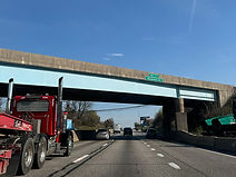
Exit 28 is just ahead on the right. PA 297 was renumbered from PA 295 in 2018 when Interstate 295 was extended from New Jersey into Bristol Township in Bucks County. (4-10-2026)

This portion of PA 297 is part of the Susquehanna Trail, a portion of the former U.S. Route 111 whose corridor I-83 now runs along. (4-10-2026)

Emigsville and York are a respective 3 and 6 miles away from here. (4-10-2026)

The Interstate glides downhill before flattening out and crossing the Little Conewago Creek, then Pennsylvania Route 921 (Canal Road). (4-10-2026)
In 2 miles, I-83 meets Pennsylvania Route 238 at exit 24, bearing a control city of Emigsville. (4-10-2026)

The Interstate climbs uphill before it reaches exit 24. (4-10-2026)

The exit 24 gore sign. (4-10-2026)

Known as Church Road, PA 238 is a 5½-mile link between PA 74 in the Shiloh area northwest of York, and PA 181 just to the east of here in Manchester Township. (4-10-2026)

Exit 24 is immediately followed by I-83 reassurance. (4-10-2026)

Sinking Springs Lane then crosses the highway. (4-10-2026)

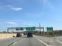
The distances to the three upcoming exits serving York city are posted to the right. (4-10-2026)
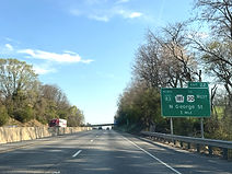
One mile away, exit 22 intersects Pennsylvania Route 181 (North George Street), leading toward westbound U.S. Route 30. This is also the north end of Interstate 83 Business. (4-10-2026)

The city of Gettysburg can be reached from exit 22 by way of westbound US 30, and Lancaster from exit 21 up ahead. (4-10-2026)
Half a mile after exit 22, exit 21 provides access to eastbound US 30 (Arsenal Road). (4-10-2026)
The exit 22 gore sign. (4-10-2026)

I-83 reassurance again sits between exits. (4-10-2026)

Exit 21 is ahead on the right. Northbound, this exit has ramps to both directions of US 30. (4-10-2026)

The exit 21 gore sign. (4-10-2026)

The highway curves wide left after exit 21. (4-10-2026)

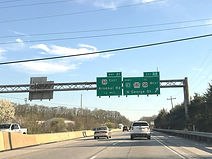
In one mile, I-83 will meet Pennsylvania Route 462 (Market Street) at exit 19. (4-10-2026)

Sherman Street passes overhead in the meantime. (4-10-2026)

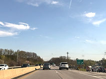
Food options at exit 19A are displayed to the right. (4-10-2026)

The highway enters a heavy merge area, a result of its congested nature and narrow shoulders through York city. (4-10-2026)

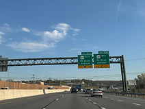
A shield at right indicates that exit 19B (PA 462 west) is just ahead. (4-10-2026)

Exit 19A follows soon thereafter. (4-10-2026)

At exit 18, I-83 intersects Pennsylvania Route 124 (Mt. Rose Avenue) ¾ mile away. (4-10-2026)

The distances to the remaining York exits are posted to the right. (4-10-2026)
Exits 18B and A each have their own exit lanes from I-83 south. (4-10-2026)

Exit 18A, a cloverleaf, is on the opposite side of PA 124's crossing of I-83. PA 124 itself runs 13 miles from York's eastern city limit to the community of Craley in Lower Windsor Township. (4-10-2026)

The Interstate curves widely to the left after exit 18. (4-10-2026)

I-83 reassurance is then posted on the right. (4-10-2026)

Between exits, I-83 leaves Spring Garden Township for York Township. (4-10-2026)

In one mile, at exit 16, I-83 intersects Pennsylvania Route 74 (Queen Street). (4-10-2026)

Some of the services at exit 16 are posted to the right. (4-10-2026)

After exit 16, I-83 meets the southern end of its business route at exit 15. Half a mile afterward, it intersects Pennsylvania Route 182 (Leader Heights Road) at exit 14. (4-10-2026)

The southbound offramp to northbound I-83 Business is on the other side of the Powder Mill Road overpass seen in the distance. This exit can be taken to the York Hospital. (4-10-2026)

Approaching exit 14, Baltimore becomes I-83's sole southbound control city. (4-10-2026)

This overhead sign points the way to exit 14. (4-10-2026)

PA 182 (Leader Heights Road), which crosses I-83 here, runs 7 miles along the southwest side of greater York, linking PA 462 in West York with PA 74. (4-10-2026)

As it picks up an onramp from PA 182, I-83 starts to go downhill. (4-10-2026)

In the distance, at the bottom of the hill, the Interstate curves to the left. (4-10-2026)

The borough of Glen Rock is 5 miles away, and Baltimore lies 47 miles away. (4-10-2026)

I-83 then curves right on approach to a bridge over Lake Redman, which separates the Interstate from the nearby borough of Jacobus, and enters Springfield Township. (4-10-2026)

The highway is now a mile from exit 10, which indirectly leads to Pennsylvania Route 214 and serves the borough of Loganville. (4-10-2026)
Exit 10 is situated at a hillcrest. (4-10-2026)

The road intersected at exit 10 is North Street (SR 3100). (4-10-2026)

Once past exit 10, I-83 starts going back downhill, soon crossing PA 214 (Dunkard Valley Road) itself. (4-10-2026)


The Glen Rock exit intersects Pennsylvania Route 216 (Seaks Run Road) and is 2 miles away. (4-10-2026)

The Interstate climbs uphill and passes under Ridge View Road in the meantime. (4-10-2026)

Exit 8 is just ahead on the right. PA 216 runs 26 miles from Pennsylvania Route 116 just east of Hanover to Pennsylvania Route 24 in the borough of Winterstown. (4-10-2026)

The exit 8 gore sign. (4-10-2026)

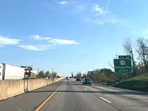
The highway climbs uphill away from exit 8, with I-83 reassurance, and soon makes its way into Shrewsbury Township. (4-10-2026)

The borough of Shrewsbury is 3 miles from here, and Baltimore 41. (4-10-2026)

Between exits, I-83 passes under Hain Road. (4-10-2026)

It then goes by the Markets at Shrewsbury, home to Amish farm stands and gift and antique shops. (4-10-2026)

Exit 4 is I-83's final exit in Pennsylvania. It intersects Pennsylvania Route 851 (Forrest Avenue) and serves Shrewsbury. (4-10-2026)

In the meantime, an AM radio frequency is posted on a sign to the right for drivers to tune to for travel information. (4-10-2026)

An unlikely commercial hub situated just above the state line, exit 4 contains numerous food options. (4-10-2026)

Plank Road passes overhead before the exit. (4-10-2026)

Just before the exit, I-83 crosses Mount Airy Road and nicks a corner of Hopewell Township. (4-10-2026)

Exit 4 is just ahead on the right. PA 851 runs 32 miles across five of the seven townships making up York County's southern tier: Codorus, Shrewsbury, Hopewell, Fawn and Peach Bottom. (4-10-2026)

The exit 4 gore sign. This exit was reconfigured from a simple diamond to a diverging diamond interchange (DDI), York County's first, in 2021. (4-10-2026)

I-83 climbs uphill as it receives an onramp from PA 851. (4-10-2026)

A partial interchange with Freeland Road just over the Maryland line is 3 miles away, and Baltimore 37. (4-10-2026)

The highway goes on over a tributary of the nearby Deer Creek, as well as Tolna Road. (4-10-2026)

The Freeland Road exit is southbound Maryland exit 37, and is 2 miles away. (4-10-2026)

Before leaving Pennsylvania, I-83 passes under Stewartstown Road. (4-10-2026)

The green sign on the right points the way to exit 37. (4-10-2026)

Ahead of the Freeland Road overpass, I-83 departs the Commonwealth of Pennsylvania and enters Maryland, finding itself in the Parkton area of far-northern Baltimore County. (4-10-2026)