
The epzik8 Webpage
Interstate 83 north - Jones Falls Expressway

At the intersection of President and Fayette streets in Baltimore, Maryland, Interstate 83 kicks off its 85-mile journey to the northern area of Harrisburg, Pennsylvania. (7-28-2024)
At the time of these photos, the northbound left lane was closed for several miles and the bridge over North Avenue was being worked on. (7-28-2024)

This first section of I-83 is known as the Jones Falls Expressway (JFX), after the waterway it follows. (7-28-2024)

Finding itself on a viaduct, the highway curves slightly left. (7-28-2024)

Now curving wide right, the Interstate passes by the Mercy Medical Center and Bunting Garage. In the distance, U.S. Route 40 passes overhead on the Orleans Street Bridge. (7-28-2024)

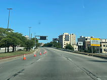
I-83 receives an onramp from Gay Street at right and nears an exit at Chase Street. (7-28-2024)

A faded I-83 shield then sits at right. (7-28-2024)

The ramp to Chase Street (exit 3) sits ahead, beside the Central Booking facility, and the North Avenue exit is just over a mile away. (7-28-2024)

The JFX now proceeds slightly downhill. (7-28-2024)

An onramp from Madison Street enters at right as Chase Street passes over the highway. (7-28-2024)

Crossing next is Biddle Street. (7-28-2024)

More I-83 reassurance sits ahead of the Preston Street overpass. (7-28-2024)

Interstate traffic is now faced with a sharp leftward curve. (7-28-2024)

After the curve, Calvert Street (northbound Maryland Route 2) passes overhead. (7-28-2024)

Exit 6, for North Avenue (U.S. Route 1, also part of a US 40 truck route) is half a mile away. This also includes, on the northbound side, ramps (exit 7) to and from 28th Street eastbound and Druid Park Lake Drive westbound. Due to I-83's cancellation through Fells Point and Canton and out to I-95, its exit numbers in Maryland are a few miles off from the mile markers they are located along. (7-28-2024)

In the meantime, Charles Street, the line between east and west Baltimore, crosses I-83. (7-28-2024)

The Baltimore Zoo is off exit 7, while truck traffic to east Baltimore is to use exit 6. Meanwhile, crossing overhead now is Maryland Avenue. (7-28-2024)

Baltimore's Light RailLink passes over here. (7-28-2024)

This is followed by Howard Street's arch-themed bridge, seen here. (7-28-2024)

The roadway leading to exits 6 and 7 leaves I-83 proper at right. (7-28-2024)

As the JFX passes exit 6, there is a notation of the Hampden area being off exit 8. (7-28-2024)

The Interstate proceeds to cross North Avenue in the vicinity of Baltimore's Penn Station. Photo taken 07-28-2024.

Traffic coming from North Avenue and Mount Royal Avenue joins northbound I-83 at right. Photo taken 07-28-2024.

Signage for each leg of exit 7 is seen at right. Photo taken 07-28-2024.

Exits 7A and B split up ahead. Around here, Falls Road begins to parallel I-83 to the right. Photo taken 07-28-2024.

Falls Road (Maryland Route 25) is intersected at exit 8 half a mile ahead. Photo taken 07-28-2024.

The flyovers between I-83 north and Druid Hill, and between 28th Street west and I-83 south, are seen here. Access to I-83 south from Druid Hill is via Mount Royal Avenue. Photo taken 07-28-2024.

The Interstate goes on to cross 29th Street. Photo taken 07-28-2024.

The right lane of the highway is now reserved for Falls Road traffic. Photo taken 07-28-2024.

Exit 8 is up ahead, and the distances to the next two exits (Cold Spring Lane and Northern Parkway) are displayed at right. Photo taken 07-28-2024.

The exit 8 gore sign. Photo taken 07-28-2024.

Here, the highway passes over the ramp from MD 25 south to I-83 south. Photo taken 07-28-2024.

The Interstate curves slightly left, then back right. Photo taken 07-28-2024.

Another posted 50 MPH speed limit marks the beginning of a viaduct. Photo taken 07-28-2024.

The highway proceeds wide right. Photo taken 07-28-2024.

The Cold Spring Lane and Northern Parkway exits are one and two miles away. Photo taken 07-28-2024.

Seen at right is what was once known as the Pepsi Sign, now displaying the company name Plant 83. Photo taken 07-28-2024.

Components of Loyola University are off the forthcoming exit 9. Photo taken 07-28-2024.

Another wide curve to the right is ahead. Near this point is Television Hill, where three of Baltimore's four broadcast news stations are situated. Photo taken 07-28-2024.

Exit 9A for eastbound Cold Spring Lane is ¼ mile away. Photo taken 07-28-2024.

Exit 9B for westbound Cold Spring Lane is ¼ mile after that. Photo taken 07-28-2024.

Cold Spring Lane passes over the JFX here; a guardrail separates the northbound carriageway from exit 9B at right. Photo taken 07-28-2024.

Northern Parkway is now a mile ahead; there is then a three-mile gap before the next exit, at Ruxton Road. Photo taken 07-28-2024.

Still within exit 9, the Interstate has a bridge over the Jones Falls. Photo taken 07-28-2024.

The JFX curves left prior to advance signage for Northern Parkway (exits 10A-B). Photo taken 07-28-2024.

I-83 reassurance is given between exits. Photo taken 07-28-2024.

Northern Parkway traffic is directed to the right lane. Photo taken 07-28-2024.

Exit 10A for eastbound Northern Parkway sits ahead. Photo taken 07-28-2024.

The northbound iteration of exit 10A has a slight S-curve along its course. Photo taken 07-28-2024.

Northern Parkway, a 17-mile controlled-access road running the width of north Baltimore between Liberty Heights Avenue (MD 26) and Belair Road (US 1), passes over the JFX here. Photo taken 07-28-2024.

Exit 10B to westbound Northern Parkway is at right. Ahead, a flyover ramp accessible from both directions of Northern Parkway leads to I-83 south. Photo taken 07-28-2024.

A closer look at the southbound flyover. Just to the west of here sit the Sinai hospital and the Pimlico race course, home of the Preakness every May. Photo taken 07-28-2024.

Incoming traffic from Northern Parkway enters at right. Photo taken 07-28-2024.

This overpass carries Kelly Avenue over the JFX. Kelly Avenue passes through the Mount Washington area. Photo taken 07-28-2024.

Just further along, a small cutout I-83 reassurance shield is affixed to a light pole. Photo taken 07-28-2024.

Preparing to exit Baltimore city limits, the Interstate crosses over the Light RailLink. Photo taken 07-28-2024.

I-83 then enters Baltimore County, and the State Highway Administration takes responsibility of it from the Baltimore City Department of Transportation. Photo taken 07-28-2024.

The speed limit goes up to 55 miles per hour past the city/county line. Photo taken 07-28-2024.

The temporary fourth lane at right ends in ¼ mile. Photo taken 07-28-2024.

The lane ends after the highway curves sharp right. Photo taken 07-28-2024.

The JFX now goes gradually downhill. Photo taken 07-28-2024.

At the bottom of the hill, it crosses Pimlico Road. Photo taken 07-28-2024.

Exit 12, intersecting Ruxton Road and leading to Old Court Road (MD 133), is a mile away, while Interstate 695 is two miles away. Photo taken 07-28-2024.

There is additional I-83 reassurance in the meantime. Photo taken 07-28-2024.

Subsequently, there is another wide curve to the right. Photo taken 07-28-2024.

A sign in the median directs interests to Ruxton Road to the right lane. Photo taken 07-28-2024.

The highway crosses over Falls Road just prior to the exit. Photo taken 07-28-2024.

Exit 12 lies ahead, while I-695 is a mile away. Photo taken 07-28-2024.

A look at the exit 12 gore. Photo taken 07-28-2024.

At the interchange ahead, I-695 (Baltimore Beltway) goes west (outer loop) to Pikesville, and east (inner loop) to Towson. Northbound I-83 joins the inner loop of I-695 for one exit with a control city of York, Pennsylvania. Meanwhile, there is access from the JFX straight ahead to MD 25 from the left northbound lane. Photo taken 07-28-2024.

A gradual curve to the left precedes the Beltway interchange. Photo taken 07-28-2024.

The split to each direction of the Beltway sits ahead. Photo taken 07-28-2024.

The gore sign at left points traffic to each direction of I-695 as well as I-83 north. Photo taken 07-28-2024.
