
The epzik8 Webpage
Interstate 75 south - Port Charlotte to Naples

Interstate 75 south is pulling away from exit 170 at Charlotte County Route 769 (Kings Highway) east of Port Charlotte. Photo taken 10-03-2024.

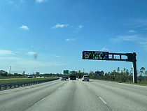
An overhead variable message sign soon afterward displays the distance and time to exit 161 (CR 768). Photo taken 10-03-2024.

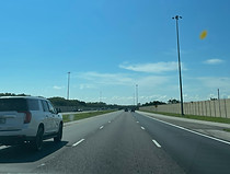
The Interstate soon passes under Rampart Boulevard. Photo taken 10-03-2024.

Exit 167 up ahead leads to the Harbor Heights section of Port Charlotte. Photo taken 10-03-2024.

Exit 167 intersects Harborview Road (CR 776). Photo taken 10-03-2024.

Punta Gorda, the seat of Charlotte County, is served by the next three exits. Photo taken 10-03-2024.

An AM radio frequency is posted at right after Harborview for traveler information. Photo taken 10-03-2024.

The southbound carriageway receives traffic from Harborview at right. Photo taken 10-03-2024.

Exit 164, intersecting U.S. Route 17 (Duncan Road) toward Punta Gorda and Arcadia in DeSoto County, is two miles away. Photo taken 10-03-2024.

The Interstate passes over a small tributary of the Peace River. Photo taken 10-03-2024.

It then begins crossing the Peace itself, with 70 MPH speed limit. Photo taken 10-03-2024.

At right, off-photo, sits downtown Punta Gorda; beyond that lies the Peace's mouth at the Gulf of Mexico. Photo taken 10-03-2024.

The bridge then reaches its end. Photo taken 10-03-2024.

A Vietnam Memorial Wall, Military Heritage Museum and the Peace River Wildlife Center are off exit 164. Photo taken 10-03-2024.

Exit 164 is here. US 17, whose north end is at Winchester, Virginia, has its southern terminus a stone's throw away in downtown Punta Gorda at US 41. Photo taken 10-03-2024.

Traffic from US 17 enters at right. Photo taken 10-03-2024.

A sign at right has a truck parking counter for an approaching weigh station. Photo taken 10-03-2024.

Then, Henry Street passes overhead. Photo taken 10-03-2024.

A subsequent VMS at Airport Road displays the distance and time to the forthcoming exit at SR 78. Photo taken 10-03-2024.

Exit 161 at James Loop Road (CR 768) toward Punta Gorda and its airport is a mile away. Photo taken 10-03-2024.

Some of the gas and food options at exit 161 are displayed to the right. Photo taken 10-03-2024.

A leftward curve leads into exit 161. Photo taken 10-03-2024.

The exit 161 gore. Photo taken 10-03-2024.

I-75 then crosses James Loop. Photo taken 10-03-2024.

The Interstate straightens out and soon reaches the weigh station entrance. Photo taken 10-03-2024.

Exit 158 at Tuckers Grade (CR 763) toward North Fort Myers and Cape Coral is 1¼ miles away. Photo taken 10-03-2024.

Tropical Gulf Acres and the Babcock-Webb WMA are off this exit. Photo taken 10-03-2024.

The highway curves to the right and then reaches exit 158. Photo taken 10-03-2024.

I-75 crosses Tuckers Grade, which proceeds due east into Babcock-Webb. Photo taken 10-03-2024.

Fort Myers and Naples are now a respective 21 and 56 miles away. Photo taken 10-03-2024.

The Interstate curves slight left again. Photo taken 10-03-2024.

Straightening out, the highway then passes under Oil Well Road. Photo taken 10-03-2024.

Leaving Babcock-Webb behind, the Interstate continues for a few miles with an alternating tree and lake-lined median. Photo taken 10-03-2024.

One of said lakes stretches the entire right-of-way of I-75, and the highway crosses it here. Photo taken 10-03-2024.

There is subsequently a gradual curve to the right. Photo taken 10-03-2024.

An interchange with SR 80 is a few minutes' drive south of this VMS. Photo taken 10-03-2024.

The impending exit 143 is the exit of Babcock Ranch. It is also around this point where I-75 departs Charlotte County for Lee County. Photo taken 10-03-2024.

Exit 143 intersects Florida State Road 78 (Bayshore Road/Pine Island Road) toward North Fort Myers and Cape Coral in half a mile. SR 78 forms part of the main roadway alongside the north shore of Lake Okeechobee some miles to the east. Photo taken 10-03-2024.

I-75 reaches exit 143 and prepares to cross SR 78. Photo taken 10-03-2024.

The next four exits all serve Fort Myers, the largest city in Southwest Florida and seat of Lee County. Photo taken 10-03-2024.

Exit 141, 1¾ miles away, intersects Florida State Road 80 (Palm Beach Boulevard) running between Fort Myers and LaBelle, in Hendry County. Photo taken 10-03-2024.

The Caloosa Sound Convention Center and Amphitheater is off this exit. Photo taken 10-03-2024.

Before the exit, the highway crosses Popash Creek. Photo taken 10-03-2024.

Then, it has a crossing of the tidal Caloosahatchee River, where the Popash has its mouth. Photo taken 10-03-2024.

The midpoint of the Caloosahatchee bridge. Photo taken 10-03-2024.

Exit 141 has its own lane off the southbound carriageway. SR 80 also runs through the south side of Alva, the hometown of NASCAR driver Ross Chastain and his family's multi-generational watermelon farming enterprise. The Caloosahatchee is the facility separating SR 78 and SR 80 in the Alva area. Photo taken 10-03-2024.

The exit 141 gore sign. Photo taken 10-03-2024.

A dense cluster of palms sits beside I-75's crossing of SR 80. Photo taken 10-03-2024.

I-75 then pushes toward its next interchange, exit 139 at Luckett Road (CR 810). Photo taken 10-03-2024.

Between exits, I-75 passes under Tice Street. Photo taken 10-03-2024.

The services available at exit 139 are posted at right. Photo taken 10-03-2024.

Exit 139 lies ahead. Luckett Road serves little purpose other than to connect the area's Castlebar Court and Cypress resort. Photo taken 10-03-2024.

Exit 138 is 1¼ miles away and meets State Road 82, which leads due east to Immokalee in inland Collier County. Photo taken 10-03-2024.

Kaiser University is off exit 138. Photo taken 10-03-2024.

I-75 soon reaches and passes over SR 82. Immokalee, where SR 82 has its eastern terminus at State Road 29, is a fruit-growing town with a Hispanic majority, and is a few miles off from forming the northwest corner of the Everglades. Photo taken 10-03-2024.

The Interstate proceeds to pick up traffic from SR 82 at right. Photo taken 10-03-2024.
I-75 will meet Lee County Road 876 at exit 131 in 6 miles. Photo taken 10-03-2024.

In the meantime, I-75 will soon come across Florida State Road 884 (Colonial Boulevard) at exit 136, from which one can access either Fort Myers or Lehigh Acres. I-75's posed control city is now Naples. Photo taken 10-03-2024.

The Calusa Nature Center, Hodges University, and Edison Mall are off the upcoming exit. Photo taken 10-03-2024.

Final mainline advance signage for SR 884 is posted here. Photo taken 10-03-2024.

The exit 136 gore sign. Exit 136 is a diverging diamond interchange (DDI). Photo taken 10-03-2024.

After exit 136, the Interstate crosses the Six Mile Cypress Slough. Photo taken 10-03-2024.

A truck parking space counter for the forthcoming rest area is at right. Photo taken 10-03-2024.

The rest area is 2½ miles away, at exit 131. Photo taken 10-03-2024.

Trucks are prohibited from the left lane for the next 25 miles. Photo taken 10-03-2024.

Exit 131 at Daniels Parkway (SR 836) toward Cape Coral, the home of the National Hurricane Center, is 1¼ miles ahead. Photo taken 10-03-2024.

Exit 131 is the site of JetBlue Park (the spring training home of the Boston Red Sox) and the Lee Health Sports Complex (Minnesota Twins). Photo taken 10-03-2024.

Lodging options at exit 131 are posted at right. Photo taken 10-03-2024.

Exit 131 lies ahead. The rest area is located off Daniels Parkway adjacent to the onramp to I-75 north, allowing through traffic on Daniels to access it. Photo taken 10-03-2024.

Next comes exit 128 at Alico Road (CR 840) toward San Carlos Park and the Southwest Florida International Airport. Photo taken 10-03-2024.

Hertz Arena, the home of minor league hockey team the Florida Everblades, is off exit 128. Photo taken 10-03-2024.

Also reachable from this exit is the Florida Gulf Coast University. Photo taken 10-03-2024.

Final mainline signage for exit 128 is here. The ramps to and from Alico are along a collector-distributor roadway. Photo taken 10-03-2024.

The exit 128 gore sign. Photo taken 10-03-2024.

The ramp to Southwest Florida Int'l (RSW), which is unnumbered and not considered part of exit 128, is in the distance at right. Photo taken 10-03-2024.

The entrance road to RSW then passes over I-75. Photo taken 10-03-2024.

Exit 128 proper to Alico follows. Photo taken 10-03-2024.

The Interstate crosses over Alico Road here. Photo taken 10-03-2024.

It reaches the end of the exit, and curves to the left up ahead. Photo taken 10-03-2024.

The highway straightens out and picks up a sound barrier to its west. Photo taken 10-03-2024.

Exit 123 intersects CR 850 (Corkscrew Road/Miromar Outlets Blvd) toward Estero. Photo taken 10-03-2024.

This exit leads to the Koreshan State Historic Site. Photo taken 10-03-2024.

Estero Parkway then passes over the Interstate. Photo taken 10-03-2024.

At left, a lake separates Hertz Arena from the outlets. Photo taken 10-03-2024.

Exit 123, with no gore sign, is seen on the right. Photo taken 10-03-2024.
I-75 crosses CR 850, then receives the onramp from it. Photo taken 10-03-2024.

The next crossing is of a canal surrounding the Corkscrew Woodlands. Photo taken 10-03-2024.

This portion of I-75 is a hurricane evacuation route. Photo taken 10-03-2024.

The Interstate now enters Bonita Springs. Photo taken 10-03-2024.

Following the city limits, the highway curves to the left. Photo taken 10-03-2024.

In 1¼ miles, I-75 will reach exit 116 at Bonita Beach Road (CR 865). Photo taken 10-03-2024.

Lovers Key State Park between the Gulf and the Estero Bay is off this exit. Photo taken 10-03-2024.

Terry Street proceeds to pass overhead. Photo taken 10-03-2024.

Exit 116 sits ahead at right. Photo taken 10-03-2024.

I-75 crosses the Imperial River before reaching exit 116. Photo taken 10-03-2024.

After crossing Bonita Beach, an onramp enters in the distance. Photo taken 10-03-2024.

An I-75 reassurance shield follows exit 116. Photo taken 10-03-2024.

Downtown Naples is 11 miles from this point. Photo taken 10-03-2024.

It is here that I-75 enters Collier County. Photo taken 10-03-2024.

This VMS then displays the distance and time to Collier CR 886. Photo taken 10-03-2024.

Exit 111 in 1¼ mile intersects Immokalee Road toward North Naples and Delnor-Wiggin State Park. Photo taken 10-03-2024.

Corkscrew Sanctuary and the planned community of Ave Maria are both off exit 111. Photo taken 10-03-2024.

Exit 111 is ahead at right. Photo taken 10-03-2024.

Beforehand, I-75 crosses a canal surrounding the exit. Photo taken 10-03-2024.

The exit 111 gore sign. Photo taken 10-03-2024.

I-75 proceeds over Immokalee Road. Photo taken 10-03-2024.

Another I-75 marker appears afterward. Photo taken 10-03-2024.

Distances to Fort Lauderdale (via I-595) and Miami (via SR 826 and I-95) now begin to appear on southbound mileage signs. Photo taken 10-03-2024.

Soon, the Interstate crosses Vanderbilt Beach Road. Photo taken 10-03-2024.

The highway continues due south, with fresh asphalt. Photo taken 10-03-2024.

Exit 107, ahead on the right, intersects Pine Ridge Road toward Naples and Golden Gate. Photo taken 10-03-2024.

The exit 107 gore sign. Photo taken 10-03-2024.

I-75 passes over Pine Ridge here. Photo taken 10-03-2024.

Exit 105, 2 miles ahead, intersects Golden Gate Parkway (CR 886). Photo taken 10-03-2024.

Exit 105 can be used to the Naples Botanical Garden. Photo taken 10-03-2024.

Numerous trees line the highway approaching exit 105. Photo taken 10-03-2024.

At exit 105, I-75's southbound control city becomes Miami. Photo taken 10-03-2024.

The exit 105 gore sign. Photo taken 10-03-2024.

Within this interchange, I-75's orientation shifts from south to east. Photo taken 10-03-2024.

I-75 proceeds to cross the Golden Gate Canal. Photo taken 10-03-2024.

The speed limit remains 70 for the time being. Photo taken 10-03-2024.

Exit 101 leads to East Naples and Collier-Seminole State Park. Photo taken 10-03-2024.

No gas is available for 50 miles after exit 101. Photo taken 10-03-2024.

Exit 101 intersects CR 951, leading to SR 84 toward Naples and Marco Island. This is the final exit before I-75's journey through the Everglades along Alligator Alley. Photo taken 10-03-2024.

FSW State College and the Rookery Bay Reserve are off this exit. Photo taken 10-03-2024.

The distance to the SR 29 interchange is displayed overhead. Photo taken 10-03-2024.

Alligator Alley's toll plaza sits two miles from here. Photo taken 10-03-2024.

Exit 101 then leaves the highway. Photo taken 10-03-2024.