
The epzik8 Webpage
Interstate 70 east - Frederick to Baltimore

In Frederick, Maryland, eastbound Interstate 70 approaches exit 53 with Interstate 270, which heads toward Washington, DC by way of parts of Interstate 495 and Maryland Route 355. Photo taken 08-28-2025.

The eastbound component of exit 53 is seen at right. For a couple of decades, prior to federal highway guideline changes discouraging letter-suffixed route designations, I-270 was I-70S, while the Frederick-to-Baltimore corridor was I-70N. Under this arrangement, Maryland's original I-270 was what is now the I-270 Spur, a western shortcut between I-270 and I-495 roughly cutting between North Bethesda and Potomac, in Montgomery County. Photo taken 08-28-2025.

As it receives traffic from eastbound U.S. Route 40 on the left, I-70 passes over each carriageway of I-270. I-70's local counterpart for the vast majority of its length (as far west as Empire, Colorado), US 40 will overlap with the Interstate for about the next 29 miles. Photo taken 08-28-2025.

Exits for Frederick, which fall within a two-mile span, are displayed overhead. Photo taken 08-28-2025.

At the onramp from I-270 north to I-70 east, New Design Road passes overhead along a wide bridge. Photo taken 08-28-2025.

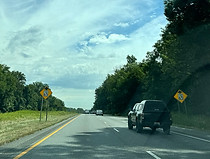
Up ahead, exit 54 leads to Maryland Route 85 (East Street), running between downtown Frederick and Buckeystown. Photo taken 08-28-2025.

Nymeo Field at Harry Grove Stadium, home of minor league baseball's Frederick Keys, can be reached from exit 54 along with MD 355 (Market Street) and MARC's Monocacy station along the Frederick spur of the Brunswick Line. Photo taken 08-28-2025.

Exit 54 is a single-point urban interchange (SPUI) where there are separate lanes to each direction of MD 85. Photo taken 08-28-2025.

The exit 54 gore sign. Photo taken 08-28-2025.

Exit 55 sits at South Street and Monocacy Boulevard up ahead. Photo taken 08-28-2025.

I-70 crosses South Street before the eastbound exit ramp. Photo taken 08-28-2025.

At exit 55, there is ¾ mile advance signage for exit 56 with Maryland Route 144 (Patrick Street). Photo taken 08-28-2025.

The "B" barrack of the Maryland State Police in Frederick can be reached from exit 56, along with the Frederick County Sheriff's Office and a Motor Vehicle Administration (MVA) facility. Photo taken 08-28-2025.

Between exits sits a I-70/US 40 reassurance shield assembly. Photo taken 08-28-2025.

The Frederick County Fairgrounds, Frederick Airport and a park and ride are off this exit. Photo taken 08-28-2025.

MD 144, internally designated MD 144FA along this segment of the route, passes over I-70 at this time. Photo taken 08-28-2025.

Food at exit 56 includes a location of the Frederick-based Roy Rogers. Photo taken 08-28-2025.

This overhead sign points the way to Patrick Street. Photo taken 08-28-2025.

A corresponding onramp from Patrick Street reaches eastbound I-70 soon afterward. Photo taken 08-28-2025.

The I-70/US 40 shield assembly on the light pole ahead marks the highway's departure from the Frederick hub. Photo taken 08-28-2025.

The Interstate goes on over the scenic Monocacy River. Photo taken 08-28-2025.

It then passes under Linganore Road beside a median crossover. Photo taken 08-28-2025.

The next crossing is of Spring Ridge Parkway, the main street of the Spring Ridge development north of Bartonsville. Photo taken 08-28-2025.

Exit 59 again intersects MD 144, now Old National Pike, with control cities of Linganore and Ijamsville in one mile. Photo taken 08-28-2025.

In the meantime, Quinn Road passes overhead. Photo taken 08-28-2025.

Exit 59 is on the right. Photo taken 08-28-2025.

I-70 crosses MD 144 here. Photo taken 08-28-2025.

The Interstate aligns itself nearly due east past exit 59. Photo taken 08-28-2025.

Maryland Route 75 is intersected at an interchange 2 miles away, and Baltimore is 39 miles away. Photo taken 08-28-2025.

Between exits, I-70 passes under Mussetter Road. Photo taken 08-28-2025.

The historic section of New Market can be reached from exit 62 along with Adventure Park USA. Photo taken 08-28-2025.

Exit 62, in one mile, meets MD 75 which runs between Libertytown and Hyattstown. Photo taken 08-28-2025.

The area of Monrovia can also be reached from exit 62 by way of MD 75 south. Photo taken 08-28-2025.

A park and ride is also at exit 62. Photo taken 08-28-2025.

Exit 62 is ahead in the distance. Photo taken 08-28-2025.

The exit 62 gore. Photo taken 08-28-2025.

A weigh station is located a mile away. Photo taken 08-28-2025.

The weigh station functions as truck parking when it is closed. Photo taken 08-28-2025.

The weigh stations entrance is to the right. Photo taken 08-28-2025.

There is then more I-70/US 40 reassurance. Photo taken 08-28-2025.

The current speed limit is 70 miles per hour. Photo taken 08-28-2025.

MD 27 and Baltimore are a respective 4 and 35 miles east of this sign. Photo taken 08-28-2025.

A series of winding curves are located ahead. Photo taken 08-28-2025.

Before the first curve, Bartholows Road crosses I-70 via this tall overpass. Photo taken 08-28-2025.

The highway then curves gradually left. Photo taken 08-28-2025.

A truck rest area is a mile away. No cars are allowed and there are no proper restrooms. Photo taken 08-28-2025.

Meanwhile, the historic areas of Mount Airy and Westminster can be reached from exit 68 just ahead. Photo taken 08-28-2025.

The Interstate soon winds its way leftward once again. Photo taken 08-28-2025.

It climbs uphill, then crosses Bill Moxley Road. Photo taken 08-28-2025.

The highway then goes over an old railroad grade. Photo taken 08-28-2025.

The truck rest area entrance is at right. Photo taken 08-28-2025.

Some of the services available at exit 68 are displayed to the right. Photo taken 08-28-2025.

Exit 68 with Maryland Route 27, toward Damascus and Mount Airy, is a mile away. Photo taken 08-28-2025.

The highway S-curves and has a slight dip before the exit. Photo taken 08-28-2025.

Westminster, the seat of Carroll County, is reachable from exit 68, along with a park and ride. Photo taken 08-28-2025.

Exit 68 is ahead at the top of a hillcrest. Photo taken 08-28-2025.

The exit 68 gore sign. Photo taken 08-28-2025.

Within exit 68, I-70 enters Carroll County for about a mile and a half. Carroll County's highway network otherwise consists entirely of state routes. Photo taken 08-28-2025.

I-70 makes its passage of MD 27 here. Photo taken 08-28-2025.

The Interstate momentarily becomes straight and flat just beyond exit 68. Photo taken 08-28-2025.

There is a sharp curve to the right up ahead with a recommended speed of 65 miles per hour. Photo taken 08-28-2025.

The next exit, at Maryland Route 94, is 5 miles away. Photo taken 08-28-2025.

Within the curve, the highway's median is rather distinctly landscaped with shrubs and a tree. Photo taken 08-28-2025.

In the blink of an eye, I-70 leaves Carroll County for Howard County. Photo taken 08-28-2025.

The median then widens and again fills with shrubs. Photo taken 08-28-2025.

The Interstate proceeds under West Watersville Road. Photo taken 08-28-2025.

At a small hillcrest, attractions accessible from the forthcoming exit 73 are displayed on the right. Photo taken 08-28-2025.

One-mile advance signage for exit 73 with MD 94, toward Woodbine and Lisbon, is attached to the Watersville Road overpass. Photo taken 08-28-2025.

Another park and ride is available at exit 73. Photo taken 08-28-2025.

This ground-level sign points the way to exit 73. Photo taken 08-28-2025.

The exit 73 gore sign. Photo taken 08-28-2025.

Woodbine Road uses this bridge to cross I-70. Photo taken 08-28-2025.

After the exit, the Interstate makes its way past a meadow. Photo taken 08-28-2025.

An interchange with Maryland Route 97 is 2 miles away, while Baltimore lies 25 miles ahead. Photo taken 08-28-2025.

I-70 next passes under Morgan Station Road. Photo taken 08-28-2025.

Exit 76 with MD 97, with control cities of Westminster and the suburban Montgomery County community of Olney, is a mile away. Photo taken 08-28-2025.

The communities of Cooksville and Glenwood can be reached from this exit. Photo taken 08-28-2025.

No exit sign precedes the eastbound offramp for exit 76. Photo taken 08-28-2025.

Situated just below this overpass, MD 97 runs 55 miles from Silver Spring in Montgomery County just north of Washington, DC city limits, to the Pennsylvania line just north of the hamlet of Silver Run in Carroll County, where it continues on to Gettysburg. Photo taken 08-28-2025.

After exit 76 comes more I-70/US 40 reassurance. Photo taken 08-28-2025.

An interchange with Maryland Route 32 is 2½ miles away, and Baltimore is now 22 miles away. Photo taken 08-28-2025.

A variable message sign hangs over the eastbound lanes between exits. Photo taken 08-28-2025.

At left, a truck weigh station sits along the westbound carriageway. Photo taken 08-28-2025.

MD 32 is intersected a mile away at exit 80, and has control cities of Sykesville and Clarksville. Photo taken 08-28-2025.

West Friendship is off this exit along with the Howard County Fairgrounds. Photo taken 08-28-2025.

A park and ride is also located at exit 80. Photo taken 08-28-2025.

Exit 80 is ahead on the right. Photo taken 08-28-2025.

At exit 80, the Interstate curves left with a slight descent. Photo taken 08-28-2025.

Exit 80 is set to be rebuilt in the future with the project to expand MD 32 into a freeway between Maryland Route 108 in Clarksville and I-70, which has now reached Burntwoods Road in Glenelg. Photo taken 08-28-2025.

Landmarks at the forthcoming exit 82 include Ellicott City's Turf Valley golf resort. Photo taken 08-28-2025.

US 40 is now shown on reassurance below I-70 for the final time. Photo taken 08-28-2025.

Ellicott City, the seat of Howard County, is served by the next two exits. Photo taken 08-28-2025.

Exit 82, where US 40 departs I-70 as Baltimore National Pike, is a mile away. Photo taken 08-28-2025.

The highway passes under Sand Hill Road in the meantime. Photo taken 08-28-2025.

The McKeldin Area of Patapsco Valley State Park is off this exit. Photo taken 08-28-2025.

US 40 now splits from the Interstate at exit 82, leaving I-70 by itself. Photo taken 08-28-2025.

Exit 82 contains no gore sign. Photo taken 08-28-2025.

Westbound US 40 traffic flies overhead here in merging onto I-70 west. Photo taken 08-28-2025.

Now down to two through lanes in each direction, I-70 crosses the Little Patuxent River. Photo taken 08-28-2025.

Marriottsville Road, accessible from I-70 west at exit 83, passes overhead here. There is no onramp from Marriottsville to I-70 west; likewise, exit 82 does not have an offramp to eastbound US 40 in that direction. Photo taken 08-28-2025.

An onramp from Marriottsville Road to I-70 east is to the right. Photo taken 08-28-2025.

An I-70 reassurance marker then appears. Photo taken 08-28-2025.

I-70's junction with U.S. Route 29 is 3 miles ahead, I-695 is 8 miles away, and Baltimore 15. Photo taken 08-28-2025.

A variable message sign displaying the time and distance to I-695 is up ahead. Photo taken 08-28-2025.

I-70 meets US 29 at exit 87 in two miles. Southbound US 29 has control cities of Columbia and Washington, DC. Photo taken 08-28-2025.

Bethany Lane takes time to pass overhead in the meantime. Photo taken 08-28-2025.

Exit 87 is half a mile away from the St. John's Lane overpass. Photo taken 08-28-2025.
The speed limit is getting ready to drop to 65 miles per hour. Photo taken 08-28-2025.

Ellicott City's historic district can be reached from exit 87A by taking US 29 south to US 40 east to Rogers Avenue. Photo taken 08-28-2025.

Exit 87A soon departs to US 29 south, while soon afterward, exit 87B leads to US 29 north, whose northern terminus is a few hundred feet away at Maryland Route 99. Photo taken 08-28-2025.

The exit 87A gore sign. Photo taken 08-28-2025.

Exit 87B, a cloverleaf ramp, is on the other side of southbound US 29's crossing of I-70. Photo taken 08-28-2025.

The exit 87B gore sign. Photo taken 08-28-2025.

After that, I-70 passes over the long left exit ramp from I-70 west to US 29 south. Photo taken 08-28-2025.

I-70 is now back to three lanes in each direction as it receives incoming traffic from US 29 north. Tentative plans for improving I-70 east of West Friendship involve adding a third lane in each direction from exits 82 to 87, and a fourth lane in each direction from here to I-695. Photo taken 08-28-2025.

At the Rogers Avenue overpass, those bound for the sports stadiums at Baltimore's Camden Yards where the Orioles and Ravens play their home games, are directed onto the outer loop (south) of I-695 to US 40 east. This sign disregards that one can alternately (and, possibly, more efficiently) remain on the outer loop of I-695 to its southwest crossing with I-95, then to Russell Street at exit 52. Photo taken 08-28-2025.

As it begins its descent into the Patapsco valley, I-70 is 3 miles from I-695. Photo taken 08-28-2025.

With a widened median, the Interstate straightens out briefly before curving right as it continues its plunge toward the river. Photo taken 08-28-2025.

I-70 now crosses the non-tidal Patapsco River into Baltimore County. Photo taken 08-28-2025.

As it passes under Patapsco Valley State Park's Pickall Drive, eastbound drivers are given two-mile advance signage for Interstate 695 (Baltimore Beltway), which is marked going toward I-95 and Baltimore via the outer loop. Photo taken 08-28-2025.

I-70 officially ends at I-695. Even though this sign has been around for much longer, this was not officially the case until August 2014, when AASHTO and FHWA approved the state's proposal to remove just over two miles of the I-70 freeway corridor inside of I-695, up to a park and ride on the Baltimore county/city line, from the Interstate system. This segment of highway was reassigned the internal designation of Maryland Route 570. The park and ride at the highway's end was built after the remainder of I-70 through southwest Baltimore was cancelled amid public opposition. Photo taken 08-28-2025.

Exit 91A can be used to reach the Baltimore/Washington International Airport (BWI) by way of Maryland Route 295 and Interstate 195. Exit 91A can also be taken toward all terminals of the Port of Baltimore except for Dundalk/Seagirt, which is reached via exit 91B. This is a result of the 2024 collapse of the Francis Scott Key Bridge, which left the Dundalk area, located on the east side of the tidal Patapsco, disconnected from the infrastructure on the opposite side of the river. Photo taken 08-28-2025.

Exit 91 is one mile from this overhead sign display. The sign facing westbound traffic on this display shows distances to major cities along I-70's route, including its western terminus in Cove Fort, Utah at Interstate 15. Photo taken 08-28-2025.

As exit 91 gets closer, New York City (via I-95 north) and Towson are added as control cities for the inner loop of the Beltway, while the outer loop adds Glen Burnie in northern Anne Arundel County. Meanwhile, going past the Beltway leads one to Security Boulevard (Maryland Route 122) at exit 94 along with the park and ride. Photo taken 08-28-2025.

Just before the Beltway interchange, I-70 crosses Rolling Road, one of the main thoroughfares through Catonsville and Woodlawn in west-central Baltimore County. Photo taken 08-28-2025.

Exit 91 starts out as one ramp before splitting into two to each loop of I-695. I-695 physically ceased being a complete circuit with the collapse of the Key Bridge. Even so, the pathway of the Outer Harbor Patapsco crossing, previously secretly designated Maryland Route 695 by the State Highway Administration, was internally added to the Interstate system in the wake of the collapse. Photo taken 08-28-2025.

This I-695 gore sign marks I-70's end after more than 2,100 miles. Photo taken 08-28-2025.