
The epzik8 Webpage
Interstate 695 inner loop - Rosedale to Dundalk

Interstate 695 (Baltimore Beltway) is in the Rosedale area of Baltimore County, where the inner loop, pulling away from an interchange with Interstate 95, approaches exits 34 and 35. At these two exits, drivers can reach the Essex campus of the Community College of Baltimore County (CCBC), the Franklin Square Hospital, and in the latter case, the Golden Ring barracks ("R") of the Maryland State Police. Photo taken 01-06-2022.

Exit 34, intersecting Maryland Route 7 (Philadelphia Road) and serving the center of Rosedale, is a quarter of a mile ahead. The longest of MD 7's five segments, all former alignments of U.S. Route 40 between Baltimore's eastern city limits and the Delaware line, it runs nearly 23 miles to US 40 southwest of Aberdeen (site of the U.S. Army's Aberdeen Proving Ground), in Harford County to the northeast. Photo taken 01-06-2022.

The Beltway reaches exit 34 - a partial cloverleaf or "parclo" interchange, where the ramp from the outer loop to MD 7 is a loop ramp as opposed to a diamond-style ramp; this is to accommodate the Golden Ring Plaza beside the highway. Half a mile beyond sits exit 35, intersecting US 40 (Pulaski Highway) with control cities of Baltimore eastbound and Aberdeen westbound. Exit 35 contains drivers services as indicated by the blue sign at far-left. Photo taken 01-06-2022.

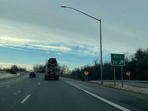
There was a temporary gore sign at the inner loop MD 7 offramp when these photos were taken where the exit number was omitted. Photo taken 01-06-2022.

As the Interstate passes under MD 7, a half-mile advance sign for exit 36, Maryland Route 702 south toward Essex, appears. Photo taken 01-06-2022.

The Beltway reaches exit 36, where the exiting movement onto MD 702 south is straight in orientation; thus, it is in essence I-695 that exits here. MD 702 has a partial interchange with Maryland Route 150 in Essex before downgrading to a controlled-access boulevard toward Back River Neck Road. Photo taken 01-06-2022.

Past the MD 702 split, the inner loop curves wide right and crosses over Amtrak's Northeast Corridor, the first of three times it does so in less than two miles. Sharing this portion of the NEC with Amtrak is MARC's Penn Line, which runs between Washington, DC's Union Station and Perryville in Cecil County, by way of its namesake Penn Station in Baltimore. Photo taken 01-06-2022.

Then, as the inner loop straightens out, it receives incoming traffic from MD 702 north at left. Photo taken 01-06-2022.

There is then a warning to watch for slow moving trucks. Photo taken 01-06-2022.

Another curve to the right nears. Photo taken 01-06-2022.

Within this curve, I-695 goes over the Northeast Corridor a second time. Photo taken 01-06-2022.

The highway straightens out again, but there then comes a sharp curve to the left, where the safe speed is 45 miles per hour. Particular caution is urged to drivers of large trucks, which are prone to tipping along the curve. Photo taken 01-06-2022.

Another pair of warning signs precedes the curve, Meanwhile, according to this variable message sign, the Key Bridge at this time was 9 miles and 10 minutes away. Photo taken 01-06-2022.

Exit 38, intersecting Maryland Route 150 (Eastern Boulevard) running between east Baltimore and Essex, is a mile away. Photo taken 01-06-2022.

Exit 38A can be used to access northbound Maryland Route 151 (North Point Boulevard); southbound MD 151 is accessible two exits later, from exit 40. In the interim at exit 39, meanwhile, is CCBC's Dundalk campus. Photo taken 01-06-2022.

Exit 38 is in ¼ mile, while exit 39 (Maryland Route 157/Merritt Boulevard, to Dundalk) is in half a mile. Photo taken 01-06-2022.

Before exit 38, the Interstate crosses the tidal portion of the Back River, a Chesapeake Bay tributary. Faintly visible mid-ground is the infamous Back River Wastewater Treatment Plant and its distinctive Easter-egg structure. Photo taken 01-06-2022.

Exit 38A to MD 150 west is just past Diamond Point Road's crossing of the Interstate. Westbound, MD 150 goes into east Baltimore where it has an interchange with I-95 near Johns Hopkins Bayview, then passes through Highlandtown and along the south side of Patterson Park. Photo taken 01-06-2022.

The gore sign for exit 38A is well past the beginning of the ramp itself. Photo taken 01-06-2022.

In the midst of the exchange with MD 150, there is a ¾-mile advance sign for exit 40, which leads to MD 151 south and Sparrows Point. Photo taken 01-06-2022.

Traffic from MD 150 east, coming from the direction of Essex and Middle River, enters the inner loop of I-695, and then exit 38B leaves the Interstate for MD 150 west. The sign at the inner loop crossing of MD 150 bills the route of Eastern Avenue, which is the name it bears as opposed to "Boulevard" inside of I-695 as well as east of Carroll Island Road in the Bowleys Quarters area of Middle River. Photo taken 01-06-2022.

Exit 39 is ahead; exit 40 follows in half a mile. Photo taken 01-06-2022.
The exit 39 gore sign, slightly chipped. Photo taken 01-06-2022.

I-695 crosses MD 151 at mile marker 39.5. MD 151 itself runs just shy of 11 miles between the Belair-Edison area of northeast Baltimore and the community of Edgemere near Sparrows Point. Photo taken 01-06-2022.

Exit 41, also billed to Dundalk, intersects Cove Road in half a mile. Photo taken 01-06-2022.

In the meantime, the Interstate passes under a segment of Trappe Road. A disconnected section of it serves as one of Dundalk's local arterials. Photo taken 01-06-2022.

After exit 41, exit 42 is another serving the warehouses and shipping terminals of Sparrows Point. Photo taken 01-06-2022.

Exit 41 sits just ahead. Photo taken 01-06-2022.

Cove Road's bridge over I-695 was being reconstructed at the time of these photos. Photo taken 01-06-2022.

I-695 reassurance follows Cove Road. Photo taken 01-06-2022.

Also off exit 42 is North Point State Park. Photo taken 01-06-2022.