
The epzik8 Webpage
Interstate 95/495 inner loop - Wilson Bridge to Springfield

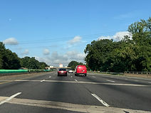
Along the Woodrow Wilson Bridge over the Potomac River, the inner loop of Interstate 95/495 (Capital Beltway) leaves Maryland for Virginia. Beside the state welcome sign, there is signage for the first exit, 177, which intersects U.S. Route 1 (Richmond Highway) with control cities of Alexandria and Fort Belvoir. Photo taken 07-14-2025.

Before either of the offramps to US 1, exit 177C leads toward George Washington's Mount Vernon estate via Church Street, Washington Street and Virginia State Route 400 (G.W. Memorial Parkway). Photo taken 07-14-2025.

The Beltway then passes under Washington Street. Photo taken 07-14-2025.

Exits 177B and C share a few feet of pavement and are marked on one gore sign. Photo taken 07-14-2025.

Approaching exit 177A, there is one-mile advance signage for exit 176 with Virginia State Route 241 (Telegraph Road). Photo taken 07-14-2025.

Meanwhile, the inner loop through carriageway (which bypasses the final three exits in Maryland and all Alexandria exits), has an offramp to south Alexandria's Eisenhower Avenue. Photo taken 07-14-2025.

Exit 177A departs to US 1 south at right. Photo taken 07-14-2025.

Up ahead, one of a parallel trio of onramps leads from US 1 south to the outer loop of the Beltway. Photo taken 07-14-2025.

Then, as the Interstate leaves Alexandria city limits for Fairfax County, a ramp from Eisenhower Avenue via Mill Drive to the outer loop through carriageway passes overhead. Photo taken 07-14-2025.

Exit 176 is preceded by an I-95/495 shield assembly. Photo taken 07-14-2025.

It is then revealed that exit 176 consists of multiple offramps; exit 176B is a local exit to Eisenhower Avenue, while Telegraph Road continues south of the Beltway as state secondary route 611, accessible from exit 176A. Photo taken 07-14-2025.

Exit 176B is a distance ahead of this overhead gantry on the right. Photo taken 07-14-2025.
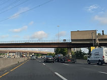
Meanwhile, the Yellow Line of the Washington Metro passes over the Beltway, just feet south of the Eisenhower Avenue station. Photo taken 07-14-2025.

Ahead of exit 176B, a flyover ramp leads from northbound Telegraph to Eisenhower. Photo taken 07-14-2025.

Exit 176A then becomes imminent. Photo taken 07-14-2025.

The exit 176A gore sign sits over an elevated ramp. Photo taken 07-14-2025.

The Beltway goes on to pass over Potomac tributary Cameron Run. Photo taken 07-14-2025.

The inner loop receives two separate lanes of traffic from Telegraph Road. Photo taken 07-14-2025.

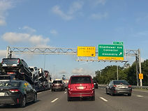
Exit 174 intersects an Eisenhower Avenue Connector in one mile. Photo taken 07-14-2025.

Between exits, there is more I-95/495 reassurance. Photo taken 07-14-2025.
The highway's far-right lane ends immediately after exit 174. Photo taken 07-14-2025.
The exit 174 gore sign. Photo taken 07-14-2025.

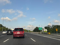
With Alexandria now behind it, the Beltway's surroundings take on an almost rural-looking appearance. Photo taken 07-14-2025.
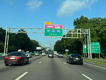
In two miles, at the Springfield Interchange where Interstates 95, 395 and 495 meet, all three highways gain HOV median express toll lanes. An advance sign for exit 173 at Van Dorn Street (SR 613), with control city Franconia, hides behind the right post of this gantry. Photo taken 07-14-2025.

At exit 173, both the Springfield Interchange and the exit just south of it on I-95 (SR 644) are billed as being 1½ miles away. Photo taken 07-14-2025.
The Beltway crosses Van Dorn Street near the same-name Metro station along the parallel Blue Line. Photo taken 07-14-2025.

It then passes under the connector to Van Dorn where the exit is located. Photo taken 07-14-2025.

Toll rates along I-395's HOV lanes up to the Washington, DC border are displayed electronically on this overhead sign. Photo taken 07-14-2025.

Through movements onto I-95 south at the Springfield Interchange are from the left two lanes. This is a convenient arrangement that lets such traffic avoid any lane changing. A sign to the right of that reveals the exit numbers of Springfield Interchange and SR 644 as 170 and 169. Photo taken 07-14-2025.
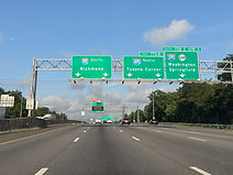
Approaching the interchange, southbound I-95's control city of Virginia state capital Richmond is marked, while the inner loop of I-495 is billed as leading to Tysons Corner (and is also marked as an an exiting movement rather than I-95, despite I-95 and not I-495 leaving the Beltway). Northbound I-395 toward Washington, DC, and SR 644 initialy share an inner loop offramp. Photo taken 07-14-2025.

The Beltway passes over the Metro Blue Line and an Amtrak corridor just before the interchange. Photo taken 07-14-2025.

I-95 and I-495 then have their split at the Springfield Interchange, a notorious junction with many ramps locally nicknamed the Mixing Bowl. I-495 will continue north and west of here through Fairfax County's dense suburbia before crossing the Potomac back into Maryland. Photo taken 07-14-2025.